Check out our Holiday Auction - Sign Up for the Utah Snow and Avalanche Workshop (USAW)

Forecast for the Logan Area Mountains

Trent Meisenheimer
Issued by Trent Meisenheimer on
Saturday morning, January 27, 2024
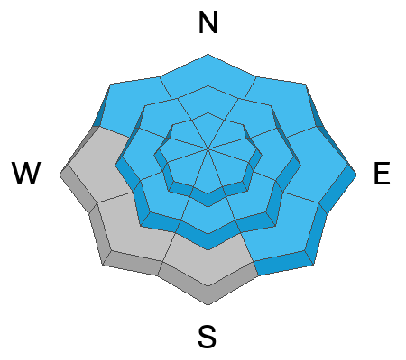
Elevated avalanche conditions exist at all elevations; the danger is MODERATE, and human-triggered avalanches are possible. People could trigger dangerous slab avalanches up to three feet deep and a couple hundred feet wide, failing on a buried persistent weak layer, especially where the snow is relatively shallow and in steep, previously drifted rocky terrain.
With unseasonably warm temperatures and rain, the low-elevation snowpack is soft and saturated. Triggering a wet avalanche in terrain with poor snow structure, like the steep banks next to the Logan River, is also possible.
Low
Moderate
Considerable
High
Extreme
Learn how to read the forecast here
Special Announcements
Sign up for forecast region-specific text message alerts. You will receive messages about changing avalanche conditions, watches, and warnings...HERE.
Weather and Snow
Under partly cloudy skies, mountain temperatures range from 16-23 °F. The wind picked up in the past few hours and now blows 15-25 mph from the west, with gusts reaching close to 30 mph across the upper elevations.
As high pressure takes hold of northern Utah, we will see plenty of sunshine today with clouds at times. Temperatures will warm into the mid-30s °F at about 8,000'. Westerly winds will continue to blow at speeds in the 15-25 mph range at ridgetop.
The riding and turning conditions are fantastic as we have soft-settled powder on a supportable base. Yesterday's sun poking through the clouds was enough to kiss the snow surface on the southerly aspects, and this morning you will find a zipper crust. Otherwise, it's powder snow on all other aspects and elevations.
Recent Avalanches
Yesterday, there was one report of an avalanche from the Wellsville Mountains under Mendon Peak, where a rock slab heated up enough to shed some snow, creating an avalanche. Otherwise, it's been pretty quiet. Check out local observations and avalanches HERE.
Ad
Avalanche Problem #1
Persistent Weak Layer
Type
Location
Likelihood
Size
Description
Today, human-triggered slab avalanches failing on a buried persistent weak layer could be large and life-threatening. During the last big storm, heavy snowfall and drifting by winds from the west overloaded slopes plagued by widespread buried layers of weak, sugary snow or facets and feathery surface hoar that developed during the prolonged December dry spell.
Paige and I were in Tony Grove yesterday, and even though it's becoming less likely to trigger an avalanche, we still felt uncomfortable riding bigger, more consequential lines. We rode a few slopes near or approaching 30 degrees in steepness and still had a blast. We also avoided being under avalanche terrain as we do not trust our snowpack just yet.
If you do choose to ride steep avalanche terrain stack the odds in your favor by doing the following:
  • Ride one at a time in avalanche terrain and keep an eye on the person the entire time from a safe spot.
  • Choose a slope where the runout is free of trees, rocks, or cliffs. Smooth slope.
  • Do not stand or park underneath steep slopes, as avalanches can run long distances into the flats.
  • Be prepared for a rescue, as it remains possible to trigger a slab avalanche.
My advice: is leave the steep terrain alone for the weekend. Why ruin your day with an avalanche? Remember, sometimes even when you do everything right, the outcome can still be catastrophic. Let's give the snowpack a little more time to adjust and gain more strength. It won't be long before we can get into bigger terrain without the risk of triggering an avalanche that can kill you.
Additional Information
Suspect terrain includes areas with shallower snow and a thinner slab layer. On Wednesday, we had mixed stability test results in the Northern Bear River Range and found areas with shallow snow and more unstable conditions on a mid-elevation northwest-facing slope near Midnight Mountain.
General Announcements
-Come practice companion rescue with your backcountry partners at the Franklin Basin TH beacon training park. video HERE.
-For all questions on forecasts, education, Know Before You Go, events, online purchases, or fundraising: call 801-365-5522.
-To report an avalanche or submit an observation from the backcountry: go HERE.
-We will update this forecast by 7:30 AM tomorrow.
This forecast is from the U.S.D.A. Forest Service, which is solely responsible for its content. This forecast describes general avalanche conditions, and local variations always occur.