Join us at our 2nd Annual Blizzard Ball

Forecast for the Skyline Area Mountains

Brett Kobernik
Issued by Brett Kobernik on
Friday morning, January 5, 2024
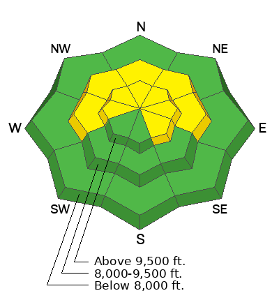
The avalanche danger is starting to increase and will continue to do so through the weekend. There is a MODERATE avalanche danger today. Small human triggered avalanches are possible. The most likely places to find trouble are on north through east facing slopes just below ridgelines where the wind has been depositing snow.
Low
Moderate
Considerable
High
Extreme
Learn how to read the forecast here
Weather and Snow
Current Conditions: I'm pleased to say that these recent periods of snow have exceded my expectations. We've picked up 3 to 6 inches of new snow. The central Skyline (Horseshoe Mtn-Ephraim Canyon) has done the best which is not uncommon with a northwest flow. Temperatures have been in the teens. The wind has been moderate to strong from the northwest.
Mountain Weather: We should see snowfall today with a few more inches trickling in by Saturday morning. Temperatures will be in the teens and wind will be from the northwest with moderate to strong speeds along the exposed ridges. Another system will move through Sunday bringing a decent shot of snow. Models indicate a string of storms over the next couple of weeks with VERY impressive water amounts. Let's hope this solution holds true.
Ad
Avalanche Problem #1
Wind Drifted Snow
Type
Location
Likelihood
Size
Description
Your biggest threat today is triggering a fresh wind slab. Moderate to strong speed wind from the northwest will have drifted the new snow into slabs that will most likely be sensitive today. The most likely places to trigger an avalanche are just below ridges in the mid and upper elevations on north through southeast facing slopes. I'm not anticipating very large avalanches but large enough to cause concern.
Avalanche Problem #2
Persistent Weak Layer
Type
Location
Likelihood
Size
Description
A secondary concern is all the weak faceted snow that our base is comprised of. This "Persistent Weak Layer" is going to cause problems soon and will become our primary concern. I don't think there is enough new snow nor does the slab have the right structure yet for widespread avalanche danger. However, be aware that the avalanche danger is increasing. Shooting cracks and "whoomping" (collapsing of the snowpack) are sure signs of unstable snow. Hang on, things are probably going to get ugly.
General Announcements
This forecast is from the U.S.D.A. Forest Service, which is solely responsible for its content. This forecast describes general avalanche conditions and local variations always occur.