UDOT PLANNED AVALANCHE CLOSURES!!

Forecast for the Skyline Area Mountains

Brett Kobernik
Issued by Brett Kobernik on
Wednesday morning, December 6, 2023
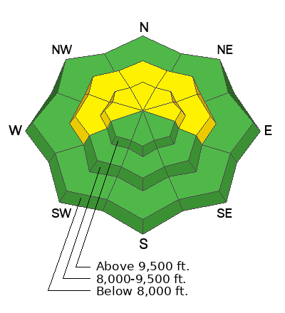
The overall avalanche danger is MODERATE today. Human triggered slab avalanches are possible today especially in the higher elevation more northerly facing steep terrain. You will simply want to avoid that terrain to stay out of trouble.
Low
Moderate
Considerable
High
Extreme
Learn how to read the forecast here
Special Announcements
The 5th Annual Avalanche Awareness Week is December 3-10. The week's goal is to save lives through activities that promote avalanche awareness, education, and safety. We have a variety of events around the state. Find an event near you.
Weather and Snow
Current Conditions: Temperatures were quite warm on Tuesday pushing into the low to mid 40s and dropping back into the mid 20s overnight. Wind from the southwest is slowly starting to increase this morning but still remains fairly light. Average snow depths in the higher terrain average 20 inches with the more favored locations over two feet.
Mountain Weather: We'll have mostly sunny skies with temperatures again pushing up to around 40 in the high country. Wind from the southwest will be light to moderate in speed, gradually increasing as the day goes on. The storm for Thursday into Friday still does not look very promising to me this morning and I'm only expecting a few inches total by Saturday. There are more chances for snow starting Sunday and into mid week.
Recent Avalanches
My partner and I remotely triggered (triggered from a distance) a medium sized avalanche on Tuesday. It released in a small northwest facing bowl at about 10,500 feet in elevation. We did not realize it had released until we were backtracking back down the mountain and stumbled onto it. It was 24 to 30 inches deep and approximately 150' wide. It produced a pile of debris about 5 or 6 feet deep.
Ad
Avalanche Problem #1
Persistent Weak Layer
Type
Location
Likelihood
Size
Description
Unfortunately, I've had to start using the Persistent Weak Layer avalanche problem in light of what we found during fieldwork on Tuesday. Remotely triggered avalanches, poor snow pit stability tests, and facets identified near the base of the snowpack all point to unstable conditions. Because I haven't traveled around extensively yet, I'm not really sure how widespread this problem is. There is no question that it is present in the upper elevation northwest through northeast facing slopes. I would use caution on east and west facing slopes as well as those same aspects in the mid elevations. The pattern will become clear after some more fieldwork.
General Announcements
This forecast is from the U.S.D.A. Forest Service, which is solely responsible for its content. This forecast describes general avalanche conditions and local variations always occur.