Check out our Holiday Auction - Sign Up for the Utah Snow and Avalanche Workshop (USAW)

Forecast for the Ogden Area Mountains

Trent Meisenheimer
Issued by Trent Meisenheimer on
Tuesday morning, December 5, 2023
The avalanche danger is CONSIDERABLE on slopes that face west, northwest, north, northeast, and east. Here, it is likely to trigger an avalanche that fails on a Persistent Weak Layer of faceted snow. Dangerous avalanche conditions exist. Natural avalanches are possible, and human-triggered avalanches are likely.
On many mid and upper-elevation slopes, you will find a MODERATE avalanche danger, where it's possible to trigger a Wind-Drifted snow avalanche. Below 7,000', the snow will be crusted and frozen and, therefore, has a LOW avalanche danger.
Low
Moderate
Considerable
High
Extreme
Learn how to read the forecast here
Special Announcements
The 5th Annual Avalanche Awareness Week is December 3-10. The week's goal is to save lives through activities that promote avalanche awareness, education, and safety. We have a variety of events around the state.

Announcement: Join us for a FREE Know Before You Go Avalanche Awareness Presentation in Pleasant View at Young Powersports on Tuesday, December 5 at 6 PM or in Centerville on Thursday, December 7 at Young Powersports.
Weather and Snow
Under clear skies, the mountain sunrise should be spectacular, as the peaks are pasted white from four days of heavy snowfall. Mountain temperatures range from 25-34°F. Winds from the northwest blow 10-20 mph across the upper elevations.
We will see plenty of sunshine today as high pressure sets in. Temperatures will climb into the mid-30s °F at 8,500'. Winds will be from the west at speeds of 10-20 mph. Later in the day, southerly winds might pick up and blow 10-20 mph as a small storm approaches for Wednesday. Storm totals for the past four days are as follows:
  • Upper Cottonwoods: 40-50" snow (3.52-5.03" water)
  • Park City Ridgeline: 20-30" snow (1.80-2.58" water)
  • Ogden Mountains: 30-50" snow (2.85-5.68" water)
  • Provo Mountains: 20-30" snow (1.58-2.25" water)
Recent Avalanches
Over the past few days, we've gone through a large natural avalanche cycle throughout the mountains of northern Utah. Control work continues to produce many large and destructive avalanches breaking 2-5 feet deep and hundreds of feet wide. In the Cottonwoods Canyons, reports of large remotely triggered slides, as well as all the natural avalanche activity, keeps pouring into our observation cue. Be sure to check it out.
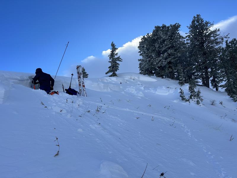
Yesterday, Drew Hardesty and Zack Little were on Cutler Ridge and found a natural avalanche that failed into weak faceted snow on a steep rollover. The avalanche was 2.5 feet deep, 150 feet wide, and traveled about 90 vertical to the flats (picture below).
Photo: Investigating an avalanche on Cutler Ridge.
Ad
Avalanche Problem #1
Persistent Weak Layer
Type
Location
Likelihood
Size
Description
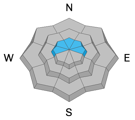
On northerly facing terrain at the upper elevations (see locator rose), you will find weak faceted snow at the base of our snowpack from early season October / November storms that became weak and faceted. Over the past four days, we've seen strong winds and heavy snowfall that has overloaded this weak foundation. Deep and dangerous slab avalanches 2-5 feet deep and hundreds of feet wide are likely today.
Avalanche Problem #2
Wind Drifted Snow
Type
Location
Likelihood
Size
Description
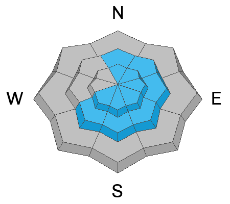
Northwest winds have blown relentlessly at 15-30 mph, gusting into the 30s and 40s across the upper-elevation terrain over the past four days. These winds and heavy snowfall are the perfect recipe for Wind-Drifted Snow avalanches. These avalanches could be 2-5 feet deep and hundreds of feet wide. Watch for and avoid any steep slopes that are heavily drifted.
On the shady aspects, any wind slab you trigger has the potential to step down deeper into weak faceted snow, making it a deeper, wider, and, therefore, a much more dangerous avalanche.
General Announcements
This information does not apply to developed ski areas or highways where avalanche control is normally done. This forecast is from the U.S.D.A. Forest Service, which is solely responsible for its content. This forecast describes general avalanche conditions and local variations always occur.