Check out our Holiday Auction - Sign Up for the Utah Snow and Avalanche Workshop (USAW)

Observation: USA Bowl

Observation Date
3/30/2023
Observer Name
Gagne
Region
Salt Lake » Big Cottonwood Canyon » USA Bowl
Location Name or Route
USA Bowl - Monitors
Weather
Sky
Obscured
Precipitation
Light Snowfall
Wind Direction
West
Wind Speed
Moderate
Weather Comments
Periods of light to moderate snowfall with occasional glimpses of sun. Winds picked up and were drifting snow by around 1200.
Snow Characteristics
New Snow Depth
14"
New Snow Density
Medium
Snow Surface Conditions
Powder
Snow Characteristics Comments
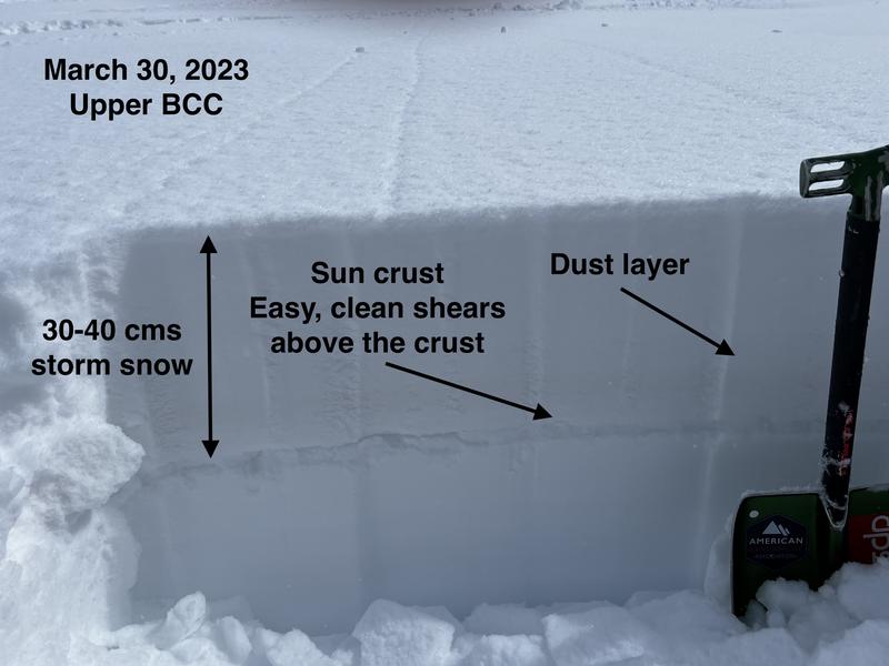
30-40 cms settled storm snow. There was a brief period of greenhousing, but I suspect this was *very* location-specific.
Red Flags
Red Flags
Recent Avalanches
Heavy Snowfall
Wind Loading
Red Flags Comments
Continued heavy snowfall and winds plus lots of recent avalanches are enough red flags to warrant backing off of any avalanche terrain.
Avalanche Problem #1
Problem
New Snow
Trend
Increasing Danger
Problem #1 Comments
Lots of new snow with wind drifting. Plenty of storm snow interfaces that remain reactive, some that are buried 2-4' deep.
Avalanche Problem #2
Problem
Wind Drifted Snow
Trend
Increasing Danger
Problem #2 Comments
Although we couldn't get onto any wind-loaded slopes today, the winds have been strong enough to create plenty of new wind drifts. The increase in winds in the early afternoon likely created additional drifts.
Comments
With such heavy snowfall over the past week and lots of large avalanches, the only recipe right now is to simply avoid avalanche terrain. On my field work today, I thought I'd focus on the sun crust that formed Tuesday and yesterday, and see how the storm snow bonded to it. Strong sunshine the past two days created a crust on the southern half of the compass which was buried by snowfall overnight. In several pits today, I was getting clean shears at this interface, shearing on low-density stellars just above the crust (a poor bond). The storm snow wasn't a cohesive slab and I could only get ECTN in extended column tests.
For me, this indicates that any new storm snow and/or wind-blown snow may fail at this interface just above the crust where the crust provides a bed surface.
Today's Observed Danger Rating
Considerable
Tomorrows Estimated Danger Rating
High
Coordinates