Sign Up for the Utah Snow and Avalanche Workshop (USAW) on December 7th!

Observation: Monitors

Observation Date
3/16/2023
Observer Name
Gagne/Frey
Region
Salt Lake » Park City Ridgeline » Monitors
Location Name or Route
USA Bowl - Monitors
Weather
Sky
Clear
Wind Direction
Northeast
Wind Speed
Light
Weather Comments
E/NE winds, although no wind-drifting occurring.
Snow Characteristics
New Snow Depth
12"
New Snow Density
Medium
Snow Surface Conditions
Powder
Wind Crust
Damp
Snow Characteristics Comments
~30 cms of settled storm snow outside of wind-affected terrain. Plenty of wind-affected snow on all aspects above 9,000'. Some solar aspects were damp when we were exiting at 2 pm and will be crusted on Friday morning.
Red Flags
Red Flags
Recent Avalanches
Red Flags Comments
Numerous avalanches were reported Wednesday, overnight into Thursday, and during the day today. Recent avalanches are the reddest of the red flags!
Avalanche Problem #1
Problem
Wind Drifted Snow
Trend
Decreasing Danger
Problem #1 Comments
Over the past 36 hours, winds on Hidden Peak at 11,000'
3/15 0600 (6 am) S (gusting to 60 mph)
3/15 1200 (noon) W/NW (gusting upper 30's mph)
3/16 0200 (2 am) N (gusting to upper 20's mph)
3/16 1300 (1 pm) NE (gusting to 30 mph)
This period of sustained moderate to strong winds from every cardinal direction has left widespread wind-drifted snow at the mid and upper elevations.
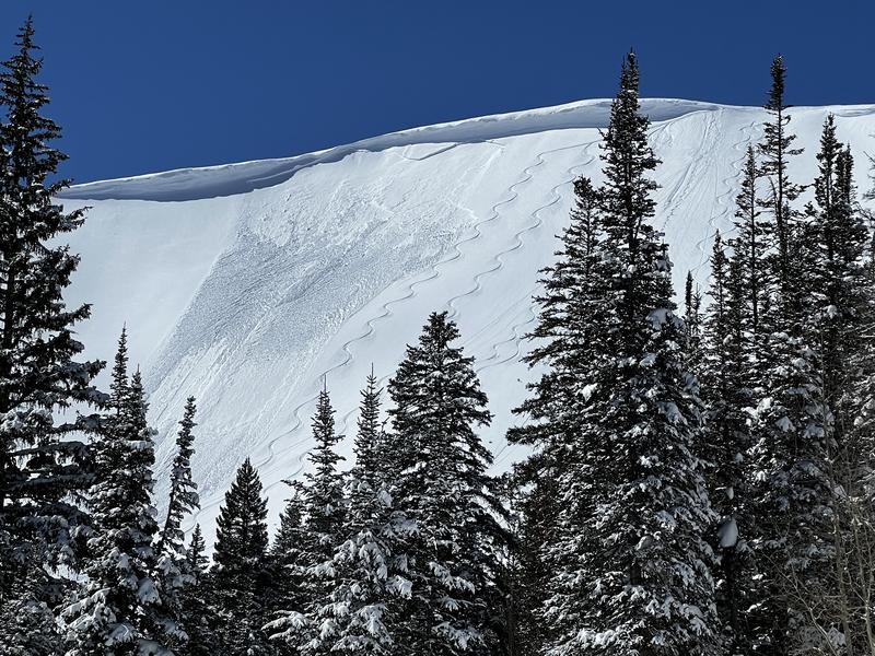
One pit today on a West aspect at 9,600' had a 15 cm 1F-hard wind slab where the extended column failed upon isolation (ECTPV), failing on softer snow underneath the wind drift. We also saw evidence of what appears to be a natural avalanche from a cornice fall in South Monitor (photo below). Given the widespread natural avalanche cycle on Wednesday and overnight into Thursday morning as well as skier-triggered avalanches on Thursday are plenty of evidence these recent wind drifts are still sensitive and will need more time to stabilize.
Comments
Travel today was USA Bowl along the PC ridgeline and down the lower-angled "West Monitor Sneak". Cold temperatures have locked up low-elevation snow which was saturated from Wednesday's rain. Outside of wind-afffected terrain, the danger is moving to Moderate, but there has been enough avalanche activity in wind-drifted terrain to keep that at Considerable.
Photo of likely natural avalanche in South Monitor.
Today's Observed Danger Rating
Considerable
Tomorrows Estimated Danger Rating
Considerable
Coordinates