Observation Date
3/9/2023
Observer Name
Kelly, Grainger
Region
Ogden » Snowbasin Backcountry
Location Name or Route
Sloth Ridge
Comments
Failure with propagation at 165cm from the ground on a layer of broken stellars above the crust. This failed at 31 and 21 with an extended column test. There were 2 layers of percolated water columns 142cm from the ground and 110 from the ground. Both of these layers of columns were surrounded by rounds and frozen solid. The layer at 142cm had a thin melt freeze water layer in some locations. It will be interesting to see how any rain effects the top layer of the snow at this elevation.

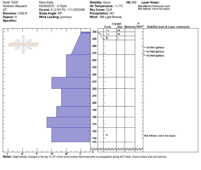
Second snow pit was on a north facing slope at 7250'. This slope was 40 degrees in steepness and had previous wind loading. Primary concern were very slight density changes in the top 12-16" of new snow that will most likely settle out over time. Snow surface was dry.

We went out with the intention of looking at snow in lower elevation zones that has the a good chance of being impacted by rain during tomorrow's storm. We wondered how things might react to direct rain on snow. There are many factors at play when it rains on snow for the first time. Areas of concern are lower elevation slopes where one can still find a weak layer on the southeasterly aspects above a crust. The riding on the north facing slopes was still soft and dry while the southerly aspects had taken a bit of sun and were a melt-freeze crust by our exit at 400pm.
Today's Observed Danger Rating
Moderate
Tomorrows Estimated Danger Rating
Moderate
Coordinates


