Observation Date
1/13/2023
Observer Name
Staples et al
Region
Uintas » Murdock Basin
Location Name or Route
Murdock Basin and Iron Mine Mtn
Comments
Dug in three places.
- 9270 ft, West facing, 165 cm of snow (5' 5"), several ECTN's in the new snow but they weren't as clean as last time I was here 3 days ago. The ECT did not break on the November facets.
- 9500 ft, N facing, 180 cm of snow (5' 11"), November facets 4F hardness and 30 cm (1 ft) above the ground
- 10,310 ft, NW facing, 190 of snow (6' 3"), November facets 4F- hardness and 45 cm above the ground. (photo and profile below)
It's becoming a lot of work to dig to the ground which says something. Stability in the new snow has really improved and it's not breaking as much in tests. The only issue I would worry about with the new snow is fresh slabs of wind drifted snow.
As for triggering a slide on the PWL of November facets - it's unlikely near and below treeline. The only place I could see triggering a slide on this layer is above treeline in the alpine zone on a slope loaded heavily by winds with a thin area near some rocks. The likelihood of that happening is going down quickly too.


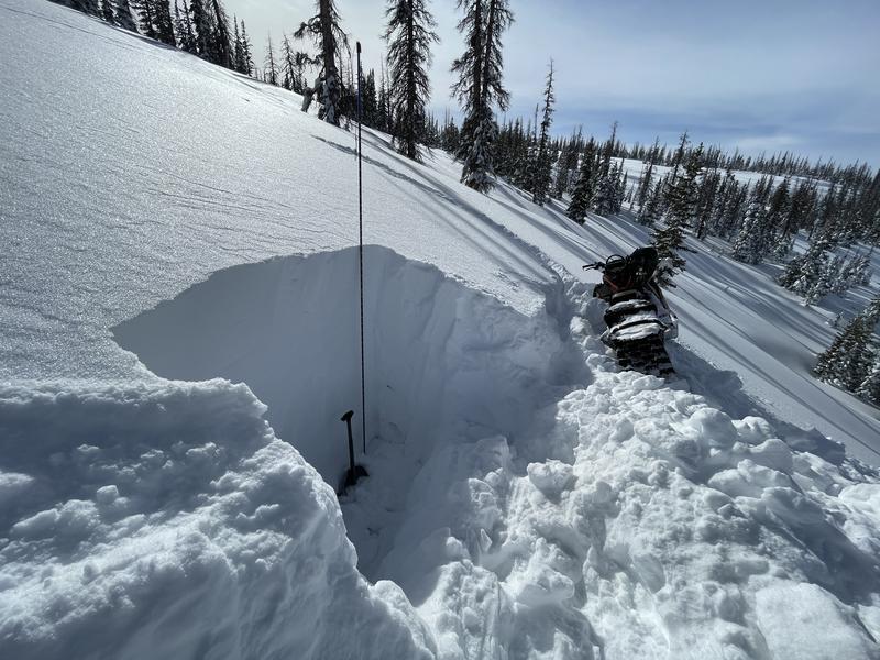
Photo below shows some of the low elevation drifting. I didn't find the same drifting higher at 10,000 ft.

Video
Below treeline on slopes with no wind loading, the danger is LOW
Today's Observed Danger Rating
Low
Tomorrows Estimated Danger Rating
Low
Coordinates


