Observation Date
1/10/2023
Observer Name
Gagne/Heilweil
Region
Salt Lake » Big Cottonwood Canyon » 10420
Location Name or Route
10,420'
Weather
Sky
Overcast
Precipitation
Light Snowfall
Wind Direction
Southwest
Wind Speed
Moderate
Weather Comments
Winds diminished during the morning with light winds and moderate gusts.
Snow Characteristics
New Snow Depth
16"
New Snow Density
High
Snow Surface Conditions
Powder
Snow Characteristics Comments
Heavy, dense new snow that was inverted.
Red Flags
Red Flags
Heavy Snowfall
Wind Loading
Cracking
Red Flags Comments
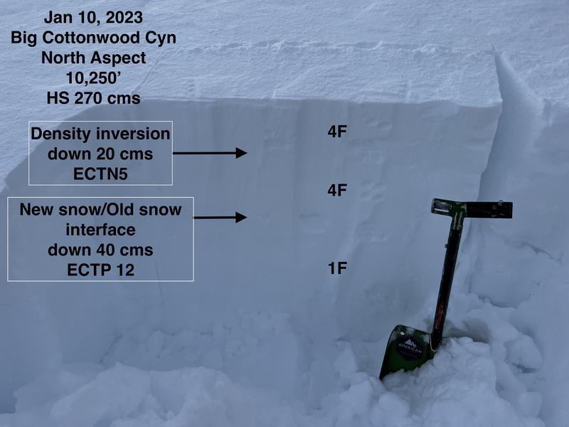
Lots of cracking within storm snow - the weak layer was a density inversion with lower-density snow down 20 cms (8") capped with much-higher density snow (containing some graupel) above.
Avalanche Problem #1
Problem
New Snow
Trend
Increasing Danger
Problem #1 Comments
Density inversions within the storm snow as well as clean shears and ECT full propagation at the new snow/old snow interface down 40 cms. Ordinarily, storm snow weaknesses settle out fairly quickly (sometimes a matter of hours) but with more snow forecast for overnight, the trend for this problem will increase.
Avalanche Problem #2
Problem
Wind Drifted Snow
Trend
Increasing Danger
Problem #2 Comments
We were also able to get cracking in areas with wind-drifted snow up to 30-40 cms thick. With more wind out of the SW and switching to the NW, the trend for this problem will increase.
Comments
Lots of localized cracking and a density inversion indicating a sensitive dense storm slab on top of weaker snow kept us to lower-angled terrain. Pits were getting ECTN at the density inversion down 15-20 cms (6-8") but we also got full propagation ECT scores (ECTP12 - ECTP21) down 40 cms. Photo below.
Today's Observed Danger Rating
Considerable
Tomorrows Estimated Danger Rating
High
Coordinates