AVALANCHE WARNING!! Tap for info

Forecast for the Uintas Area Mountains

Craig Gordon
Issued by Craig Gordon on
Wednesday morning, January 4, 2023
We are so close to turning the corner, but we're not there just yet. Let's continue pumping the brakes and not stomping on the gas pedal because any avalanche that fails on weak, sugary, midpack snow is gonna be deep, dangerous, and unsurvivable.
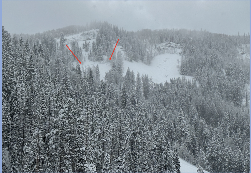
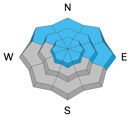
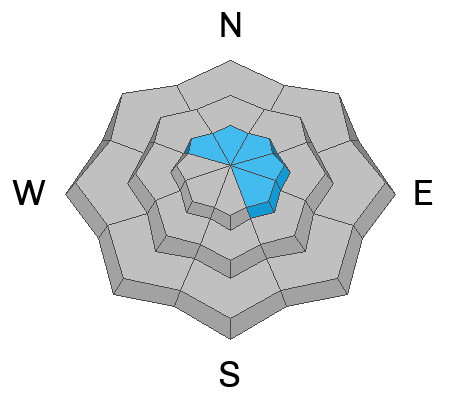
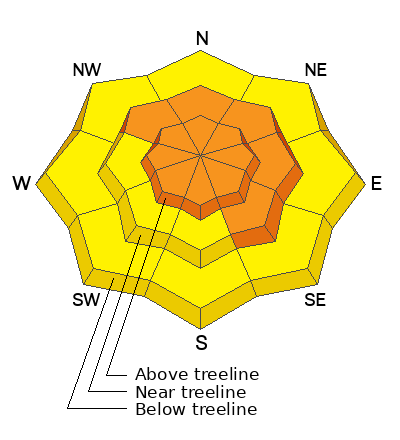
CONSIDERABLE avalanche danger is found on steep, mid and upper elevation slopes in the wind zone at and above treeline. The danger is most pronounced in terrain facing the north half of the compass, particularly on slopes with an easterly component to their aspect. Human triggered avalanches are PROBABLE. Pockety and a little more predictable, don't get surprised... steep, lower elevation terrain near and below treeline is a player as well. You'll find MODERATE avalanche danger with human triggered avalanches involving the New Years storm snow POSSIBLE on steep, shady slopes.
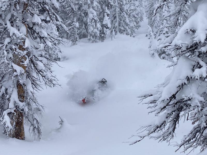
My exit strategy and plan for mountain longevity-
I'm having a blast on low angle slopes with no overhead hazard, simply meaning... no steep slopes above or adjacent to where I'm riding.

Low
Moderate
Considerable
High
Extreme
Learn how to read the forecast here
Special Announcements
My State of the Snowpack prezo scheduled for tonight Wednesday Jan. 4th at PC Library is being rescheduled for a later date. I will loop you in once we establish new time and date.
Weather and Snow
Nowcast- As our big storm slides east, we get a slight break in the action and partly cloudy skies. Temperatures have been falling since about suppertime Tuesday and currently register in the teens at the trailheads and single digits along the ridges. West and southwest bumped into the mid 20's overnight, delivering windchill registering to -15 degrees near the high peaks. On a go-anywhere base, riding and turning conditions are as good as they get!
Forecast- Look for partly cloudy skies with a few scattered snow showers lingering over the Uinta's. Temperatures slowly warm into the mid 20's, while westerly winds bump into the 30's as the day wares on. Clouds increase late in the day and overnight lows dip into the teens.
Futurecast- Light snow develops early Thursday, but then increases in intensity late in the day and overnight. 5"-10" looks like a solid bet by midday Friday. Nothing like the last colossal event, but a nice refresh with warm, dry weather settling in for Sunday and Monday.
Trenchtown Rocks and an ambidextrous Dan Gardiner proves he can get the snorkel in his mouth whilst grabbing a fist fulla' throttle. Yup... it's that deep!
Mark was in the Mirror Lake zone Monday and has an excellent trip report, suggesting... the Uinta's are fat, white, and pasted. Seek out wind sheltered terrain and you'll be greeted with ridiculously deep snow.
Ted's been in the Gold Hill zone and reports a phat, white, North Slope. His most excellent writeup and insight are found HERE.
Meanwhile, Micheal J visited lower Weber Canyon and has a great report HERE.

Lots of excellent trip reports and recent obs are found HERE.
Recent Avalanches
Inspired Summit Adventures founder and owner Shaun Raskin is not only an amazing human and guide extraordinaire, she's also got a keen mountain sense and a sharp eye for avalanches. Yesterday Shaun spotted this slide with an unknown trigger, low in Mill Hollow, just south of Highway 35.
Additional avy activity and a slew of Uinta obs are HERE.
Ad
Avalanche Problem #1
Persistent Weak Layer
Type
Location
Likelihood
Size
Description
The good news-
The big New Years storm delivered colossal water numbers and huge snow amounts which adds thick, warm layers of insulation to our snowpack.
The flake news-
Weak, sugary, surface layers can develop very quickly... in fact, sometimes in just a matter of a few hours. However, deeper persistent weak layers (PWL) just like we're dealing with in the mid portion of our snowpack, need some time to change and become comfortable in their own skin. The good news is... stability tests along with the shear amount of new snow and water weight suggest we are headed in the right direction and in just a short time I think we'll be good to go. However, we're not there just yet and now is the time to pump the brakes and exercise a bit of patience. The short term pain is gonna lead to long term gain. With all the great low angle riding available, there's no reason to pull on the avalanche dragons tail.

Avalanche Problem #2
Wind Drifted Snow
Type
Location
Likelihood
Size
Description
Found on the leeward side of upper elevation ridges, a few fresh wind drifts formed overnight and they'll be sensitive to our additional weight today. While it's becoming more the exception than the rule, once triggered, a seemingly manageable wind drift may break to weaker layers of snow buried deeper in the snowpack as it crashes down onto the slope below, producing an avalanche that quickly gets out of hand. Lose the wind and you lose the problem. The key to riding safely is simply avoiding fat rounded pillows of snow, especially if they're sounding hollow like a drum.
Additional Information
Weather stations-
And... we were super busy this summer upgrading the western Uinta weather station network and this real-time winter info is found HERE (click weather stations, and then on the Western Uinta tab)
Observations-
Your observations are important, so please let me know what you're seeing... click HERE and contribute to this amazing community-based program
General Announcements
Issued at 03:41 on Wednesday January 4th, this forecast expires 24 hours after the date and time posted, but will be updated by 07:00 Thursday January 5th, 2023.
Before it gets too crazy, now is the time to book an avalanche awareness presentation for your group, club, or posse. You can reach Craig directly at 801-231-2170 or [email protected].

This forecast is from the U.S.D.A. Forest Service, which is solely responsible for its content. This forecast describes general avalanche conditions and local variations always occur.