Observation Date
12/29/2022
Observer Name
Davis/Slack
Region
Logan » Franklin Basin
Location Name or Route
Franklin Basin TH-Steep Hollow-Boss Canyon
Weather
Sky
Overcast
Precipitation
Light Snowfall
Wind Direction
South
Wind Speed
Light
Weather Comments
The weather was overcast with on and off lgt flurries. Winds were from the south gusting to 20mph in the exposed high terrain. We observed about 8-12" of new snow.
Snow Characteristics
New Snow Depth
10"
New Snow Density
Low
Snow Surface Conditions
Powder
Snow Characteristics Comments
Snow surface was anywhere from 8-12" of loose pow on top of a firm base which provided great traction on a snowmobile. Total snow depth was close to 60".
Red Flags
Red Flags
Wind Loading
Poor Snowpack Structure
Red Flags Comments
We came across a lot of downed tress, drifts and scoured snow from last weeks storm. Wind loading had occurred on the northerly and easterly slopes which is resting on the November PWL at about 35" below the surface.
Avalanche Problem #1
Problem
Wind Drifted Snow
Trend
Same
Problem #1 Comments
Avalanche Problem #2
Problem
Persistent Weak Layer
Trend
Same
Problem #2 Comments
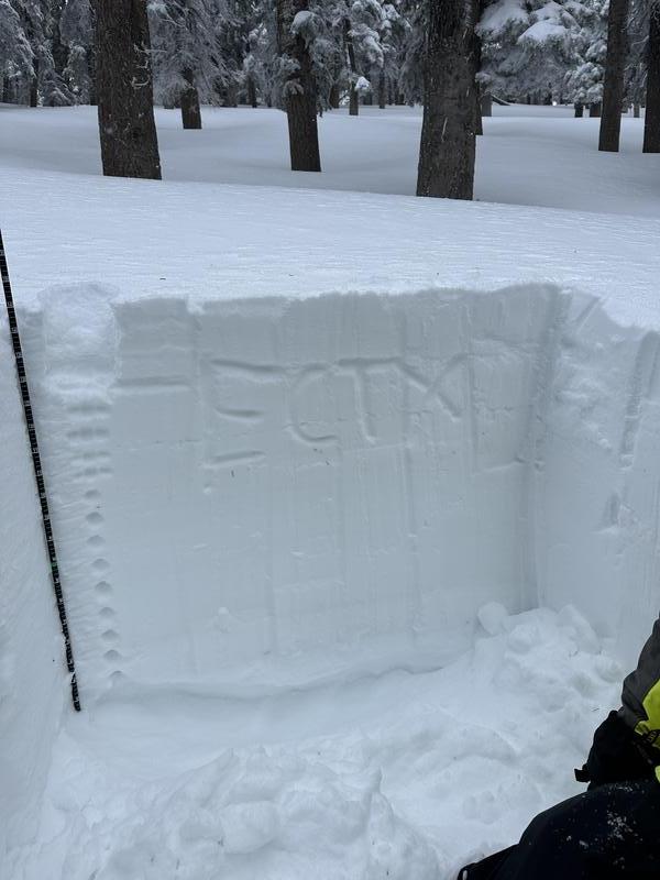
November PWL is still present, but seems to be gaining strength. We ran a Extended Column test with no results. I.e no collapse.
Snow Profile
Aspect
North
Elevation
8,900'
Slope Angle
23°
Comments
We dug down to the November PWL to run a ECT with no results. The pack appears to be gaining strength. However, we are due for another heavy storm over the weekend and that layer of November facets could still prove problematic.
As seen in the photo above, we dug down (bottom) to the November facet (PWL) to conduct a ECT. No results, however, the facets are still there and could re-awaken with a new load of snow.
Today's Observed Danger Rating
Considerable
Tomorrows Estimated Danger Rating
Moderate