Join us at our 2nd Annual Blizzard Ball

Forecast for the Moab Area Mountains

Eric Trenbeath
Issued by Eric Trenbeath on
Saturday morning, December 10, 2022
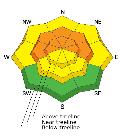
The avalanche danger is CONSIDERABLE near treeline and above on slopes that face W through N through E. Dangerous, human triggered avalanches, failing 2'-4' deep on a buried persistent weak layer are likely. On southerly aspects, and at lower elevations, the avalanche danger is MODERATE and human triggered avalanches are possible. Stick to low angle slopes less steep than 30 degrees, and continue to be mindful of the low snow conditions.
Low
Moderate
Considerable
High
Extreme
Learn how to read the forecast here
Special Announcements
Road Conditions: Grand County has plowed the road to Geyser Pass Trailhead. The road surface is snow packed over dirt. AWD and good tires are recommended.
Grooming: The Geyser Pass Road above the winter trailhead closes on Dec 15. Grooming will commence after that.
Join us for the 1st Annual UAC Moab/LUNA Winter Kickoff Party on Saturday, Dec 10 at the MARC. The event will be from 7-9 PM. Get your tickets here.
The Utah Avalanche Center wants to give you free batteries for your beacons. Head on over to Moab Gear Trader to pick up your free batteries. While you are there, scan a QR code to fill out a quick survey and be entered to win some avalanche rescue gear.
Join the Utah Avalanche Center and the Division of Outdoor Recreation to celebrate the Fourth Annual Avalanche Awareness Week, from December 4 - December 11. Click HERE to view a full list of events throughout the state.
Weather and Snow
24 Hour Snow 0" 72 Hour Snow 14" Season Total Snow 55" Base Depth at Gold Basin 32"
Winds on Pre Laurel Peak S 10-15 G20 Temp 15F
Weather
Skies are clear, and overnight southerly winds have been light to moderate. Look for increasing clouds this afternoon as the next storm system develops off the Pacific Northwest coast. Southerly winds will be on the increase tonight and tomorrow. The storm moves inland on Sunday with the front reaching our area by Sunday night. Monday looks to be the main event, but this system is now showing a lack of deep, sustained moisture. Snow totals are looking like about 6" but we'll gladly take it.
General Conditions
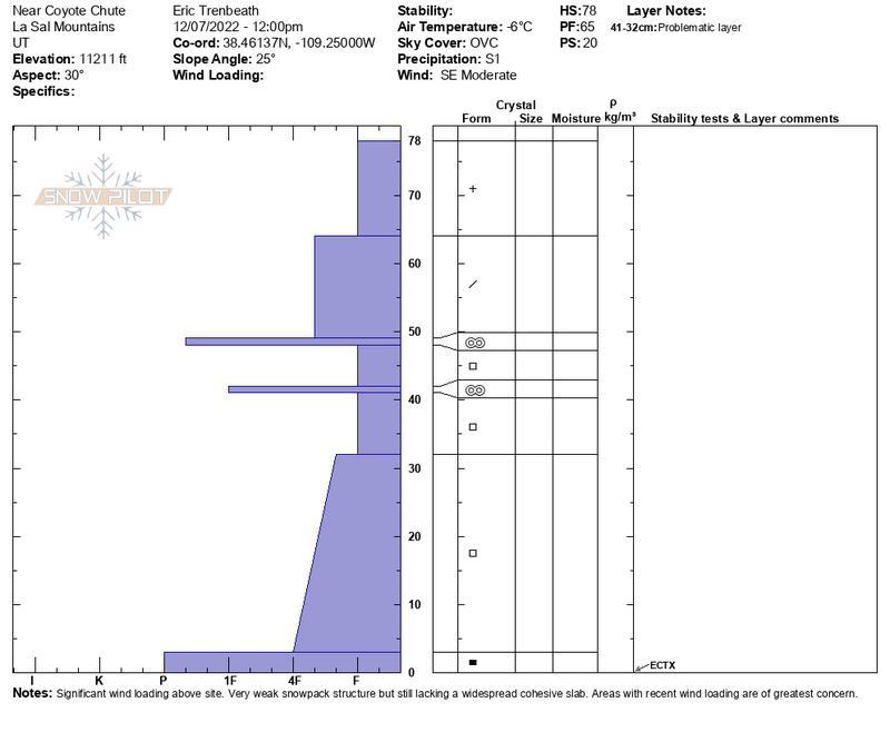
The mid week storm gave the snowpack a much needed boost and there is now enough coverage for cautious backcountry skiing and riding. The recent snow load also pushed the fragile snowpack to its breaking point. Observers in the backcountry continue to report collapsing and whumphing though not as widespread as the day before. See this observation from Tim Mathews. The entire snowpack beneath the November 28 storm is loose, weak, and faceted and we now have 18" - 20" of snow sitting on top of that with considerably more in wind drifted areas. This translates to a poor snowpack structure and unstable avalanche conditions.
This video was taken on Wednesday during the storm. It illustrates the current snowpack structure and weather leading up to the current conditions.

Snowpack and Weather Data
Gold Basin Storm Stake (10,000')
Gold Basin SNOTEL site (10,000')
SNOTEL site near Geyser Pass Winter Trailhead (9600')
Wind Station on Pre-Laurel Peak (11,400')
NWS forecast for the La Sal Mountains.
Recent Avalanches
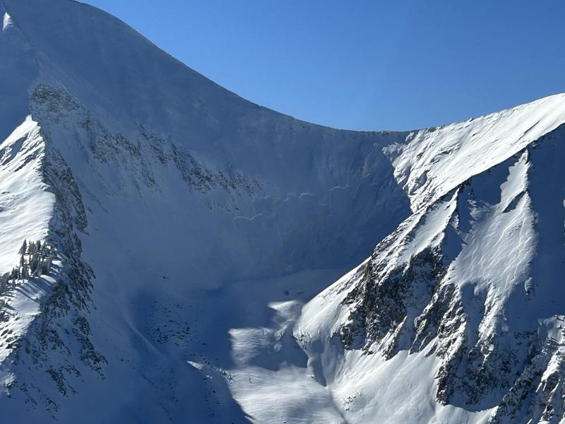
This natural avalanche likely occurred during the height of the storm Wednesday night. For a detailed description go here.
Dave Garcia photo.
Ad
Avalanche Problem #1
Persistent Weak Layer
Type
Location
Likelihood
Size
Description
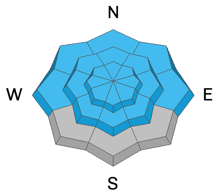
A persistent weak layer of faceted snow that developed during the cold dry period in mid November is now present on all aspects. The condition is most dangerous and wide spread on slopes facing the north half of the compass, where wind drifted snow has built thick slabs on top. Observers yesterday also reported collapsing on southwesterly aspects so south facing slopes can't be ruled out. This persistent weak layer is settling in and will be with us for awhile so plan on avoiding slopes steeper than 30 degrees, especially those that face W-N-E, for the foreseeable future.
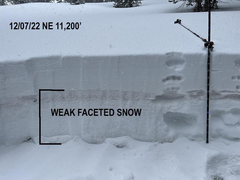
Photo illustrates the obvious poor snowpack structure. As more snow is piled on top, stress on the weak snow will increase, as will the likelihood of triggering deeper and more dangerous avalanches.
Avalanche Problem #2
Wind Drifted Snow
Type
Location
Likelihood
Size
Description
Blowing and drifting snow is creating fresh slabs on northerly aspects. Though fresh deposits of wind drifted snow are a concern, the primary issue is continued loading on the buried persistent weak layer. Avoidance of steep, northerly facing slopes is the only realistic strategy.
Additional Information
If you are getting up into the mountains please submit an observation and let us know what you are seeing!
This detailed snowpit illustrates my findings on a NE aspect at 11,200'.
General Announcements
This forecast is from the U.S.D.A. Forest Service, which is solely responsible for its content. This forecast describes general avalanche conditions and local variations always occur. This forecast will be updated by 7:30 tomorrow morning.