Join us at our 2nd Annual Blizzard Ball

Forecast for the Salt Lake Area Mountains

Trent Meisenheimer
Issued by Trent Meisenheimer on
Saturday morning, April 9, 2022
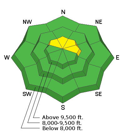
Today we have a MODERATE avalanche danger on slopes facing northwest, north, northeast, and east at the upper elevations for fresh drifts of wind-blown snow. We have a LOW avalanche danger on all other slopes where you should use Normal Caution.
Risk is inherent in mountain travel, and even a small avalanche can lead to a bad outcome in radical terrain.
Low
Moderate
Considerable
High
Extreme
Learn how to read the forecast here
Special Announcements
Snowbasin Ski Patrol is holding an avalanche dog fundraiser on Saturday, April 9th from 6-10pm at Mountain Luxury Real Estate, 3632 N Wolf Creek Drive in Eden, UT. The event costs $20 and includes dinner and a silent auction. Find more information HERE.
Weather and Snow
Last night around 10:00 pm, the winds picked up and are currently blowing from the west-southwest at speeds of 10-15 mph with gusts into the 20's & 30's across the upper elevations as a dry cold front crosses over northern Utah. Above 10,500', the winds are blowing from the west at 25-30 mph, gusting into the 50's. Mountain temperatures remain warm, with overnight lows in the upper 30's to low 40's °F across almost all elevations.
Today we will see mostly cloudy skies and mountain temperatures cooling throughout the day. The 700 millibar (10,000') temperature drops to -2°C (28°F) by noon. Winds will remain elevated throughout the day and will continue to blow from the westerly direction at speeds of 10-20 mph with gusts into the 20's & 30's.
This week winter will return to northern Utah as a robust storm system will impact us starting Monday. By Wednesday we could see 14-22 inches of new snow.
Recent Avalanches
No new avalanches were reported yesterday.
Ad
Avalanche Problem #1
Wind Drifted Snow
Type
Location
Likelihood
Size
Description
Many surfaces won't have any snow to blow around and drift because they are frozen this morning and there is no snow available for transport. However, dry, cold powder remains on northerly facing slopes above about 9,000' in elevation, and these would be the slopes I would suspect to find some wind drifted snow on.
Be on the lookout for snow that is actively being drifted by the wind and avoid areas that look pillowy and rounded. Wind drifted snow can also feel stiff/hard and hollow like a drum.
Avalanche Problem #2
Normal Caution
Type
Location
Likelihood
Size
Description
Is the snow surface frozen? Good question. Overnight and current mountain air temperatures hover in the upper 30's & low 40 °F across all elevations. This morning, the Atwater mountain weather station (8,752') records a current snow surface temperature of 28.8°F. The current 700 millibar (10,000') temperature is 35°F, and by noon this temperature is forecast to drop to 28°F. We are also expecting plenty of wind and cloud cover throughout the day.
Therefore, my bet is the snow surface overnight has had a shallow refreeze, and throughout the day today, as the temperatures continue to cool, we won't see wet snow avalanches. However, it's always best to evaluate the snow as you travel, and if you find yourself in wet and unsupportable snow, it's time to head home or change your aspect. Use Normal Caution today.
General Announcements
Who's up for some free avalanche training? Get a refresher, become better prepared for an upcoming avalanche class, or just boost your skills. Go to https://learn.kbyg.org/ and scroll down to Step 2 for a series of interactive online avalanche courses produced by the UAC.
This information does not apply to developed ski areas or highways where avalanche control is normally done. This forecast is from the U.S.D.A. Forest Service, which is solely responsible for its content. This forecast describes general avalanche conditions and local variations always occur.