Fall Auction is now live! Check it out now

Observation: Lambs Canyon

Observation Date
3/10/2022
Observer Name
Staples, Brackelsberg, Grewe
Region
Salt Lake » Parleys Canyon » Lambs Canyon
Location Name or Route
Lambs Canyon/Mt Aire
Weather
Sky
Clear
Wind Speed
Calm
Weather Comments
Warm in the sun. Cold in the shade.
Snow Characteristics
New Snow Depth
9"
New Snow Density
Medium
Snow Surface Conditions
Powder
Red Flags
Red Flags
Recent Avalanches
Cracking
Collapsing
Poor Snowpack Structure
Avalanche Problem #1
Problem
Persistent Weak Layer
Trend
Same
Problem #1 Comments
This problem is with us for the near future. Very cold temps last night and today, but there should be much warmer air temperatures this weekend. The main thing is that the slab of snow on top of this weak layer will be settling and consolidating and becoming more cohesive. At the same time, the weak layer will be adjusting to the load on top of it VERY VERY SLOWLY. I honestly can't say how likely it will be to trigger avalanches on this PWL, but it will probably remain unstable through the weekend at a minimum.
KEY POINT - If you see someone riding a slope without triggering it, one of two things may be in play (1) they just got lucky (luck is a bad risk management strategy), or (2) the slope they are riding does not have this weak layer. Personally, I would assume any north, east, or west facing slopes have this weak layer lurking beneath.
If for some reason this layer doesn't exist on on slope, it may be on an adjacent slope. If for some reason it doesn't exsit on part of a slope, it may exists on another part of the same slope.
Snow Profile
Aspect
Northwest
Elevation
7,900'
Slope Angle
30°
Comments
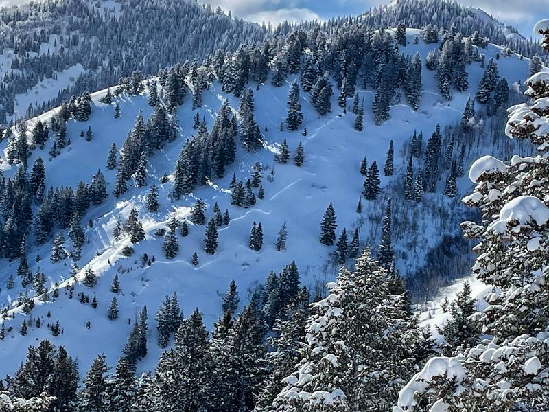
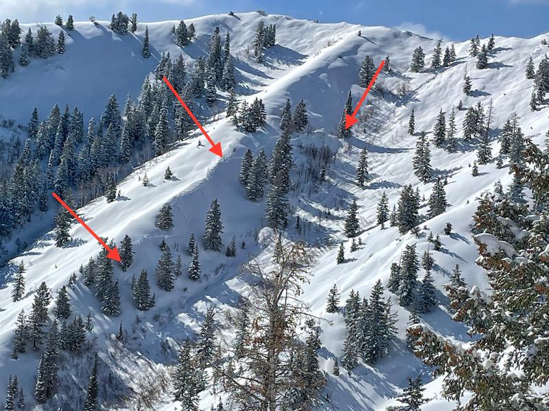
We spotted two large natural avalanches (this one and this one). We decided to look at the snow on a similar aspect and elevation. First we dug near the ridgeline and didn't find an obvious faceted layer or an unstable looking snowpack, so we moved to a slightly more sheltered location just a tiny bit further downhill becuase the avalanches had happened a little distance below ridgelines.
This is a scary situation. Sure enough, as soon as we reached the top of a clearing (30 degrees in steepness at the top but steeper below us), we triggered two collapses and cracks shooting about 50 ft in front of us. THIS MEANS we would have triggered a slide if we had moved onto the steeper part of the slope. In fact, I'm a little surprised we didn't trigger the slope below us.
Below is a photo of the pit wall where we recorded the snow profile. The second photo shows how the snow fractured on the facets as we filled in our snow pit.
Below are photos of the two natural avalanches.
Today's Observed Danger Rating
High
Tomorrows Estimated Danger Rating
Considerable
Coordinates