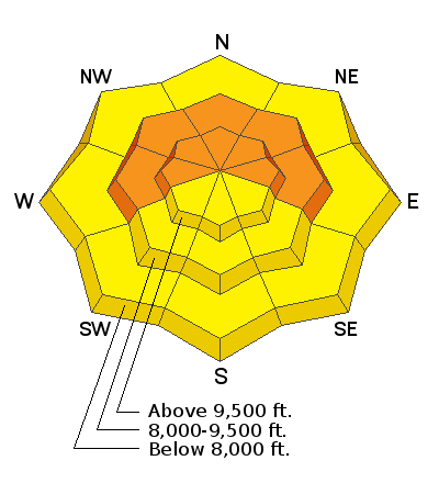
The Provo mountains received another 3-6" overnight with storm totals of about 12"/1.0"SWE.
Mountain temperatures are in the single digits and working their way toward 0°F
The east northeast winds are blowing 20-30mph with gusts to 35.
If we're lucky, we'll squeeze another 1-3" out of this storm before it moves on. Winds will shift to the northwest and diminish by midday; temps will drop to the low single digits and below.
Skies will start to trend mostly cloudy this evening with some clearing for tomorrow ahead of a weak disturbance tomorrow night into Friday. Clear and warm for the weekend.
Our snowpack has begun to tip its hand. We didn't hear of any avalanches in the Provo mountains, but activity noted below in the central Wasatch mirrors what I expect in the Provo mountains.
We had not one but three canaries in the coal mine yesterday. In other words, we had *just* enough new snow and *just* enough wind to start to develop a slab over our widely advertised Jan/Feb drought layer. And overnight we've added more snow and more wind.
Kessler Peak of BCC: 9600' NE facing. A skier collapsed the slope and triggered a 12" deep and 20' wide pocket while ascending the Patterson ridge and was nearly caught in the slide.
Broads Fork of BCC: 9400' NE facing A skier remotely triggered a 10" deep and 40' wide from 15' away
Mill B South of BCC: 8500' East facing A skier unintentionally triggered an 18" deep and 20' wide pocket in steep rocky terrain
(We very much appreciate these key observations/reports. Many can be found on our Avalanches and Observations page in the menu above.)
Otherwise, we had more reports of sluffing in the low density snow in the steeper terrain.


