UDOT PLANNED AVALANCHE CLOSURES!!

Observation: Moonlight

Observation Date
2/21/2022
Observer Name
Champion
Region
Salt Lake » Big Cottonwood Canyon » Mineral Fork » Moonlight
Location Name or Route
Mineral - Low East Facing
Weather
Sky
Overcast
Precipitation
Light Snowfall
Wind Direction
West
Wind Speed
Light
Weather Comments
Light snowfall, primarily S1, and overcast skies all day. During any periods of lighter snowfall (S-1) the cloud deck would rise, we could make out the other side of the canyon and see an outline of the sun through the clouds. Temperatures were cold to moderate, hovering in the upper teens in Mineral Fork, but felt could with the moisture in the air.
Snow Characteristics
New Snow Depth
4"
New Snow Density
Low
Snow Surface Conditions
Powder
Snow Characteristics Comments
At 6:30 AM, the trailhead had about 1-2" of new low-density snow that begin early that morning. The snowfall continued throughout the day with anywhere between 3-5" of new snow by 4:30 PM. The new snow was not bonding well to the old snow surface or the density change between storms.
Overall the new snowfall greatly improved riding conditions, but in any areas that held a firm crust from wind or sun, the surface was still very present and the new snow easily sluffed off it while touring or while riding downhill.
Red Flags
Red Flags
Recent Avalanches
Cracking
Poor Snowpack Structure
Red Flags Comments
By the end of the day, the snow sensitivity had risen greatly. Around 4:00 PM it was easy to kick off sensitive soft slab avalanches within the new snow failing on a density change between storms. While these were not large, and could not bury anyone outside of a serious terrain trap, they were touchy and could easily knock someone off their feet and through complex terrain. Where we dug, on an East facing aspect near 8000', the snowpack was 110cm deep and entirely faceted below the new snow. We were unable to get any results within our pit, but the entire snowpack structure is garbage once we get a slab.
Comments
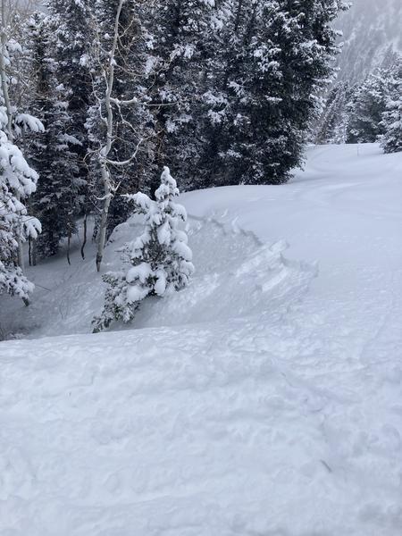
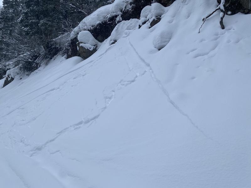
Went out for a quick tour up the low east-facing ramp of Mineral Fork. The snowfall was consistent throughout the entire day, and overall improved the riding conditions and the travel conditions. Old skin tracks and ski tracks were still very visible, but getting nicely filled in by the end of the day. With the snowfall, came obvious signs of instability throughout the day including cracking. By the late afternoon, you could trigger a small soft slab avalanche on any steep rollover. These avalanches were shallow, failing only 3-5" deep on the new snow, old snow interface, but still sensitive and fast-moving. Beyond the new snow instabilities, I did not see any signs of obvious transport or loading coming from the winds, or any signs of the shallow soft slabs stepping down more deeply into any faceted snow.
We only put our shovels in, on the east-facing terrain, and when we did we found an entire snowpack of facets. While this is not currently an issue, it will become an issue once we eventually get a slab on top of it.
Attached below is a small soft slab avalanche triggered into a steep terrain trap.
Today's Observed Danger Rating
Moderate
Tomorrows Estimated Danger Rating
Low
Coordinates