Join us at our 2nd Annual Blizzard Ball

Forecast for the Moab Area Mountains

Eric Trenbeath
Issued by Eric Trenbeath on
Monday morning, January 24, 2022
The avalanche danger is LOW on all aspects and elevations and generally stable snow conditions exist. Watch for unstable snow on isolated terrain features, particularly in areas of steep, rocky, extreme terrain.
Hard snow conditions exist and dangerous "slides for life" are possible. Be mindful of your exposure on steep slopes with firm snow, and consider carrying a tool for self arrest in the high country.
Low
Moderate
Considerable
High
Extreme
Learn how to read the forecast here
Special Announcements
Road Conditions: The road to Geyser Pass Trailhead is dirt and mud down low, snow packed and icy above. AWD and good tires are recommended.
Grooming: LUNA last groomed all trails on Thursday.
Weather and Snow
24 Hour Snow 0" 72 Hour Snow 0" Base Depth in Gold Basin 41" Wind NW 20-25 G40 Temp 20
Sitting on the front side of a ridge off the Pacific coast, we will remain under a mostly dry northwesterly flow through the week. A weak, shortwave trough affecting mainly northern Utah will drop SE through Colorado tonight bringing us clouds and a slight chance for snow showers. Clouds will linger into Tuesday before clearing out later in the day. Dry and sunny conditions return for the remainder if the week.
NWS Weather Forecast for the La Sal Mountains
Gold Basin SNOTEL site (10,000')
Storm Totals in Gold Basin
Wind Station on Pre Laurel Peak (11,700')
Snowpack
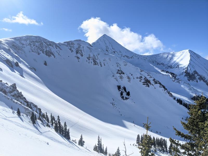
Observations from the weekend report widely variable snow surfaces ranging from isolated areas of soft snow, to varying thicknesses of wind and sun crusts, to even ice and rock hard wind board. A few shallow, isolated wind slabs were also observed amongst the otherwise wind blasted and sun crusted surfaces. On sheltered shady aspects, snow at or near the surface is becoming loose and weak. This is something to keep an eye on when new snow finally comes. The buried persistent weak layer of faceted snow at the base of the snow pack has gone largely dormant, and it seems like we can put this problem to bed for awhile. This doesn't mean it no longer exists, or that you can't trigger an avalanche on it, but the odds at this point are extremely unlikely. Northerly aspects with thinner snowpack areas, and very steep, rocky, radical terrain are the most suspect.
On the bright side, avalanche conditions are generally stable, and sunny blue skies make for brilliant days in the mountains. It's a good time to get out and explore or maybe bag a winter ascent of a peak that's been on your list. Be advised however that slick hard surfaces abound. Be mindful of exposure and carry a tool for self arrest.
A bluebird day in the alpine beats a day almost anywhere else, even with variable conditions! Travis Nauman photo.
Recent Avalanches
No new avalanches have been reported since the Dec 31 avalanche cycle. Go here for the complete list.
Ad
Avalanche Problem #1
Normal Caution
Type
Location
Likelihood
Size
Description
Though the avalanche danger is low and generally stable conditions exist, here are some things to keep in mind:
  • A persistent weak layer of loose, sugary, faceted snow exists at the base of the snowpack on northerly aspects. This weak layer produced a widespread cycle of very large, deep, and dangerous avalanches on December 31. Over time, this weak layer has either gained strength or at least fallen into a state of dormancy. Though currently unlikely, it may still be possible to trigger an avalanche on this weak layer in thin snowpack areas, or on very steep, rocky, extreme terrain.
  • Isolated, unstable areas of wind drifted snow may exist on the leeward sides of ridge crests and terrain features such as sub-ridges and rock outcroppings above treeline. Shallow wind slabs shouldn't pose much of a threat but one could sweep you of your feet and carry you over a cliff, especially if you are stomping around in higher, more extreme terrain. Be wary of smooth rounded deposits, or areas where the snow feels or sounds hollow underneath.
  • Areas of very firm snow exist where a fall could produce a dangerous, slide for life. Be mindful of your exposure on steep slopes with firm snow, and consider carrying a tool for self arrest in the high country.
Additional Information
The beacon training park is up and running above the Geyser Pass Trailhead. Pull out your beacon and practice your skills as you head up the trail! A huge thanks to Talking Mountain Yurts and Moab Gear Trader for their support of this great resource!
General Announcements
Who's up for some free avalanche training? Get a refresher, become better prepared for an upcoming avalanche class, or just boost your skills. Go to https://learn.kbyg.org/ and scroll down to Step 2 for a series of interactive online avalanche courses produced by the UAC.
This forecast is from the U.S. Forest Service, which is solely responsible for its content. This forecast describes general avalanche conditions and local variations always occur.