Fall Auction is now live! Check it out now

Forecast for the Moab Area Mountains

Eric Trenbeath
Issued by Eric Trenbeath on
Wednesday morning, January 5, 2022
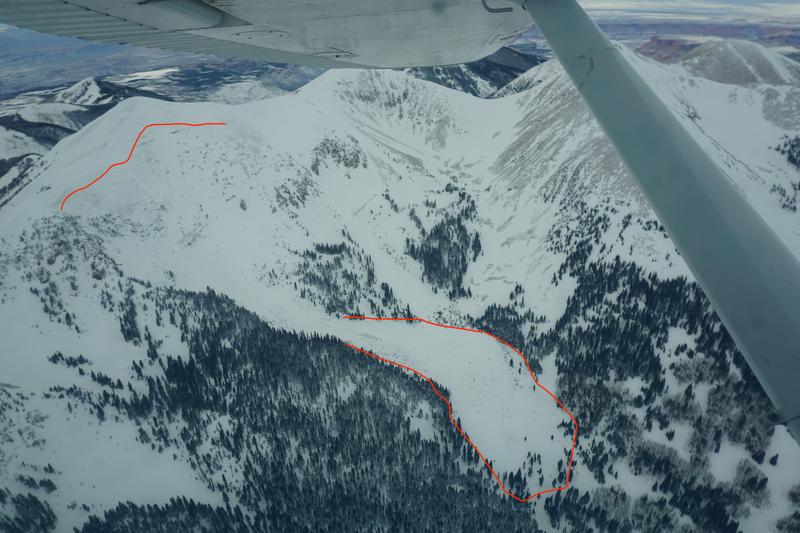
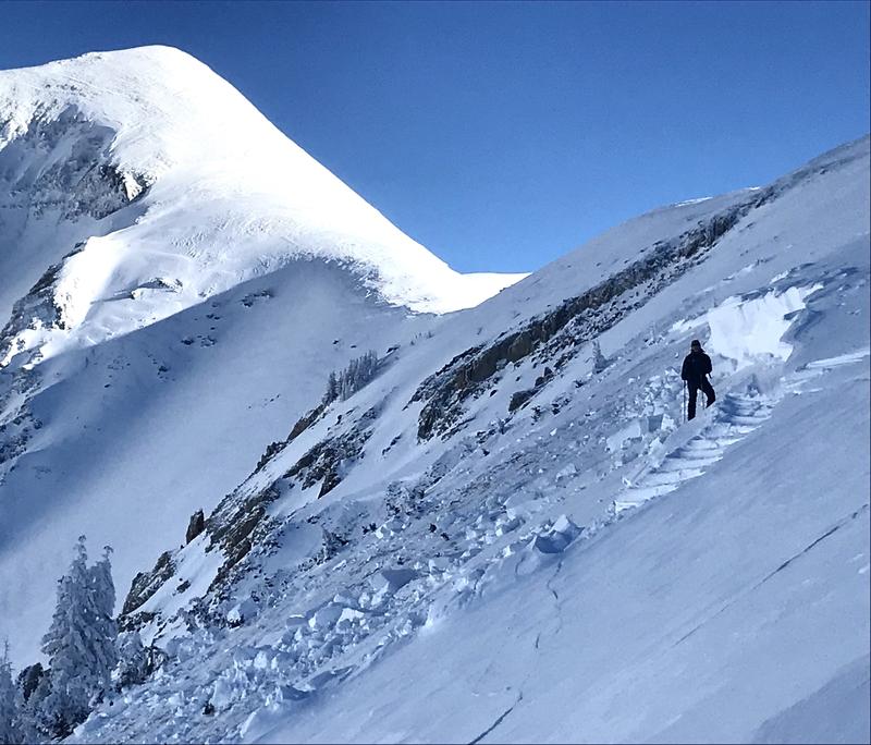
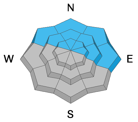
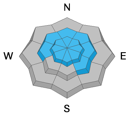
Steady wind loading has kept the danger CONSIDERABLE on steep, upper elevation slopes that face NW through E, and deep and dangerous, human triggered avalanches 3'-5' deep are possible if not likely in these areas.
The avalanche danger is MODERATE on steep, mid and lower elevation north facing terrain, and on slopes facing W-S-SE where you can detect recent deposits of wind drifted snow.
Though the likelihood of triggering a deep and dangerous avalanche is trending downward, keep in mind that most avalanche accidents occur during the period when the danger begins to move between Considerable and Moderate or vice versa. Keep your guard up. A triggered, large avalanche would be unsurvivable.
Low
Moderate
Considerable
High
Extreme
Learn how to read the forecast here
Special Announcements
Road Conditions: Grand County plowed the road to the Geyser Pass Trailhead om Monday!
Grooming: Trees are cut out and packing has commenced. Look for full grooming later in the week,
Weather and Snow
24 Hour Snow 0" 72 Hour Snow 0" Base Depth in Gold Basin 45" Wind WSW 15-20 Temp 27F
Gold Basin SNOTEL site (10,000')
Storm Totals in Gold Basin
Wind Station on Pre Laurel Peak (11,700')
NWS Weather Forecast
Westerly winds continue to blow this morning and they'll be on the increase today as a strong jet stream with northwest flow aloft bring heavy snow to northern Utah and Colorado. Today, we'll see breezy conditions, partly sunny skies, and highs in the mid 20's. The next system over the weekend doesn't look too promising, nor do long range model runs through mid month.
Snowpack
The main thing that stood out in our travels in Gold Basin yesterday was the effects of the wind. Blowing and drifting snow continued to load upper elevation north, and particularly northeast aspects. Exposed areas were scoured and textured, and thin wind crusts have formed as well. Good, settled powder can still be found in sheltered areas below treeline.
The dust has settled from last Friday's avalanche cycle which entailed dozens of deep, hard slab avalanches failing on a persistent weak layer of of sugary, faceted snow at the base of the snow pack, the result of early season, mid-October snow. Stability tests performed yesterday show that an avalanche of this size will be harder to trigger now, but if you did trigger one it would be a monster. Likely trigger points include shallow, rocky areas, lines along slope margins, or on steep convexities. Wth avalanches of this magnitude remaining a real possiblity, I would give things a little more time before stepping out on to steep, northerly facing terrain.
Aerial observer Chris Benson was out flying around yesterday and sent in this observation with pictures noting the effects of the wind. Brian Hays was also up and sent in this observation.
Westerly winds yesterday made for continuous wind loading on upper elevation, north and northeast aspects. Brian Hays photo.
Recent Avalanches
Observers continue to report widespread, deep, and very large natural avalanches on northerly aspects from Friday's storm event. Aerial observer Chris Benson spotted this large avalanche in Beaver Basin yesterday. Go here for the complete list of avalanches from the December 31 cycle.
Beaver Basin avalanche. Chris Benson photo.
Horse Creek Avalanche. Brian Murdock photo.
Ad
Avalanche Problem #1
Persistent Weak Layer
Type
Location
Likelihood
Size
Description
A heavy load of recent, and wind drifted snow has been added to a pre-existing slab on top of a persistent weak layer of loose, sugary, faceted snow at the base of the snowpack. This has resulted in widespread natural avalanche activity on northerly aspects. The recent load has provided quite a thump, and as the dust settles so to speak, we should see a trend towards greater stability. With the magnitude of these avalanches, however, we need to give things some time. It is still possible if not likely to trigger one of these monsters. Likely trigger points include shallow, rocky areas, along slope margins, or on steep convexities.
Avalanche Problem #2
Wind Drifted Snow
Type
Location
Likelihood
Size
Description
Increased south and westerly winds have created fresh deposits of wind drifted snow on northerly aspects. Shifting wind directions since Friday's storm have blown and drifted snow on to all aspects near and above treeline. Older wind slabs have likely gained strength over the past few days, but you may still find some sensitive to the weight of a skier or rider lurking just about everywhere in wind exposed terrain. Wind slabs form on leeward slopes just below ridge crests. They can also be found on the leeward sides of terrain features such as sub ridges, gully walls, and rock outcroppings. Fresh drifts are recognizable by their smooth, rounded appearance, and cracking is a sign of instability. On northerly aspects, wind drifted snow has added stress to older slabs on top of a buried persistent weak layer and dangerous, human triggered avalanches 3'-5' deep are possible. Avoid steep, wind drifted slopes.
General Announcements
Who's up for some free avalanche training? Get a refresher, become better prepared for an upcoming avalanche class, or just boost your skills. Go to https://learn.kbyg.org/ and scroll down to Step 2 for a series of interactive online avalanche courses produced by the UAC.
This forecast is from the U.S. Forest Service, which is solely responsible for its content. This forecast describes general avalanche conditions and local variations always occur.