

Observation Date
12/28/2021
Observer Name
Derek DeBruin & Marissa Popp
Region
Ogden » Ben Lomond » Cutler Ridge
Location Name or Route
Ben Lomond, Cutler Ridge
Comments
We poked in the snow in a number of places in the low and mid elevations. Low elevation snow depth is 50-60cm with a stout (3-8cm) crust near ground level amongst the bushes and more or less rightside up, softer snow above. Hand shears showed decent bonding throughout the lower elevation snowpack. This would probably be great, safe riding terrain if there was less exposed vegetation on the surface.
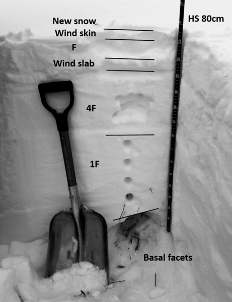
The mid elevations hold 80-90cm of snow in most locations. However, what is particularly noteworthy is the spatial variability of the faceting problem, leading me to significant uncertainty. While most snow depth seemed to be in the 80-90cm range, we found some shallower pockets (~60cm) that could probably be explained by local factors, but were quite surprised to find a mere 40cm of snow at 8200ft on a NE aspect sitting on what was presumably bare ground (no facets present).
With the exception of the basal facets, the snowpack is mostly rightside up. The example pictured below is from approx 7800ft NE facing near the weather station. Layering from the recent storms and wind events was clear, but bonding was generally decent between contiguous layers. Medium to hard shovel shears in this pit eventually caused separation between successive storm layers, but required a fair amount of effort to produce. We found ECTN23 down 15cm, but did not get any propagation on the remaining 7 taps. We found similar structure at 8000ft NW facing and 8200ft N facing with the only varabiality being the thickness of the wind layers.
In the 8200ft pit, shovel shears were similar. We had a CT11 that failed on the basal facets. We also got an ECTN17 result down 20 on the same layer we found in the 7800ft pit. Subsequent ECTs yielded an ECTN18 but also an ECTP29 on the basal facets. Also of note was the variability of the basal snow. In some places there was decomposing crust to accompany the facets, in others none (this seemed to vary with nearby buried vegetation). At 8000ft and below, facets might be rounding and damp. Facets ranged in size from 1 to 3mm, and we found the clear striations of depth hoar in some spots, and even the occasional bit of chaining in one location, but in others a mixed bag of angulated facets and rounding facets.
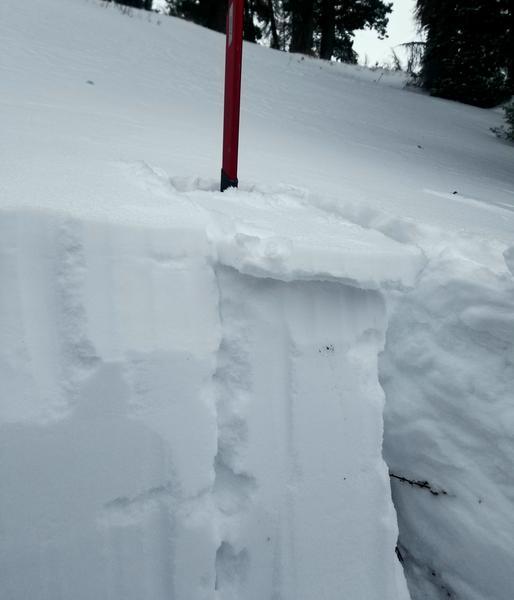
Add to this a recent 7800ft NE ECTX and not too many large results with inbounds control work. See the second photo below where poorly bonded wind skin slid off the top of the column the moment the shovel touched it upon isolation, much more reactive than any other shears of the day.
Synthesizing this, I suspect that there is likely some pretty safe steeper riding up to 8500ft, but at the moment I have no idea where it is precisely. Seeing poor structure, depth hoar, an ECTP, and a touchy surface wind layer one the shovel shear provides me just enough contrary evidence to consider nothing trustworthy, unfortunately, with compelling evidence required on a slope-by-slope basis.
Today's Observed Danger Rating
None
Tomorrows Estimated Danger Rating
None
Coordinates