Sign Up for the Utah Snow and Avalanche Workshop (USAW) on December 7th!

Forecast for the Salt Lake Area Mountains

Trent Meisenheimer
Issued by Trent Meisenheimer on
Monday morning, December 27, 2021
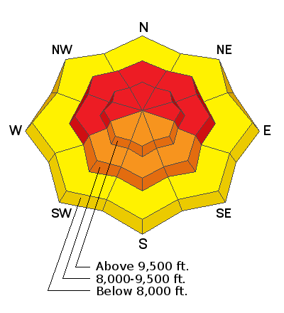
The avalanche danger is HIGH on mid and upper elevation aspects facing west through north and east, where strong winds and recent snowfall have created dangerous avalanche conditions. Both natural and human-triggered avalanches are likely. Traveling in or below avalanche terrain is not recommended.
There is a CONSIDERABLE avalanche danger on mid and upper elevation aspects facing southwest, south and southeast. Low elevations have a MODERATE avalanche danger.
Low
Moderate
Considerable
High
Extreme
Learn how to read the forecast here
Avalanche Warning
THE AVALANCHE DANGER IS HIGH WITH DANGEROUS AVALANCHE CONDITIONS.
AN AVALANCHE WARNING HAS BEEN ISSUED FOR THE MOUNTAINS OF MUCH OF THE STATE OF UTAH, INCLUDING THE WASATCH RANGE...BEAR RIVER RANGE...UINTA MOUNTAINS...AND THE MANTI-SKYLINE.
HEAVY DENSE SNOWFALL AND STRONG WINDS HAVE CREATED DANGEROUS AVALANCHE CONDITIONS. BOTH HUMAN TRIGGERED AND NATURAL AVALANCHES ARE LIKELY. STAY OFF OF AND OUT FROM UNDER SLOPES STEEPER THAN 30 DEGREES.
Weather and Snow
Yesterday's impressive cold front came roaring through the valley and slammed into the Wasatch front delivering strong winds and impressive snowfall rates. In the past 24 hrs, we've seen roughly 6" to 15" inches of new snow containing 0.50" to 1.84" of water throughout the mountains.
The National Weather Service has issued another Winter Weather Advisory that will be in effect at 8:00 am this morning. The strongest snowfall will occur late in the day as another cold front crosses northern Utah. We could pick up another 1-2 feet of snow by tomorrow morning.
Currently, the upper elevation mountain temperatures are in the low teens °F, while lower in the canyon; the temperature hovers in the mid-teens °F. The wind remains the headline news and continues to blow from the southwest 15-30 mph with gusts into the 30's, 40's and 50's across the upper elevations.

You can get caught up by reading our Week in Review where we summarize significant snow and weather events from this past week.
Recent Avalanches
Yesterday, ski areas reported triggering large avalanches with explosives (results below). Upper Little Cottonwood reported a natural avalanche cycle at some point in the morning. Snowbird got a quick look into Whitepine Canyon and reported that most of the Whitepine ridge had avalanched. Backcountry observers continue to report unstable, poor snowpack structure and cracking/collapsing within the snowpack.
  • Upper Big Cottonwood: northeast-facing 9,500' in elevation. 300-500 feet wide running 1,000.'
  • Upper Big Cottonwood: two avalanches failing into the Persistent Weak Layer (PWL). Both were large enough to catch, carry, bury, and kill a human.
  • Upper Little Cottonwood: west-facing 10,500' in elevation. 350 feet wide, 2-6 feet deep. Also reported several other avalanches breaking into faceted snow (PWL).
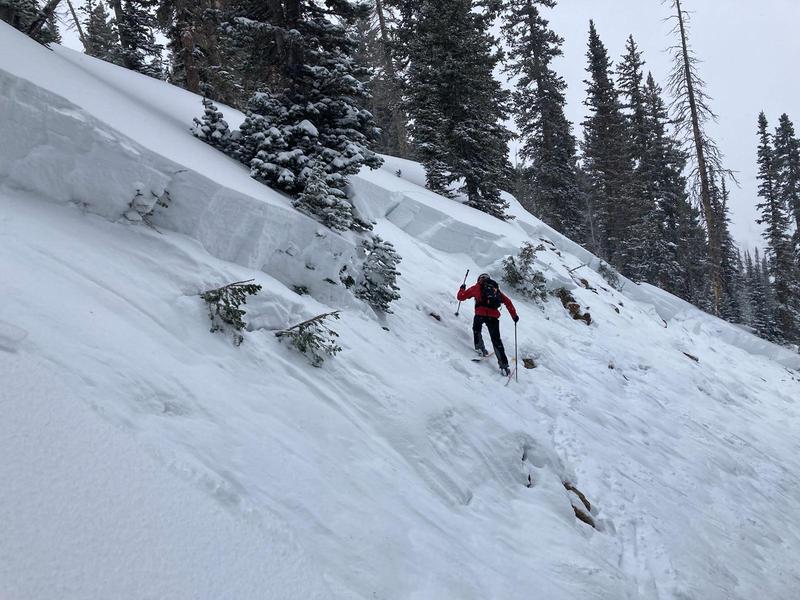
  • Upper Little Cottonwood: northeast-facing 9,400' in elevation. 200-400 feet wide, 4-6 feet deep (picture below).
Ad
Avalanche Problem #1
Persistent Weak Layer
Type
Location
Likelihood
Size
Description
Heavy snowfall and strong winds continue to overload a buried persistent weak layer of faceted snow down near the ground. This layer exists on mid and upper elevation aspects facing west through north and east. Avalanches failing on this weak layer may be triggered remotely (from a distance) or below. Any avalanche failing on this layer may break down 2-6' deep (possibly deeper), propagate hundreds of feet wide, and run downhill thousands of feet.
Traveling on or below slopes approaching 30 degrees or steeper is NOT recommended.
Look at the picture in recent avalanches if you're confused by how serious this problem is. Now imagine all that snow instantly moving 30-60 mph downhill with you completely submerged and out of control. You go to take a breath; all you manage to do is inhale the snow, clogging your mouth; you can't breathe. You'll be lucky to be alive when the avalanche comes to a stop (all it takes is one tree, then it's lights out). Sure rescue gear might save you, but it might not. This avalanche problem is the real deal and should be avoided with large safety margins. Avoidance is the key.
Avalanche Problem #2
Wind Drifted Snow
Type
Location
Likelihood
Size
Description
Strong winds have created both hard and soft slabs of windblown on all aspects at the mid and upper elevations. Although the winds have been mainly from the west/southwest, winds this strong can channel snow around terrain features and create fresh drifts on all aspects, including well-down off of ridge lines. You may even find fresh wind drifts at unusually low elevations below 8,000'.
Avalanche Problem #3
New Snow
Type
Location
Likelihood
Size
Description
New snow soft slab avalanches will be particularly sensitive during high snowfall rates. Natural avalanches may be possible in the steepest terrain. Avalanches may also be triggered at a distance during this time.
General Announcements
Who's up for some free avalanche training? Get a refresher, become better prepared for an upcoming avalanche class, or just boost your skills. Go to https://learn.kbyg.org/ and scroll down to Step 2 for a series of interactive online avalanche courses produced by the UAC.
This information does not apply to developed ski areas or highways where avalanche control is normally done. This forecast is from the U.S.D.A. Forest Service, which is solely responsible for its content. This forecast describes general avalanche conditions and local variations always occur.