

Observation Date
12/14/2021
Observer Name
R. Kosinski
Region
Salt Lake » Big Cottonwood Canyon » Butler Fork
Location Name or Route
Butler Fork
Comments
Started my tour around noon under warm and windy overcast skies. Starting around 12:30, winds increased greatly and were moderate gusting strong at mid elevations and sounded like a hurricane or jet plane at high elevations. Snowfall started around this same time and varied between light and moderate during the afternoon. As the front of the storm moved through out of the south, temps rapidly dropped and the cloud ceiling at times lowered to below 10k'.
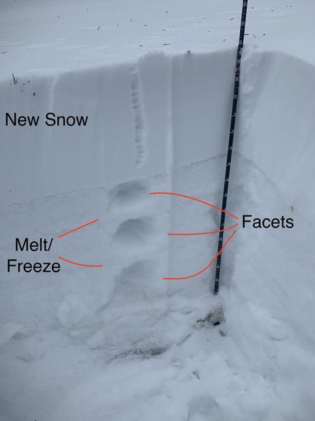
I toured up into one of the small basins to the southeast of Gobblers Knob. Snow depth ranged from 15cm to 100cm in sheltered areas. There was little to note until I arrived in a small clearing at 8700' facing north. As I got to the middle of this 200'x 75' clearing there was a very loud and large collapse. I dug a pit in this area, which is sheltered and held more snow than surrounding areas.
95-65 cm: new snow, 3 finger hard, consolidated and cohesive within layer
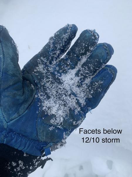
50-65cm: facet layer, this is what avalanches are running on (see picture)
45-50cm: melt-freeze crust
37-45cm: facet layer
33-37cm: melt-freeze crust
15-33cm: facet layer (facets were larger than in other layers)
0-15cm: ice layer
I performed a shovel pull/shear test on the new snow/old snow interface which showed a very reactive and cohesive layer with moderate energy.
I went out today fully expecting to see some concerning avalanche conditions. After seeing how reactive and poorly set up the snowpack is my recommendation is to familiarize yourself with the <30 degree slopes & areas with no PWL, and be very weary of overhead hazard and interconnected slopes. Based on the forecast and what I saw today, I would suspect that we will be moving into the high danger category tomorrow as new snow overloads the PWL in some areas and large, sensitive windslabs form tonight.
Today's Observed Danger Rating
Considerable
Tomorrows Estimated Danger Rating
High
Coordinates