March Kicks Off Our Spring Campaign- Donate Now to Support Forecasting

Forecast for the Uintas Area Mountains

Craig Gordon
Issued by Craig Gordon on
Monday morning, March 29, 2021
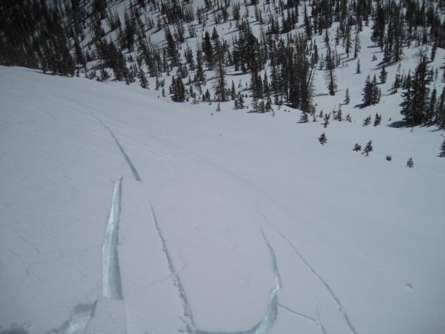
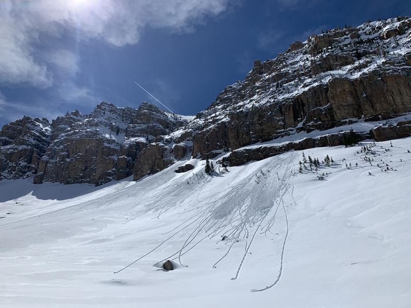
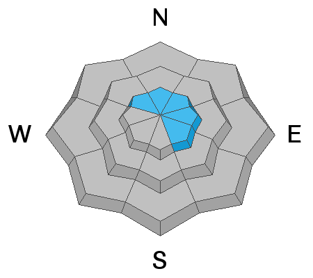
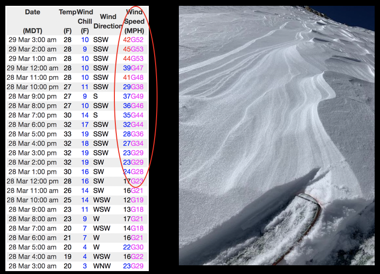
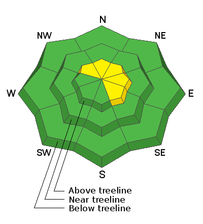
While not widespread and isolated to high alpine terrain, today you'll find pockets of MODERATE avalanche danger above treeline in the wind zone. Human triggered slides are possible on steep, wind drifted, leeward slopes facing the north half of the compass.
And remember... triggering even a small slide in steep, unforgiving terrain can deliver a season ending injury if you slam into a tree or get carried over a cliff band.
Lose the wind and you lose the problem. Mid and low elevation terrain offers generally LOW avalanche danger.
Low
Moderate
Considerable
High
Extreme
Learn how to read the forecast here
Special Announcements
Our Spring Avy Awareness Campaign is in full swing from March 16th- March 30th. Please help us save lives through avalanche forecasts and education. Consider making a donation to show your support.
Weather and Snow
Nowcast-
A big, bright, beautiful "worm" moon wanes, as clouds patiently wait in the wings to slide into the region just after sunrise. In the meantime, west and southwest winds blow in the 40's and 50's along the high ridges and temperatures register in the low to mid 30's. Riding and turning conditions are gonna take a hard hit... maybe get on that garage cleaning project you've been waiting patiently to jump on.
Forecast-
Very strong west and southwest winds blow in the 70's and 80's along the high peaks as an unusually strong cold front slams into the eastern front. We've already reached the warmest part of the day and temperatures crash into the teens by mid afternoon. Clouds increase and scattered snow showers develop, but only add up to trace... perhaps a couple of traces. Skies clear this afternoon, winds diminish, and temperatures crash into the single digits.
Futurecast-
High pressure with clear skies and slowly warming temperatures are on tap for Tuesday. We break out of the deep freeze Wednesday through Friday with nearly record setting temperatures on tap by the weekend.
Looking for real-time temps, snow, or wind?
Click HERE and then on the "western Uinta" tab for western Uinta specific, weather station network.
Recent Avalanches
Ted was in the high alpine terrain around Lofty Lake Peak Saturday and found pockety wind slabs on steep, leeward slopes. More on Ted's travels and his great insight found HERE.
Whlist, Weston Shirey was in the big terrain around Reids Peak yesterday and found a couple damp rollers, but mostly stable snow and has a most excellent ob HERE.

Observations, trip reports, and avalanches found here.
Ad
Avalanche Problem #1
Wind Drifted Snow
Type
Location
Likelihood
Size
Description
The image on the left represents a 24 hour data dump from Windy Peak (10,661') clearly showing an uptick in winds throughout the night. The image on the right is a result of powder ruining gusts, etching snow on the windward side of the slope and delivering it to leeward terrain facing the north half of the compass..
It never ceases to amaze me how wind can find what little snow there is to blow around and form drifts that cling to terrain features like leeward slopes, chutes, and gullies.
Isolated to steep terrain in the wind zone, today you'll find a stiff, fresh wind drift or two that'll react to our additional weight. Not particularly widespread, but remember... if you're tagging steep, technical terrain, be aware that even a small slide could knock you off your feet and boss you around. So, the ticket to riding safely today is simply look for and avoid any fat, rounded piece of snow, especially if it sounds hollow like a drum
Additional Information
On Friday, Ski-Doo pro rider Steve Martin found shallow pow and excellent riding conditions around Ruth Lake. He's got a great observation posted HERE.
I will update this forecast by 7:00 AM tomorrow, Tuesday, March 30th.
Your observations are important, so please let me know what you're seeing... click HERE and contribute to this amazing community based program
General Announcements
If you see or trigger an avalanche or just wanna let me know what you're seeing you can reach me directly at 801-231-2170 or [email protected]
This forecast is from the U.S.D.A. Forest Service, which is solely responsible for its content. This forecast describes general avalanche conditions and local variations always occur.