Join us at our 2nd Annual Blizzard Ball

Forecast for the Salt Lake Area Mountains

Trent Meisenheimer
Issued by Trent Meisenheimer on
Tuesday morning, March 23, 2021
The avalanche danger is LOW this morning on all aspects and elevations as we generally have safe avalanche conditions. Watch for small isolated soft slabs and sluffing (dry loose avalanches) within the new snow. Terrain selection is essential when dealing with small avalanches.
If we see an increase in northeast winds, then the avalanche danger will quickly rise to MODERATE at the upper elevations for fresh slabs of wind drifted snow, and human-triggered avalanches will be possible.

It's spring, and the weather can change rapidly. Be ready to alter your plans based on changing conditions that you observe in your travels.
Low
Moderate
Considerable
High
Extreme
Learn how to read the forecast here
Special Announcements
The 2021 Spring Awareness Campaign is underway. Help us save lives through avalanche forecasts and education. Consider making a donation to show your support HERE.
Weather and Snow
This morning under clear skies, the mountain temperatures are in the single digits to low teens °F above about 7,000' in elevation. The winds are currently blowing from the northwest at speeds of 5-10 mph, with the occasional gust into the 20's at some upper elevations. Many wind sites are reading speeds that average less than 5 mph.
Clouds once again should fill in over northern Utah this morning as a trough crosses into Nevada. As this trough enters Nevada, it becomes weaker and then re-strengthens over Flagstaff, Arizona, later today, shifting the flow to the northeast with some wrap-around moisture that will likely favor the PC Ridgeline. Unfortunately, the northeast winds are forecast to increase later today and could ruin the powder party. Some wind stations as of 6:00 am are already showing the shift in wind direction to the northeast.
It will be spring weather today with convective showers due to daytime heating, meaning that we could see some periods of heavy snowfall in certain places depending on your location. Some areas could end up with a trace of new snow while others get 2-4" of new snow throughout the day. The good news - the temperatures remain cold, and the clouds should hide the strong March sun keeping the snow cold as well. Gotta love the spring in Utah.
Recent Avalanches
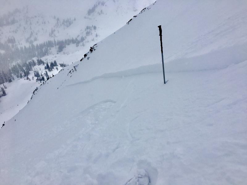
Yesterday one new snow avalanche was reported from Nat Grainger in upper White Pine (picture below). This avalanche was a small soft slab 6-8 inches deep and roughly 100' wide that easily released with a slope cut at their feet.

Ad
Avalanche Problem #1
Wind Drifted Snow
Type
Location
Likelihood
Size
Description
Wind: There are a few things to keep in mind today... First will be the increase in northeast winds. Some stations have already switched wind direction to the northeast as of 6:00 am. If these winds come earlier in the day than expected and, for some reason, blow stronger than expected, then the avalanche danger could quickly rise to moderate. I don't trust northeast winds. For now, winds are calm, and it should be easy to identify if the wind picks up and starts transporting snow. Be willing to change your plan if you see active wind transport.
New Snow: Soft slabs of new snow 6-8 inches deep and up to 100' wide have been reported, and I would be thinking about this in very exposed terrain. In terrain with clean run-outs, these avalanches are not large enough to bury a person, and the consequences are low. However, one of these avalanches could easily sweep you off your feet and take you off a cliff or into rocks, and the consequences will be severe. Slope cuts and small cornice drops effectively test these soft slabs (make sure no one is below).
General Announcements
Please visit this website with information about Responsible Winter Recreation by the Utah Office of Outdoor Recreation.

This information does not apply to developed ski areas or highways where avalanche control is normally done. This forecast is from the U.S.D.A. Forest Service, which is solely responsible for its content. This forecast describes general avalanche conditions and local variations always occur.