Observation: Park City Ridgeline

Observation Date
3/16/2021
Observer Name
E
Region
Salt Lake » Park City Ridgeline
Location Name or Route
Park City Ridge Line
Weather
Sky
Scattered
Precipitation
Light Snowfall
Wind Direction
Northeast
Wind Speed
Light
Weather Comments
Variable Sky conditions throughout the day: Clear to Few to Overcast/Foggy to Scattered to Broken by 1600. The take home was that thankfully it did not greenhouse in the late morning hours when it appeared like it could have happened at any moment. Winds remained Light and variable with mostly an Easterly component until the early afternoon hours when they veered more Northerly. No Wind Blown observed. Temperatures rose rapidly by 1200.
Snow Characteristics
New Snow Depth
10"
New Snow Density
Low
Snow Surface Conditions
Powder
Wind Crust
Melt-Freeze Crust
Damp
Snow Characteristics Comments
6 to 8 inches on the BCC side of the Ridge, and 8 to at least 10 on the PC side of the Ridge. New snow was not blower, but definitely on the Lighter side. There were areas near the Ridge Line that were 4-Finger Hard due to some Wind effect. By 1100 hours the Easterly facing slopes with angles 25 degrees and less were getting damp. By the end of the day, all slopes (besides NNW, N and NNE) got damp and will be crusted in the morning. The Northerly facing slopes needed slope angles greater than 25 degrees to survive the rapid warming and intense March solar. Great powder riding on the slopes that were retaining cold snow. Old tracks, from folks that are riding too late in the day and leaving subsequently frozen ruts, continue to be an issue when we get any new snow. Any time riders carve into wet snow, the possibility of leaving a smooth surface for future riding is destroyed.
Red Flags
Red Flags
Recent Avalanches
Rapid Warming
Red Flags Comments
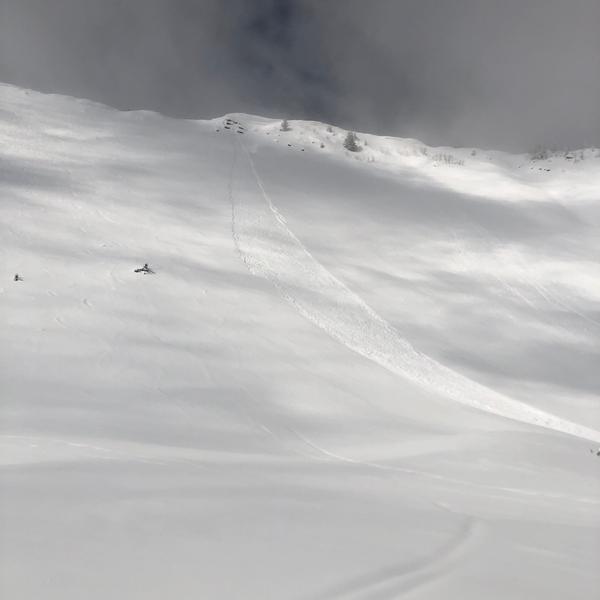
See picture of Natural Wet Loose that occurred around 1030 in West Monitor. This avalanche fanned out to at least 90 feet, and ran 650 vertical feet to the flats, while entraining and leaving 2 to 2.5 feet of debris.
Avalanche Problem #1
Problem
Wet Snow
Trend
Decreasing Danger
Problem #1 Comments
See above, and it was Likely that there were other Wet Loose Avalanches on the steep slopes that had aspects from East to South to West.
Avalanche Problem #2
Problem
Wind Drifted Snow
Trend
Decreasing Danger
Problem #2 Comments
Reports from American Fork Canyon indicated Natural Wind Slab Avalanches. As long as the winds remain Calm to Light the trend for this issue should decrease, and any old Wind Slabs may become more stubborn.
The Danger today was mostly Low except in areas adversely effected by warming and sun. Moderate appeared to be the Danger Rating in these steep specific locations.
For Wednesday, Low continues to cover most of the terrain, again with exceptions for any more Wet Loose and possible Wind Slabs if the winds do not follow the forecast predictions.
Today's Observed Danger Rating
Moderate
Tomorrows Estimated Danger Rating
Low
Coordinates