Sign Up for the Utah Snow and Avalanche Workshop (USAW) on December 7th!

Forecast for the Salt Lake Area Mountains

Trent Meisenheimer
Issued by Trent Meisenheimer on
Thursday morning, February 18, 2021
DANGEROUS AVALANCHE CONDITIONS EXIST AND TRAVELING IN AVALANCHE TERRAIN IS NOT RECOMMENDED.
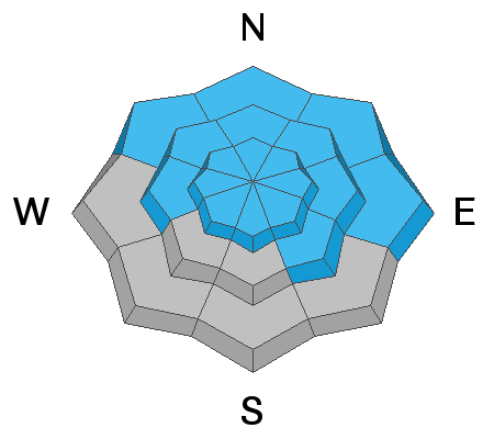
Today the avalanche danger is HIGH on all steep mid and upper elevation terrain. Avoid being under or near any steep slope. Even very small slopes can bury a person.
Heavy snowfall and a weak faceted snowpack have created very dangerous avalanche conditions. Natural and human-triggered avalanches are very likely.
Sunshine and powder will make us feel good today, and unfortunately, these are typically the days where we see avalanche fatalities. We've had six avalanche fatalities already in Utah. Please be careful and set a wide margin of safety today.
Low
Moderate
Considerable
High
Extreme
Learn how to read the forecast here
Special Avalanche Bulletin
Conditions are perfect for avalanche accidents. Heavy snowfall and drifting from strong winds have overloaded an exceptionally weak snowpack leading to extremely dangerous avalanche conditions.
All the fresh Utah powder will likely lure people into dangerous avalanche terrain, and people are likely to trigger deadly avalanches. A brief break in the weather will allow the avalanche danger to drop slightly; however, people can still trigger large and deadly avalanches if they venture onto steep slopes.
  • Avalanches triggered by people could be extremely large, very dangerous, unexpected, and deadly.
  • The Utah Avalanche Center recommends people avoid travel on or underneath slopes steeper than about 30 degrees in the backcountry for the next several days.
  • Even if you are experienced and have the proper avalanche safety equipment, you should still avoid all steep slopes in the backcountry.
Weather and Snow
Under patchy and partly cloudy skies, the last of the snow showers are rolling off the Great Salt Lake. In large, we are drying out today, and the weather will begin to clear out before the next storm moves in this evening. We should remain partly cloudy, with some low elevation clouds clinging to the mountains.
Current mountain temperatures at 700 MB (10,000') are -15 °C (5°F) and will be warming to -7.5 °C (18.5 °F) this afternoon. Winds will continue to be from the west-northwest and generally light throughout the day, with speeds in the 5-10 mph range gusting into the 20's at the upper elevations.
The past week has been a wet and wild ride here in Northern Utah; this prolonged storm cycle laid down some impressive snow totals around the state. Below are the rough storm totals from last Thursday to this morning.
Little Cottonwood: 60-82 inches of new snow with 4.0-6.73" water weight.
Big Cottonwood: 20-43 inches of new snow with 1.50-3.08" water weight.
PC Ridgeline: 20-30 inches of new snow with 1.5-2.0" water weight.
Ogden area: 20-30 inches of new snow with 1.5-2.5" water weight.
Provo area: 10-17 inches of new snow with 0.70-1.0" water weight.
Recent Avalanches
Starting yesterday morning around 5:00, am, the Wasatch Mountains started to come to life with a widespread historic natural avalanche cycle. Little Cottonwood Canyon was the center of attention for most of the day, with many large destructive avalanches. These avalanches were thousands of feet wide, connecting entire starting zones, breaking 6-10 deep, and running full track to the valley below. We are still trying to figure out the extent of the cycle, and hopefully, more information and pictures will come soon.
A couple more note-worthy avalanches came in from the Park City Ridge. Square Top and Wall of Voodoo avalanched roughly 1,000 feet wide 6-10 feet deep and ran full track. Another one from Sound of Music had roughly the same dimensions.
The last one to note was a low elevation avalanche from Happy Day's in Big Cottonwood. While this avalanche wasn't a valley crasher, it concerns me as this is the type of terrain many of us might visit today.
Ad
Avalanche Problem #1
Persistent Weak Layer
Type
Location
Likelihood
Size
Description
This storm has added a huge load of new snow (weight) to a very weak and faceted snowpack. Avalanches will remain big and destructive, 4-8 feet deep and hundreds of feet wide or larger.
The most suspect terrain continues to be the west through north through southeast, facing aspects at mid and upper elevations. HOWEVER, with so much snowfall - upper elevation south-facing terrain and low elevation north-facing terrain will also produce avalanches that break on buried persistent weak layers. Avoid being on or underneath any slope steeper than 30 degrees, as traveling in avalanche terrain is NOT recommended.
Keep in mind:
  • Avalanches can be triggered from a distance or below.
  • Avalanches are running downhill thousands of feet and crossing hiking trails and summer roads.
  • Any fresh wind slab or new snow avalanche may step down several feet into older snow.
  • Signs of instability, such as cracking or collapsing, might not be present today.
Avalanche Problem #2
New Snow
Type
Location
Likelihood
Size
Description
The recent storm snow will stabilize fairly rapidly, but today is not the day to push it. The new snow can easily avalanche 1-4 feet deep and several hundred feet wide. The bigger problem is that if you trigger any storm slab avalanche, it will likely step down into deeper weaker layers.
The wild card will be the sunshine today. Keep an eye out for the snow surface becoming warm and damp. If this happens and you start seeing roller balls in the steeper terrain, it's time to get out of there. I think this problem will be kept at bay with the cold upper elevation temperatures and patchy clouds. But, remember, we are in the mountains and conditions can change rapidly.
The good news: All of this storm snow is good for the snowpack. It will help heal our weak layers and will eventually stabilize in the coming weeks. However, in the short term, it's made our snowpack very unstable and dangerous. Be patient and give it some time to adjust.
General Announcements
Please visit this website with information about Responsible Winter Recreation by the Utah Office of Outdoor Recreation.

This information does not apply to developed ski areas or highways where avalanche control is normally done. This forecast is from the U.S.D.A. Forest Service, which is solely responsible for its content. This forecast describes general avalanche conditions and local variations always occur.