The
accident report for the tragic avalanche that killed four skiers in Millcreek Canyon on Saturday, Feb 6, is complete. All were well-known members of the backcountry community and all of us at the UAC are deeply affected. Our deep and sincere condolences go out to the family and friends so affected by this accident.
The Geyser Pass Road will be closed for plowing this morning. Expect the gate to be closed until around noon.
The Lower Utah Nordic Alliance (LUNA) plans to go up this afternoon to pack out trails and to start grooming.
24 Hour Snow 1" 72 Hour Snow 14" Base Depth in Gold Basin 50" Wind NW 0-5 Temp 16F
Light showers fell over the range yesterday with the east side picking up the most with reports of 2"-3". NW winds were light most of the day and are basically non-existent this morning. Look for winds to increase today as a storm system on northwest flow clips by bringing a chance for a few more inches of snow today. 1"-3" possible. NW winds will average 15-20 mph along ridge tops with gusts to 30. High temps at 10,000' will be in the upper teens. Unsettled weather under NW flow will continue through the week although Thu looks to be a pretty nice day. Long-range models don't currently have much excitement in store.
Snowpack Discussion
I don't expect the current snowfall to change the avalanche danger much but with increasing winds today, we may see some fresh drifts forming at upper elevations. On Saturday, almost 15" of new snow fell at more than 1.5" SWE (snow water equivalent) in a 12 hour period accompanied by 8-10 hours of moderate to strong SW winds. This was the greatest single loading event of the season, and with our pre-existing weak snowpack it gave me considerable cause for concern. On Sunday we had a good look around under sunny skies, and natural avalanche activity was surprisingly limited. Signs of instability were also quite muted although we did experience a collapse on a skin trail that had already seen at least a dozen skiers. I'm not entirely sure what to make of all this, but I do know that with our snowpack history and region-wide dangerous avalanche conditions, I'm going to have to allow more time for the snowpack to adjust, and gather more information before I'm willing to drop the current danger rating. And even then, I can't say that I'll be trusting steep terrain anytime soon, particularly slopes with a northerly aspect where deep and dangerous avalanches 2'-4' remain a constant threat.
Conditions report from Sunday, Feb 14:
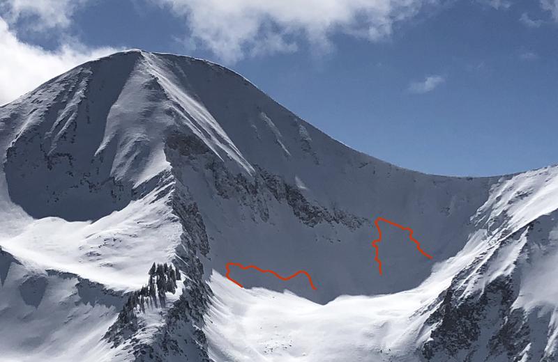
In our travels on Sunday, we observed these two natural avalanches from a distance beneath the N Face of Mount Tukuhnikivatz in Red Snow Cirque. Somewhat "pockety" in nature, they nevertheless had crowns up to 4' deep and could have easily buried or killed someone. Human-triggered avalanches such as this remain likely.
Charlie Ramser was up in Horse Creek yesterday where he reported seeing this
avalanche.


