March Kicks Off Our Spring Campaign- Donate Now to Support Forecasting

Forecast for the Uintas Area Mountains

Craig Gordon
Issued by Craig Gordon on
Sunday morning, January 31, 2021
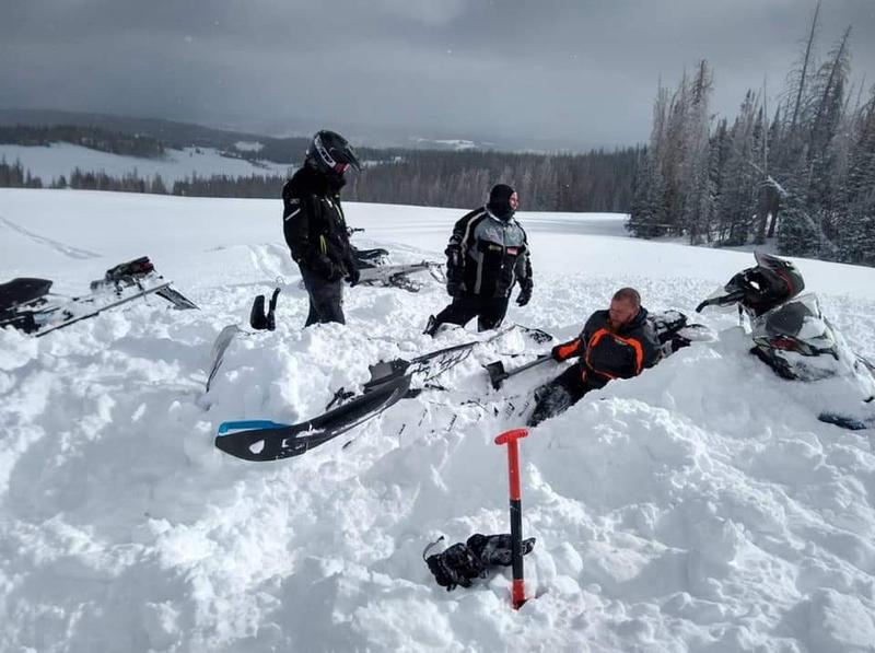
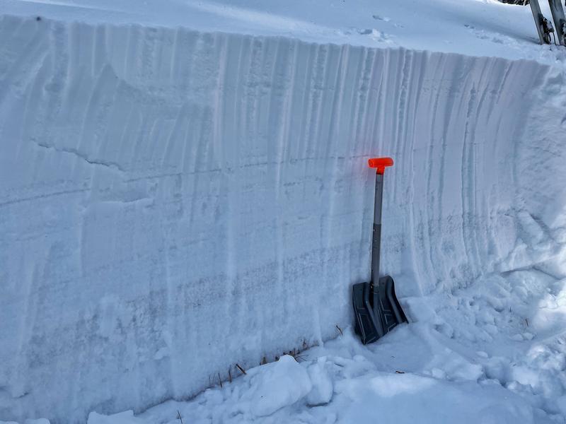
HEADS UP... dangerous avalanche conditions exist and human triggered avalanches are likely. Don't let fresh snow, sunshine and stoke cloud your decision making. Please think about your terrain choices and most important, think about getting home safely to your family at the end of the day
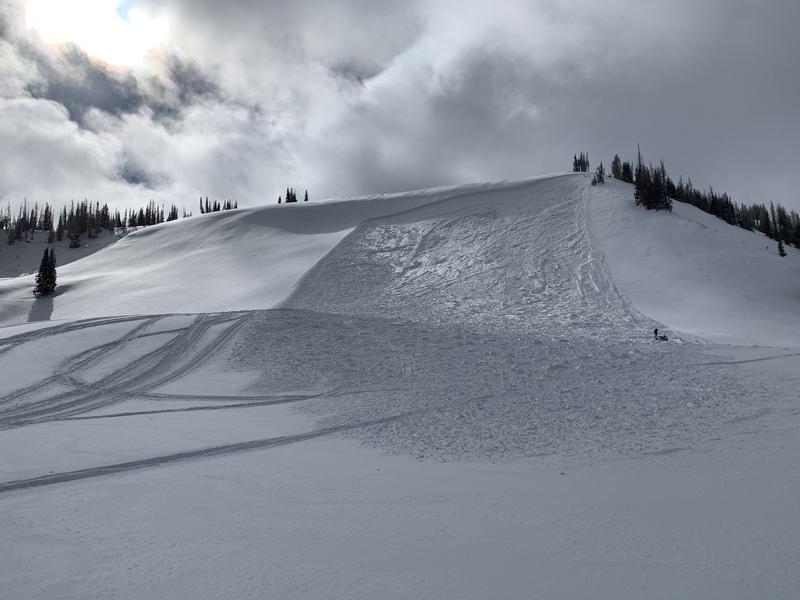
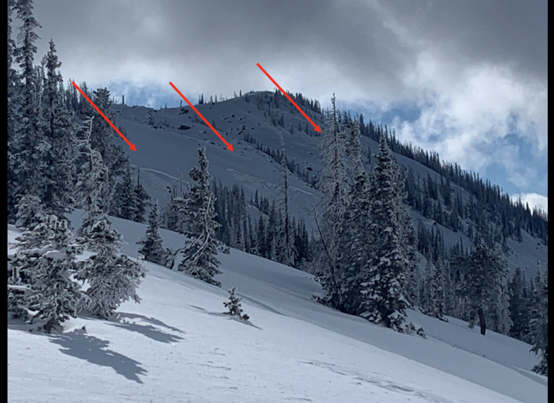
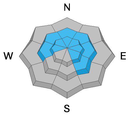
Near and above treeline today on slopes facing west through north through east, the avalanche danger is CONSIDERABLE and HUMAN TRIGGERED AVALANCHES ARE LIKELY. Today's avalanches are nothing to toy with as they are unmanageably large, breaking deep and wide, taking out the entire seasons snowpack.

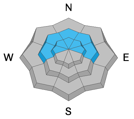
You'll find MODERATE avalanche danger at mid elevations and HUMAN TRIGGERED AVALANCHES ARE POSSIBLE on steep, wind drifted slopes, especially those facing the north half of the compass.

Here's your exit strategy- the Uinta's offer plenty of great, low angle terrain options. Simply stick with slopes less than 30 degrees in steepness and make sure there's no steep terrain above or adjacent to where you're riding. You can have a blast meadow skipping or carving deep trenches in wide open meadows... done and done.
Low
Moderate
Considerable
High
Extreme
Learn how to read the forecast here
Special Avalanche Bulletin
THE UTAH AVALANCHE CENTER HAS CONTINUED A SPECIAL AVALANCHE BULLETIN FROM 6 AM MST THIS MORNING TO 6 AM MST MONDAY.
FOR THE MOUNTAINS OF NORTHERN UTAH INCLUDING THE WASATCH RANGE, THE BEAR RIVER RANGE, AND THE UINTA MOUNTAINS.
CONDITIONS ARE PERFECT FOR AVALANCHE ACCIDENTS IN THE BACKCOUNTRY THIS WEEKEND. DANGEROUS AVALANCHE CONDITIONS EXIST. AVALANCHES COULD BE LARGE, VERY DANGEROUS, UNEXPECTED, AND PERHAPS DEADLY.
Special Announcements
It is with great sadness I report an avalanche accident which occurred late yesterday, along the Park City ridgeline, on Squaretop Peak. A preliminary report is found here.
Our collective thoughts, prayers, and energy go out to friends and family of all involved.
Weather and Snow
Nowcast-
Skies are clear and temperatures in the single digits and low teens. Winds are about as light as they get, blowing less than 10 mph even along the high peaks. This weeks storms were good to the eastern front, stacking up several feet of snow, dramatically improving riding and turning conditions.
Forecast-
Get out of the valley gunk and into the mountains where you'll find a stunning day with sunny skies, light winds, and high temperatures climbing into the mid 30's.
Futurecast-
Monday offers a mostly sunny day, but clouds stream into the region late in the day as another storm moves into the area. Computer models waffle somewhat on the strength and timing, but stay tuned, I'll have a better handle for tomorrows update.

Looking for real-time temps, snow, or wind?
Click here and then on the "western Uinta" tab for western Uinta specific, weather station network.
Recent Avalanches
It was a busy day with multiple avalanches and close calls reported. All the slides share the same characteristics with avalanches breaking deep and wide-
A close call on Yamaha Hill, but everyone comes home to their families. More info and insight found here
Meanwhile, pro observer Michael J triggered this large slide in Duke Bowl from a couple hundred feet away. Michaels thoughts are found here.

Click here to view recent trip reports and avalanche observations.
Ad
Avalanche Problem #1
Persistent Weak Layer
Type
Location
Likelihood
Size
Description
The snowpack is teetering on the edge and most slopes wait for a trigger like us to roll along and knock the legs out from underneath.
Here's the setup... multiple layers of weak, faceted snow (see photo below) lurk underneath the snow surface. And while the powder feels light and fluffy, we need to think not only about the snow we're riding in, but also the snow we're riding on. But let's not get caught up with technicalities. Look around... Mother Nature is screaming a warning to us with recent avalanches. Any slide triggered is gonna break deep and wide
Photo of a northeast facing slope near 10,000 feet. Riding conditions and coverage have improved greatly; however, you can still see the obvious layers of very weak snow.
In the video below, Andy describes the small avalanche they triggered and the snowpack layer that allowed them to trigger it.
Avalanche Problem #2
Wind Drifted Snow
Type
Location
Likelihood
Size
Description
Hurricane force, south and southeast winds ripped through the mountains midweek, forming dense cohesive slabs on leeward slopes at mid and upper elevations. Problem is... they're covered over with new snow making them hard to detect. The other problem, once triggered, they may break into deeper buried weak layers as the crash onto the slope below. Here's the good news... you can simply avoid this avalanche dragon by avoiding steep, wind drifted slopes, especially if the snow looks fat and rounded or feel and sounds hollow like a drum.
Additional Information
I will update this forecast by 7:00 AM tomorrow, Monday February 1st.
Your observations are import, so please let me know what you're seeing... click HERE and contribute to this amazing community based program
General Announcements
If you see or trigger an avalanche or just wanna let me know what you're seeing you can reach me directly at 801-231-2170 or [email protected]
This forecast is from the U.S.D.A. Forest Service, which is solely responsible for its content. This forecast describes general avalanche conditions and local variations always occur.