Join us at our 2nd Annual Blizzard Ball

Forecast for the Moab Area Mountains

Eric Trenbeath
Issued by Eric Trenbeath on
Monday morning, January 25, 2021
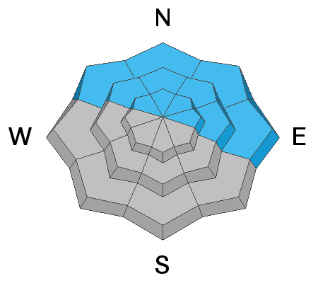
New and wind drifted snow have added stress to underlying persistent weak layers and the avalanche danger is CONSIDERABLE on steep slopes that face NW-N-E. Human triggered avalanches are likely in these areas and these slopes should be avoided for the foreseeable future. In addition, there is a MODERATE danger for human triggered avalanches involving new snow on all aspects. A ride in an avalanche with the current low snow conditions will be rugged. Temper your enthusiasm for the new snow, and keep your slope angles low.
Low
Moderate
Considerable
High
Extreme
Learn how to read the forecast here
Special Announcements
Check out the most recent blog post from Chris Benson with a recap of the current state of the snowpack and an analysis of the sometimes thin line between Moderate and Considerable danger.
The Geyser Pass Road will be covered with several inches of fresh snow this morning.
Cross Country Ski Trails are covered in several inches of fresh snow. The Lower Utah Nordic Alliance (LUNA) can be followed on Instagram @luna_moab.
Weather and Snow
24 Hour Snow 9" 72 Hour Snow 15" Base Depth in Gold Basin 36" Wind S 5-15 Temp 12F
Slow and steady, the snow is beginning to stack up! Overnight WNW winds were mostly light before shifting back to the SW where they should remain mostly light today. Look for lingering showers this morning and mostly cloudy skies before the next system moves into the area this evening. This storm seems to be taking a slightly more southerly track but I thought that before. Right now it looks like we'll see about 3"-5". Brief ridging will occur on Wednesday before moving on Thursday, followed by the next Pacific low that will start moving into the region on Friday. Wax your boards and tune up your machines, it may finally be game on in the La Sals!
Wind, temperature, humidity on Pre Laurel Peak (11,700')
Snotel site near Geyser Pass Trailhead (9600')
Storm totals at the Gold Basin study plot (10,000')
Snowpack Discussion
Snow is piling up and adding additional stress to our weak and faceted snowpack and it isn't rocket science to know that this will produce dangerous avalanche conditions. In my travels to the Abajos Saturday, I found very sensitive conditions with widespread shooting cracks and collapsing on any slope that had pre-existing faceted snow. Reed Kennard and Ed Grote were up on Laurel Ridge yesterday, and although things aren't quite as sensitive here, they too reported signs of instability, and upside-down snowpack, and red flag weather conditions. Read their report here.
The following video illustrates the red flag signs of instability I observed in the Abajos on Saturday. La Sal conditions aren't quite as sensitive but they aren't far behind.
Ad
Avalanche Problem #1
Persistent Weak Layer
Type
Location
Likelihood
Size
Description
The accumulated snow load of the past few days has added stress to buried persistent weak layers of loose, sugary faceted snow. Saturday's dense snow, accompanied by wind, created a slab over top of this weak snow. This slab is ripe for human triggers on steep slopes facing NW-N-E, which is basically, any steep slope that has enough snow to ski or ride. This problem will only get worse as additional snow piles on top and it will continue to be a danger for the foreseeable future. As new snow makes more terrain accessible, temper your enthusiasm and avoid north-facing slopes steeper than 30 degrees as well as connected, lower angle terrain.
Avalanche Problem #2
New Snow
Type
Location
Likelihood
Size
Description
Human triggered, loose snow sluffs, or soft slab avalanches within the recent snow will be possible on steep slopes on all aspects today. Look for signs of instability such as cracking in the snow surface. On northerly facing slopes, any avalanche triggered within the new snow will almost certainly involve buried persistent weak layers causing a deeper and much more dangerous avalanche. Steep, northerly facing slopes should be avoided.
General Announcements
This forecast is from the U.S. Forest Service, which is solely responsible for its content. This forecast describes general avalanche conditions and local variations always occur.