Observation: Knob Mountain

Observation Date
12/29/2020
Observer Name
John Pikus
Region
Skyline » Cedar Creek » Knob Mountain
Location Name or Route
Knob Mountain
Weather
Sky
Clear
Wind Direction
Northwest
Wind Speed
Calm
Weather Comments
Beautiful day to be in the mountains. Skies were clear until around 1:30 when low, scattered clouds started moving across the mountains. Winds were calm in the morning and began picking up along ridgelines in the afternoon. Felt cold in the shade and reasonably warm in the sun due to the lack of wind.
Snow Characteristics
New Snow Depth
8"
New Snow Density
Low
Snow Surface Conditions
Powder
Snow Characteristics Comments
Snow depths in the Cedar Creek area ranged from about 4 inches at the mouth of the canyon to 8 inches at 10,000 feet. New snow was right-side up and low density. On Northerly aspects the snow fell on settled powder whereas the snow fell on a solar crust on west and south aspects.
Red Flags
Red Flags
Cracking
Collapsing
Poor Snowpack Structure
Red Flags Comments
Red flags are not quite as constant/in your face as they were a week and a half ago but they are still there. I experienced intermittent cracking and several collapses, including a particularly thunderous one while crossing a NW facing meadow at 9,700 feet. The weak layer is easily found by either pushing the end of a ski pole through the snowpack or simply stepping out of your skis (or off your snow machine) and rapidly sinking to the ground.
Avalanche Problem #1
Problem
Persistent Weak Layer
Trend
Same
Problem #1 Comments
On North aspects at mid and high elevations there is up to a foot of weak faceted snow at the base. There is now a growing slab on top of this weak layer. From looking around it looks like we have not had enough of a load to create natural avalanches in most places but I would expect steep north facing slopes to avalanche if we get either a larger storm or if humans travel onto them.
Comments
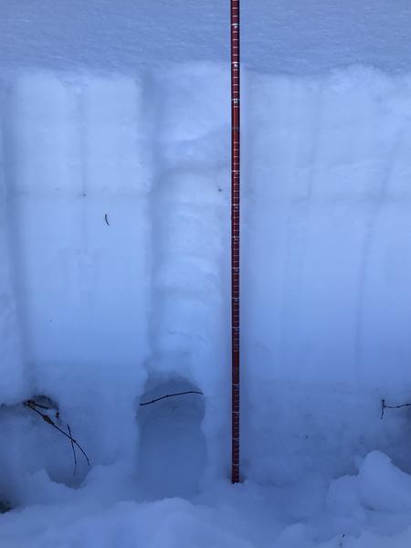
Today's tour was on Knob Mountain at elevations ranging from 7,000 to 10,100 feet on primarily north and west-facing aspects. The snowpack is slowly growing and making travel in the mountains easier but we could still use quite a bit more snow to cover logs and deadfall, especially at the mid elevations. I dug a pit on a Northwest facing slope at 9,650 feet (see attached photo.) Total snow depth here was 85 cm. There is a 30 cm layer of very weak faceted snow at the bottom of the snowpack, with a 55 cm slab of right-side up snow above it. The top 20 cm of this is the new low-density snow from last nights storm which isn't too cohesive yet. This was in a very sheltered area, and I might expect to find denser and more cohesive slabs in areas with more wind-affected snow or at higher elevations where it has snowed more. As explained above, the main avalanche problem to watch out for is slab avalanches failing on the persistent weak layer of facets at the ground.
Today's Observed Danger Rating
Considerable
Tomorrows Estimated Danger Rating
Considerable
Coordinates