Forecast for the Uintas Area Mountains

Craig Gordon
Issued by Craig Gordon on
Sunday morning, December 27, 2020
In the wind zone, at and above treeline, CONSIDERABLE avalanche danger exists. Human triggered avalanches are LIKELY on steep, wind drifted slopes. Steep terrain facing the north half of the compass, and particularly slopes with an easterly component to its aspect are most suspect.
Mid elevations offer MODERATE avalanche danger on steep slopes facing the north half of the compass and human triggered avalanches are POSSIBLE.
In either case, shallow snow cover and low tide conditions barely hide natural obstacles like stumps and rocks, so, triggering even a small slide can lead to an instant buzz-kill and a season ending injury.
LOW avalanche danger is found on mid and low elevation slopes, particularly those facing south, but snow cover is super thin.
Low
Moderate
Considerable
High
Extreme
Learn how to read the forecast here
Special Announcements
Thanks for sharing your snow, your slope, and your stoke... well played!
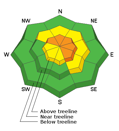
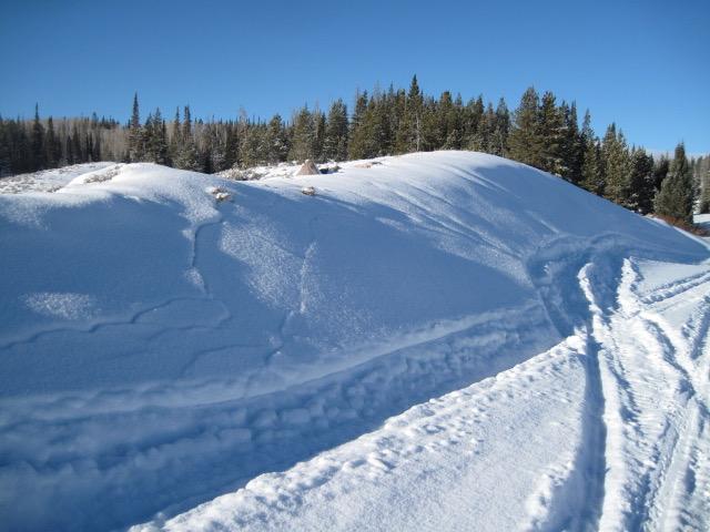
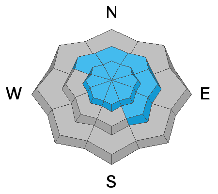
A big shout out, high fives, and air hugs to the crew I met on Christmas Eve at Wolf Creek who not only brought an amazingly positive energy to the day.... you showed how to avoid avalanche danger by choosing the right terrain. In the image above, everyone opted to avoid the avalanche dragon on the steep, shady slope yet still had a great day on low angle terrain facing the south half of the compass, riding shallow pow, with their families, in the sun.
You know the program... roadside attractions are still an easy grab and just 'cause you can see it from the car doesn't mean it's safe or you're good to go. And remember, our front-line health care workers are maxed out. So, let's collectively think about our decisions and the consequences that may have on others.
Thanks to the generous support of our local resorts, Ski Utah, and Backcountry, discount lift tickets are now available. Support the UAC while you ski at the resorts this season. Tickets are available here.
Weather and Snow
Nowcast-
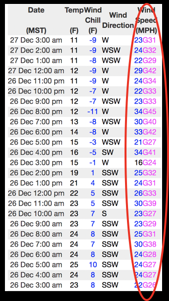
I thought it was going to be a bust, but yesterday's storm materialized nicely for the eastern front, delivering 6" of medium density snow overnight. Temperatures are in the low to mid teens. West and southwest winds are a bit obnoxious, blowing 20-30 mph along the high ridges. A little fresh snow is gonna go a long way, but total snow depths still average just about two feet in depth, so the Uinta's are still quite thin and travel is sorta limited to road rides and grassy slopes.
Forecast-
Look for mostly cloudy skies and a few lingering flurries as last nights system slides to the east. High temperatures climb into the mid 20's. Westerly winds decrease as the day wares on.
Futurecast-
Snow ramps up overnight into Monday and winds shift to the east and then eventually northwest, as colder air filters into the region. Not a big, game changing storm, but at least respectable with totals in the 6" range by Tuesday morning. Another storm is slated for mid week.
Looking for real-time temps, snow, or wind?
Click here and then on the "western Uinta" tab for western Uinta specific, weather station network.
Recent Avalanches
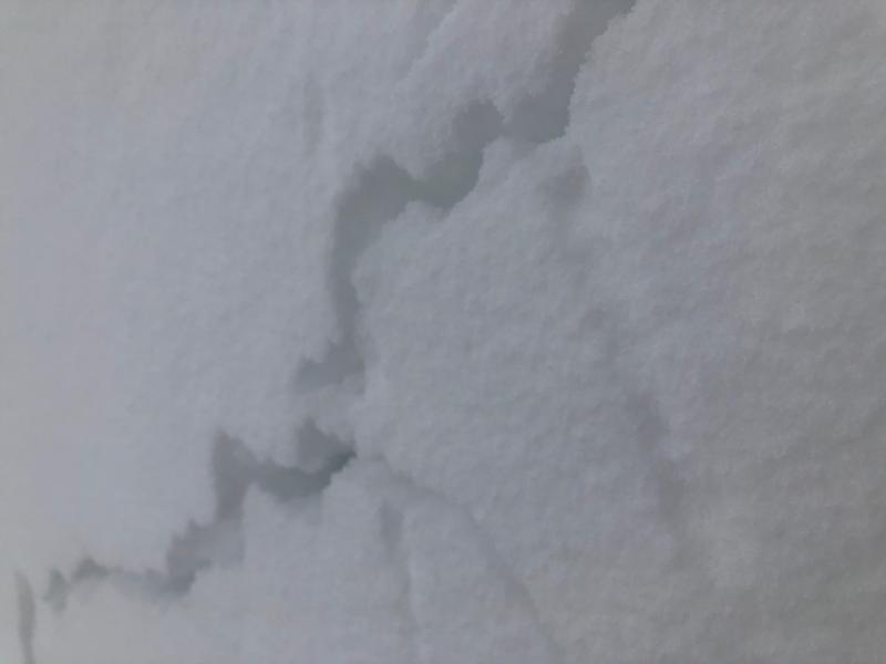
Lots of collapses and shooting cracks yesterday, but no significant new avalanche activity to report.
To view trip reports and recent avalanche activity, simply click here.
Ad
Avalanche Problem #1
Persistent Weak Layer
Type
Location
Likelihood
Size
Description
Chad Brackelsberg, Executive Director for the UAC, stomped around Mt. Watson yesterday and posted the great viddy above, which illustrates our current setup. His entire trip report is found here.
Persistent weak layers... they're are a pain in the pack because they linger for long periods of time. And recent history tells us that every time we stack up additional snow or windload to our fragile snowpack, we see human triggered avalanches. Problem is... nothing's changed with this problem child because we're not getting plastered with big storms, or the dense, heavy snow needed to help add a thick, insulating coat to our snowpack. As a matter of fact, we're getting nickeled and dimed with just enough snow to keep the weak layers teetering on the edge. So here's the setup. The snowpack foundation mirrors an upside-down cake... think, stronger snow on weaker snow. This type of layering leads to tricky avalanche conditions because there's not widespread, in-your-face, natural avalanche activity. Rather, our snowpack needs a trigger like us to roll along and knock the legs out from underneath. And yes... we can trigger slides from a distance or from adjacent slopes, and this is the type of avalanche dragon where we can pull the entire log pile down on top of us, even if we're playing on low angle terrain. All we need is to be connected to steep terrain above us. And once triggered, today's avalanches may break wider and deeper than you might expect.
But you don't have to ride blind... so, tweak small test slopes like the one in the image above, looking for and listening to signs of unstable snow like whoomping sounds and sudden collapses of the snowpack or shooting cracks in front of your skis, board, or sled. And of course the biggest clue of all... recent avalanches, especially on the same types of slopes you wanna ride on.
Avalanche Problem #2
Wind Drifted Snow
Type
Location
Likelihood
Size
Description
Above is a 24 hour data grab from Windy Peak. Not crazy, raging winds, but the kind of consistent wind loading needed to form an evenly distributed and more connected slab.
With some fresh storm snow for winds to work with, I bet today's drifts are gonna be more widespread and more reactive to our additional weight. Found mostly on the leeward side of upper elevation ridges, 24 hours of consistent winds, drifted snow lower downslope than you might expect, and cross-loaded terrain like chutes and gullies. In either case, it's an easy and mostly manageable avalanche problem to avoid by simply steering clear of any fat, rounded piece of snow, particularly if it sounds hollow like a drum. And remember... our snowpack is super shallow and triggering even a small slide can take you for a body-bruising ride through rocks and stumps barely hidden under the thin snowpack.
Additional Information
Last Friday I rolled up to a fresh avalanche and found Utah Snowmobile Association president, Cal Taylor, investigating the slide and performing a mock rescue with his riding partner Mike Davis. In the video above, Cal has some sage advice for our riding community.
I'll update this forecast by 7:00 AM tomorrow, Monday December 28th.
Your observations are import, so please let me know what you're seeing... click HERE and contribute to this amazing community based program
General Announcements
If you see or trigger an avalanche or just wanna let me know what you're seeing you can reach me directly at 801-231-2170 or [email protected]
The information in this forecast is from the US Forest Service which is solely responsible for its content.