Forecast for the Moab Area Mountains

Eric Trenbeath
Issued by Eric Trenbeath on
Wednesday morning, December 23, 2020
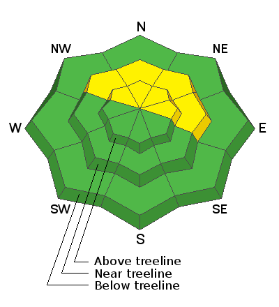
A MODERATE avalanche danger exists on steep northerly facing slopes where isolated wind drifts or shallow soft slabs are overlying layers of weak, sugary, faceted snow. Overall low coverage makes it very difficult to access avalanche terrain at this time, but if you find yourself in these areas, suspect slopes that have smooth, rounded deposits of wind drifted snow. or that feel hollow underneath. Cracking, whumphing, or collapsing of the snowpack are signs of instability. Even a small avalanche triggered under these conditions can have serious and painful consequences.
Low
Moderate
Considerable
High
Extreme
Learn how to read the forecast here
Special Announcements
The Geyser Pass Road above the winter trailhead has officially closed to wheeled vehicles for the season. This closure is in effect from Dec 15 - May 15. The road to the trailhead is snowpacked and slick. 4wd is recommended.
The Lower Utah Nordic Alliance (LUNA) last groomed trails on Sunday.
Please visit this website with information about Responsible Winter Recreation by the Utah Office of Outdoor Recreation.
We've kicked off Season 4 of the UAC podcast with a Conversation with American Avalanche Institute owner Sarah Carpenter. You can stream it HERE or wherever you get your favorite podcasts.
Weather and Snow
24 Hour Snow 2" 72 Hour Snow 2" Base Depth in Gold Basin 20" Wind NW 10-15 Temp 2F
Storm totals at the Gold Basin Study Plot (10,000')
Wind, temperature, humidity on Pre Laurel Peak (11,700')
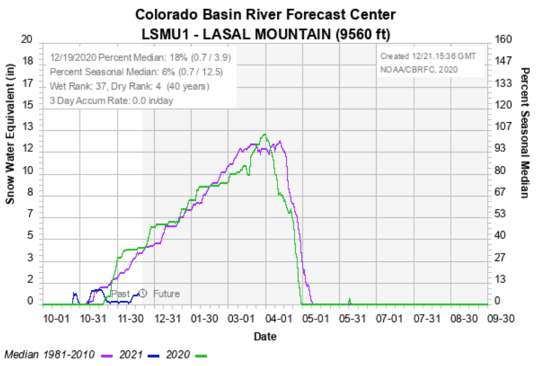
Snotel site near Geyser Pass Trailhead (9600').
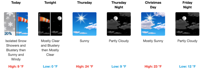
NWS weather forecast
Snowpack Discussion
Overall coverage is still too thin for skiing and riding off of packed roads. Snow depths range from about 6" near the Geyser Pass Trailhead with up to 2' at upper elevations. The current snowpack structure is very poor. In some areas, a shallow, soft slab has developed on top of the weak snow, and signs of instability such as collapsing and whumphing are being experienced. This setup does not bode well for any future snowload.
Recent Avalanches
Dustin Randall from ROAM Industry down in Monticello sent in this photo of a remotely triggered avalanche on a steep, northerly facing slope near 11,000' in the Abajos. This is exactly the type of setup we are concerned with right now. In spite of the low snow conditions, the existing, underlying snow is very weak, and anywhere that a slab exists on top, is primed and ready for an avalanche.
Ad
Avalanche Problem #1
Persistent Weak Layer
Type
Location
Likelihood
Size
Description
On mid and upper elevation northerly aspects, the snowpack has deteriorated into layers of weak, sugary, faceted snow on top of a slick, hard bed surface. In exposed areas, stiff wind drifts exist on top of this weak snow, while in other areas, a shallow, soft slab has formed. Avoid steep terrain that has a smooth, rounded appearance, or that feels hollow underneath. Cracking, whumphing, or collapsing of the snowpack are signs of instability.
Additional Information
I don't need to tell everyone things aren't looking good but in case you want to know how bad it is, we are currently at 17% of normal snowpack.
General Announcements
This forecast is from the U.S. Forest Service, which is solely responsible for its content. This forecast describes general avalanche conditions and local variations always occur.