Join us at our 2nd Annual Blizzard Ball

Forecast for the Salt Lake Area Mountains

Trent Meisenheimer
Issued by Trent Meisenheimer on
Wednesday morning, December 23, 2020
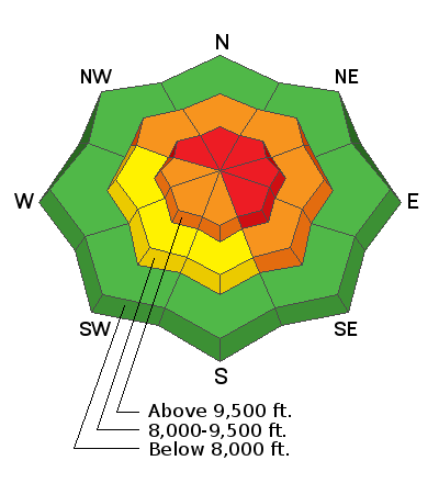
HIGH avalanche danger exists on steep slopes facing northwest through southeast above about 9,500' for triggering a slab avalanche 1-3' deep, and traveling in avalanche terrain is NOT recommended.
There is a CONSIDERABLE avalanche danger on steep slopes between 8,000'-9,500' that face northwest through southeast; and on steep slopes facing south, southwest, and west at upper elevations, for triggering slab avalanches 1-3' deep. Careful snowpack evaluation, cautious route-finding, and conservative decision-making will be essential. Avalanches can be triggered from a distance.
Below 8,000', there is a LOW avalanche danger simply because there isn't enough snow.
Low
Moderate
Considerable
High
Extreme
Learn how to read the forecast here
Special Announcements
Thanks to the generous support of our local resorts, Ski Utah, and Backcountry, discount lift tickets are now available.
Support the UAC while you ski at the resorts this season. Tickets are available here.
Weather and Snow
Yesterday's cold front dropped 2-4" of new snow during frontal passage accompanied by lighting and thundersnow. Northerly winds blew hard for most of the day from the west-northwest at speeds of 25-35 mph with gusts into the 60's and 70's. Overnight, we picked up another 6" of snow in favored areas on a northwest flow bringing snow totals to 7-11" of new snow with 0.40-0.70" of water at the upper elevations.
Currently, in the wake of a strong cold front, the northerly wind continues to blow at speeds of 20-30 mph, gusting into the 50's at the highest elevations. Mid elevation winds are more reasonable with speeds in the 10-15 mph range. Mountain temperatures are in single digits, with a wind chill below zero °F. Winds are supposed to calm down later this morning.
Recent Avalanches
We've had many avalanches reported to the UAC over the past week, and you can find all avalanches and observations HERE. Yesterday, we had one avalanche reported from Grizzly Gulch that was on a steep northerly slope that sheds its snow into a terrain trap. This is a concerning slide to me as it could be the start of another string of remotely/rider triggered avalanches today.
During the peak winds and snow, I would imagine some slopes went through a natural avalanche cycle at some point yesterday or overnight.
Ad
Avalanche Problem #1
Persistent Weak Layer
Type
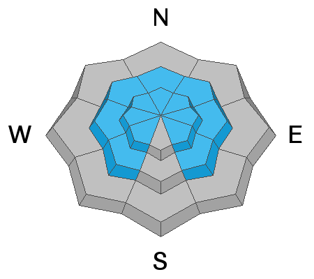
Location
Likelihood
Size
Description
Each storm continues to add weight to our fragile snowpack. This weight can be added from snow falling from the sky or the wind blowing the snow from one location to another. In any case, it just doesn't take much to stress the weak, faceted, old snow below.
It's a simple set up - we have a weak layer and a slab. There are two other critical components to triggering an avalanche; we need a slope steep enough to slide (generally greater than 30° in steepness). We need a trigger (skiers and riders make good triggers). These four components of a slab avalanche are good to know because if we remove any one of the components we don't get an avalanche. Unfortunately, we can't remove the slab and weak layer.
However, I can choose to ride slopes less than 30° in steepness with nothing steep above or adjacent to me and not trigger avalanches. For now, that's the only option we have, especially if we want to avoid being caught in an avalanche. Persistent Weak Layer avalanches are responsible for nearly 70% of all avalanche fatalities here in Utah.
Video: Field day in American Fork
Avalanche Problem #2
Wind Drifted Snow
Type
Location
Likelihood
Size
Description
West and northwest winds have been blowing 20-30 mph for nearly the past 24 hrs. With roughly 10" of new snow to blow around, I would expect a fresh batch of drifts scattered throughout the range. Some slopes will have hard drifts, and others will be soft. As always, look for and avoid any fresh deposits of wind-blown snow. Cracking and collapsing within the new snow is a sign of instability.
Adding wind drifted snow to any slope with weak faceted snow beneath will only make the avalanche deeper, wider, and more dangerous.
General Announcements
Please visit this website with information about Responsible Winter Recreation by the Utah Office of Outdoor Recreation.

This information does not apply to developed ski areas or highways where avalanche control is normally done. This forecast is from the U.S.D.A. Forest Service, which is solely responsible for its content. This forecast describes general avalanche conditions and local variations always occur.