Forecast for the Uintas Area Mountains

Craig Gordon
Issued by Craig Gordon on
Wednesday morning, December 23, 2020
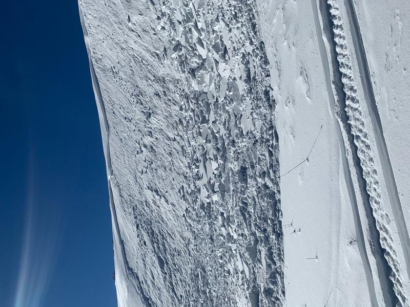
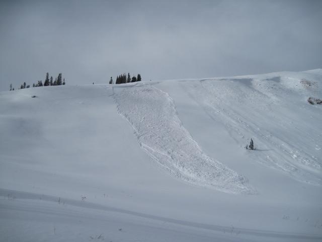
Expect dangerous avalanche conditions at upper elevations. Once triggered, todays avalanches will break deeper and wider than you might expect.
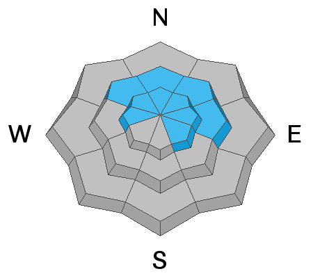
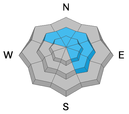
In the wind zone, at and above treeline, CONSIDERABLE avalanche danger exists. Human triggered avalanches are LIKELY on steep, wind drifted slopes. Terrain facing the north half of the compass, and particularly slopes with an easterly component to its aspect should be avoided.
Mid elevations offer MODERATE avalanche danger on steep slopes facing the north half of the compass and human triggered avalanches are POSSIBLE.
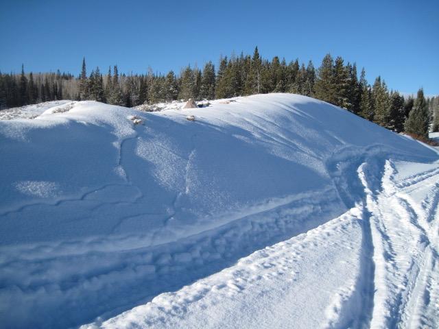
In either case, shallow snow cover and low tide conditions barely hide natural obstacles like stumps and rocks, so, triggering even a small slide can lead to an instant buzz-kill and a season ending injury.
LOW avalanche danger is found on mid and low elevation slopes, particularly those facing south, but snow cover is super thin.
Low
Moderate
Considerable
High
Extreme
Learn how to read the forecast here
Special Announcements
Thanks to the generous support of our local resorts, Ski Utah, and Backcountry, discount lift tickets are now available. Support the UAC while you ski at the resorts this season. Tickets are available here.
Weather and Snow
Nowcast-
As yesterday's storm winds down, light snow showers continue, adding a few ultra-light flakes to Wednesday's evenly distributed 7" storm total. West and southwest winds finally relaxed right around midnight, switched to the northwest and currently blow 10-20 mph along the high ridges. With current temperatures registering near zero, you'll find a toe-numbing -20 degree wind chill... ouch. And while yesterday's storm is a welcome sight, total snow depths throughout the range average just about two feet in depth, so the Uinta's are still quite thin and travel is sorta limited to road rides and grassy slopes.
Forecast-
Skies clear and northwest winds begin relaxing later today. It'll be cold with highs barely cracking into the teens and with clear skies in the queue, overnight lows crater into negative territory.
Futurecast-
High pressure builds through Christmas with a slow warming trend. A quick hitting storm is slated for Saturday with another stronger looking system slated for early next week.
Looking for real-time temps, snow, or wind?
Click here and then on the "western Uinta" tab for western Uinta specific, weather station network.
Recent Avalanches
Triggered over the weekend on a steep, wind drifted, upper elevation, northeast facing slope, this slide broke to weak snow in the mid portion of the snowpack... this is exactly the type of avalanche dragon we're dealing with again today.
No significant new avalanche activity to report from yesterday.
To view trip reports and recent avalanche activity, simply click here.
Ad
Avalanche Problem #1
Persistent Weak Layer
Type
Location
Likelihood
Size
Description
Nothing has changed with our problem child... a persistent weak layer of snow, now buried in the mid portion of our snowpack. And while yesterday's storm wasn't a dense, heavy, knock the entire house of cards over kind-of-snow, recent history tells us that every time we stack up additional snow or windload to our fragile snowpack, we see avalanches. So here's the setup. The current snowpack structure mirrors an upside-down cake... think, stronger snow on weaker snow. This type of layering leads to tricky avalanche conditions because there's not widespread, in-your-face, natural avalanche activity. Rather, our snowpack needs a trigger like us to roll along and knock the legs out from underneath. And yes... we can trigger slides from a distance or from adjacent slopes, and this is the type of avalanche dragon where we can pull the entire log pile down on top of us, even if we're playing on low angle terrain. All we need is to be connected to steep terrain above us. And once triggered, today's avalanches may break wider and deeper than you might expect.
But you don't have to ride blind... so, tweak small test slopes like the one in the image above, looking for and listening to signs of unstable snow like whoomping sounds and sudden collapses of the snowpack or shooting cracks in front of your skis, board, or sled. And of course the biggest clue of all... recent avalanches, especially on the same types of slopes you wanna ride on.
Avalanche Problem #2
Wind Drifted Snow
Type
Location
Likelihood
Size
Description
Above is a great illustration of one of our avalanche problems today. Our main man with the Uinta plan, Ted Scroggin, stomped around the Double Hill zone last Saturday, catching this fresh wind slab peeling off the ridge, which in turn, triggered a deeper slide as it crashed on the slope below.
Winds cranked all day Wednesday and they had no problem creating yet another round of fresh drifts, reactive to our additional weight. And now, those drifts are camouflaged by a layer of light density snow, making them hard to detect. Found mostly on the leeward side of upper elevation ridges, you'll also want to be on the lookout for drifts forming lower downslope than you might expect, as well as cross-loaded terrain like chutes and gullies. In either case, it's an easy and mostly manageable avalanche problem to avoid by simply steering clear of any fat, rounded piece of snow, particularly if it sounds hollow like a drum. And remember... our snowpack is super shallow and triggering even a small slide can take you for a body-bruising ride through rocks and stumps barely hidden under the thin snowpack.
Additional Information
You know the program... roadside attractions are still an easy grab and just 'cause you can see it from the car doesn't mean it's safe or you're good to go. And remember, our front-line health care workers are maxed out. So, let's collectively think about our decisions and the consequences that may have on others.
Last Friday I rolled up to a fresh avalanche and found Utah Snowmobile Association president, Cal Taylor, investigating the slide and performing a mock rescue with his riding partner Mike Davis. In the video above, Cal has some sage advice for our riding community.
I'll update this forecast by 7:00 AM tomorrow, Thursday December 24th.
Your observations are import, so please let me know what you're seeing... click HERE and contribute to this amazing community based program
General Announcements
If you see or trigger an avalanche or just wanna let me know what you're seeing you can reach me directly at 801-231-2170 or [email protected]
The information in this forecast is from the US Forest Service which is solely responsible for its content.