Join us at our 2nd Annual Blizzard Ball

Forecast for the Salt Lake Area Mountains

Drew Hardesty
Issued by Drew Hardesty on
Tuesday morning, December 22, 2020
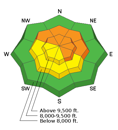
A CONSIDERABLE avalanche danger exists on many slopes at the mid and upper elevations. Human triggered avalanches 1-2' deep remain likely...and may still be triggered from a distance.
The danger for new snow and wind slabs will also be on the rise today. Know that any new snow avalanche in steep shady terrain may step down and trigger a much deeper avalanche.
Conservative decision making and awareness of changing conditions will be essential today.
Low
Moderate
Considerable
High
Extreme
Learn how to read the forecast here
Special Announcements
Thanks to the generous support of our local resorts, Ski Utah, and Backcountry, discount lift tickets are now available.
Support the UAC while you ski at the resorts this season. Tickets are available here.
Weather and Snow
Skin wax on Solstice.
Saturn and Jupiter kiss.
Strange year gets stranger.
The Situation:
Skies are clear...but not for long.
A sharp and quick hitting cold front will arrive before noon and snowfall will continue into the night. The NWS has issued a Winter Weather Advisory and - if everything aligns right - we may see 6-10" (or more) in areas favored by a northwest flow. Southwesterly winds picked up in the early morning hours with hourly averages of 30-35mph. Gusts at 11,000' have reached 80mph. Current mountain temps are in the upper 20s up high, the upper 30s down low. The highest elevations may flirt with 0°F by late tonight. Unfortunately it does look as if the northwest winds will remain gusty well after frontal passage today.
We'll need this snow - Sunday's rain/rime event along with wind, sun and terribly warm temperatures have taken their toll on the snow conditions.
The Outlook:
We should see clearing skies tomorrow through Friday. We'll see gradually warming temperatures through the end of the week with a storm slated for Saturday that should bring another round of snow.
Recent Avalanches
Two more reports of avalanches trickled in from the backcountry yesterday. And I am shaking my head as I type this - some reports of some shallow wet sluffs and rollerballs on the shortest day of year.
  • Walking the ridgeline above Alexander Basin, a skier remotely triggered a smaller pocket in steep terrain on a northeast facing slope at roughly 9800'. This presumably stepped into the NFL (Nov Facet Layer).
  • Larry Dunn and his partners glassed across the drainage what looked to be a skier triggered pocket in steep west facing terrain near the Tri-Chutes (elev. 10k) in upper White Pine of LCC. The pocket appears to be about a foot deep and 40' wide.
Beyond the activity, cracking and collapsing remain the rule and not the exception.

You can find all of these reports in the Observations and Avalanches tab in the Menu above or by clicking HERE.
Uncertain of locations? You can select "Map view" on the Observations/Avalanches page or look things up on the Wasatch Backcountry Skiing guide. Or map. Or better yet, download the app,
Ad
Avalanche Problem #1
Persistent Weak Layer
Type
Location
Likelihood
Size
Description
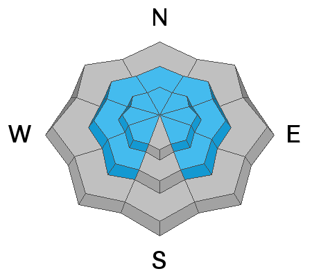
These avalanches are what we call 'Unmanageable' - that is, they are predictable in their unpredictability: they may be triggered at a distance or from below. Here's a good example yesterday from avalanche pro Bill Nalli - While conducting a snow test in safe but representative terrain in the Brighton backcountry, "propagation happened after 14 taps. After spending 15-20 minutes in the snow pit, while putting my skis back on to fill in the hole, the entire slope collapsed up to 30' around where I was standing."
Continue to give yourself plenty of margin. Travel advice would be to stick to low angle terrain until the snowpack has adjusted.
The snowpack has a hard time adjusting with every event that adds additional stress - like this morning's strong southwesterly winds and today/tonight's additional snowfall.
Avalanche Problem #2
Wind Drifted Snow
Type
Location
Likelihood
Size
Description
Although Sunday's rime event and yesterday's sun and warming may have limited the overall snow available for transport, there is some...and there will likely be more drifting during and after the midday cold front. Look for and avoid any fresh deposits of wind blown snow. Owing to previous and expected moderate to strong winds, drifts may be found on a variety of aspects although they'll be more pronounced along the higher elevations. I've known winds to strip away a capping rime crust and blow the exposed dry snow into shallow slabs.
Avalanche Problem #3
New Snow
Type
Location
Likelihood
Size
Description
By the afternoon, you may be able to trigger shallow new snow avalanches in the steepest terrain. The new snow is likely to bond fairly well with many of the warm, corrugated crusts on the east to south to west aspects and bond less favorably on the northerly aspects. Note that new snow avalanches are particularly sensitive when snowfall rates are the highest....and aspect doesn't matter.
Additional Information
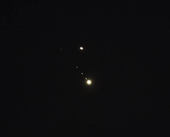
Many years ago, one of the Little Cottonwood Canyon snow rangers, Peter Lev, attempted to find a correlation between the moon's gravitational pull with avalanche activity. His "tidal charts" are still used today by some avalanche operations. He recently told me that the original idea came from his co-worker Binx Sandahl. I wonder what their opinions would be of the Jupiter and Saturn overlap in the early evening Solstice sky? (photo of the planets and the moons of Jupiter sent by one of Lev's old colleagues). The last time the planets appeared this close and could be seen from the ground was in 1226.
General Announcements
Please visit this website with information about Responsible Winter Recreation by the Utah Office of Outdoor Recreation.

This information does not apply to developed ski areas or highways where avalanche control is normally done. This forecast is from the U.S.D.A. Forest Service, which is solely responsible for its content. This forecast describes general avalanche conditions and local variations always occur.