

Observation Date
12/20/2020
Observer Name
Derek DeBruin
Region
Ogden » Ben Lomond » Cutler Ridge
Location Name or Route
Cutler Ridge
Comments
First tour on Cutler Ridge for me this season (been biding my time to get a sufficient amount of snow), so we did a lot of poking and digging to attempt to get a synoptic idea of conditions. There was lots of ski stomping, ski pole probing, hand shears, etc. as well as about a half dozen pits across aspects and elevations. Specific pits and pertinent results are noted below. Otherwise, this is my big picture summary for the zone.
At lower elevations (<7000ft), once off the cross-country groomer and on the skin track, we found snow depths of 50-70cm, with about 15 to 20cm new snow on top. Below this is a thin crust, about 5cm of facets, 10cm of more stout, supportable crust, and finally about 30cm of facets to the ground. We did not find any collapsing or cracking, nor much for consolidated slab in the surface snow. However, the snow structure is poor and hand shears failed with moderate resistance on the crust/facet interface. Given how much of the north half of the compass at low elevations was still harboring the old November snow before the most recent series of snow events, I'll be wary and assessing carefully in NW-N-E terrain even at the low elevations. Zones such as the Birthday Bowls and the Backyard come to mind as potential concerns.
The crust begins to disappear in the mid elevation band (7000-8500ft). The crust is spotty based on aspect starting around 7600ft but appears to be gone completely by about 8200ft. Between 7600 and 8200ft, the crust seems to be present only on the west aspects, give or take 45 degrees on the compass in either direction. In the same zone, east facing slopes harbor crust-facet sandwiches lower down (such as Indicator Hill at 7200ft), though the crust disappears higher (gone by 8000ft, perhaps lower). Interestingly, east aspects throughout these elevations have a layer of basal ice on the ground, around 5cm thick, with a narrow strip of small grain facets atop the ice. The northern quadrant of the compass is most concerning. Snow depths are 60-90cm, with facets composing the bottom 40-45cm of the snowpack. On a northwest slope around 7900ft I found ECTP7 Q2 failing at or just above the facet/new snow interface. The adjacent slope collapsed under the load of a skier (noted above). We found similar snowpack structure up to 8500ft.
We just broached the upper elevations below the saddle as digging a pit in wind affected snow while getting blasted with 30+mph wind and snow didn't seem like it would add too much to the data. I dug below the saddle a bit below 8600ft on a NNE aspect in 100cm of snow. There was 45cm of 4F snow atop 55cm of facets to the ground. I found ECTP12 Q1, a high energy "pop and drop," catching the offending block of snow on my thighs. While the dense powder below looked appealing, it didn't seem like a good idea to tickle the dragon.
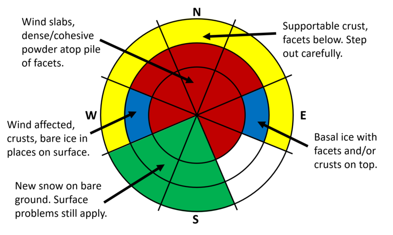
Since I'm a visual learner, I've uploaded a graphical compass rose of my understanding of the snowpack and terrain right now.
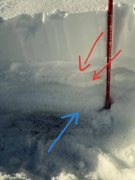
Pit from Indicator Hill showing surface snow (15cm), two crusts (red arrows) with facets between and below, and finally 5cm of ice (blue arrow) on the ground.
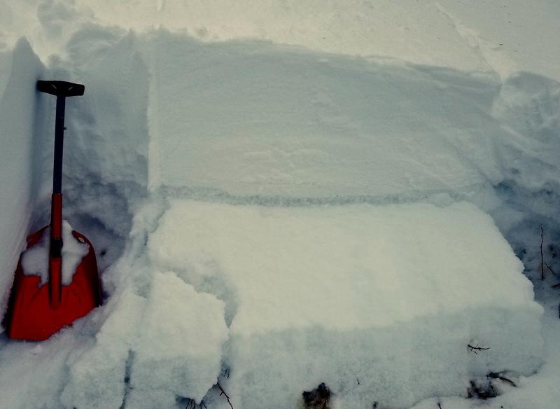
Pit around 8600ft NNE slope, ECTP12 Q1. Wish I'd gotten video. Hopefully this image of where the block used to be before it energetically fell out will do instead.
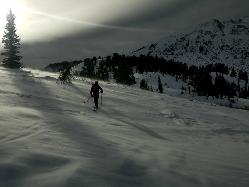
Ca. 8000ft, blowing snow on the surface (most visible in upper left of photo near the conifer), wind affected surface (mottled), and patches of bare ice (the smooth parts).
Today's Observed Danger Rating
Considerable
Tomorrows Estimated Danger Rating
Considerable