Observation: Twin Lakes Pass

Observation Date
12/17/2020
Observer Name
Greg Gagne
Region
Salt Lake » Little Cottonwood Canyon » Grizzly Gulch » Twin Lakes Pass
Location Name or Route
Grizzly Gulch / Twin Lakes Pass
Weather
Sky
Obscured
Precipitation
Light Snowfall
Wind Direction
Southwest
Wind Speed
Moderate
Weather Comments
Winds were sustained moderate, with occasional strong gusts. Looking at weather station at top of Collins lift, gusts were in the low 40's mph.
Snow Characteristics
New Snow Depth
2"
New Snow Density
Medium
Snow Surface Conditions
Powder
Wind Crust
Snow Characteristics Comments
Periods of S1 snowfall. SW winds were swirling from all directions, with prominent drifting on north and east aspects.
Cracking in wind-drifted terrain. Some minor collapsing.
Red Flags
Red Flags
Recent Avalanches
Heavy Snowfall
Wind Loading
Cracking
Collapsing
Poor Snowpack Structure
Red Flags Comments
Snowfall rates were generally light (< 1 cm/hr) while I was out, but they are forecasted to increase later this afternoon, with 6/7 red flags.
Avalanche Problem #1
Problem
Persistent Weak Layer
Trend
Increasing Danger
Problem #1 Comments
Moderate to strong winds with upwards of 1" of water weight over a short period of time may be enough to get widespread avalanching on the persistent weak layer that is currently down about 30 cms. All the signs are in place: cracking, collapsing, remotely-triggered avalanches, very poor snow stability test scores.
Avalanche Problem #2
Problem
New Snow
Trend
Increasing Danger
Problem #2 Comments
With about 30 cms of snow containing an inch of water expected over a 12-hour period, the storm snow is likely to be sensitive well into Friday. Am less concerned about storm snow instabilities with such a prominent persistent weak layer problem: it is the storm snow (and wind drifting) that will overload the buried faceted layer.
Comments
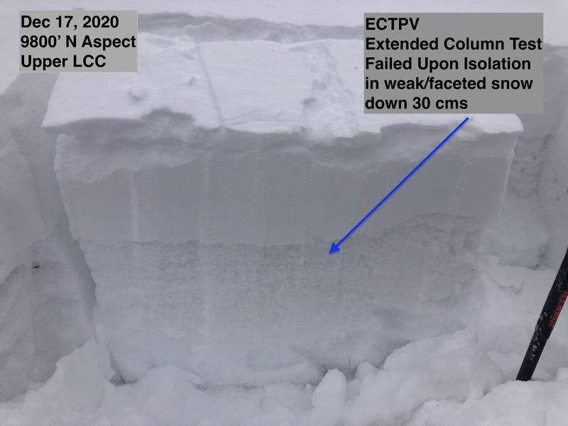
Photo and video below show extended column test that failed upon isolation (this is scored ECTPV), failing in the faceted layer currently down 30 cms. We are expected to double the size of the slab on top of the facets in a 12-16 hour period. This rapid loading of this weak layer should result in HIGH avalanche danger beginning Friday.
One thing I want to share is that I dug several pits today, and some did not propagate across the column, with only a fracture of the vertical block. However, rather than seeing the few of those pits as a sign of stability, I instead focused on the ECTPV and handful of ECTP < 10 as signs of instability. In other words, I pay attention to test results that demonstrate instability, rather than those that demonstrate stability.
Video
Today's Observed Danger Rating
Considerable
Tomorrows Estimated Danger Rating
High