Forecast for the Uintas Area Mountains

Craig Gordon
Issued by Craig Gordon on
Tuesday morning, December 15, 2020
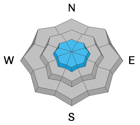
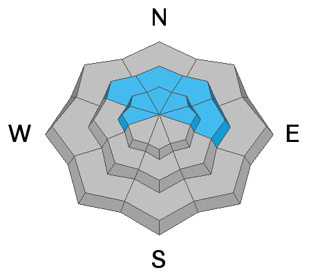
In the wind zone, at and above treeline, you'll find MODERATE avalanche danger on steep, wind drifted slopes. Human triggered avalanches are POSSIBLE, especially on slopes facing the north half of the compass. It'll be touchy today and once triggered, avalanches may break deeper and wider than you might expect.
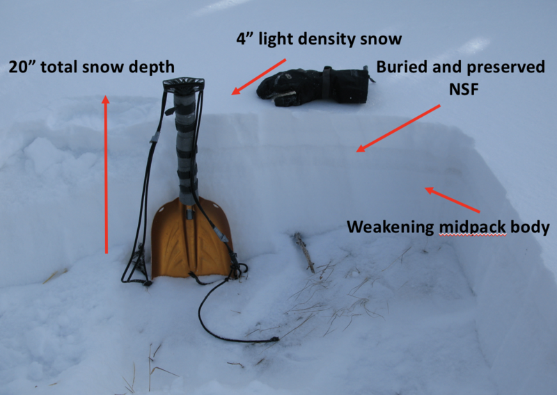
Remember- shallow snow cover and low tide conditions barely hide natural obstacles like stumps and rocks. Triggering even a small slide can lead to an instant buzz-kill and a season ending injury.
Low
Moderate
Considerable
High
Extreme
Learn how to read the forecast here
Special Announcements
Roadside attractions are still an easy grab and just 'cause you can see it from the car doesn't mean it's safe or you're good to go. Our front-line health care workers are maxed out. So, let's collectively think about our decisions and the consequences that may have on others.
Looking for ways to navigate through an unusual winter? Please visit this website with information about Responsible Winter Recreation by the Utah Office of Outdoor Recreation
Weather and Snow
Nowcast-
High clouds drape the mountains and light snow continues falling as yesterday's storm exits the region, leaving nearly 6" of very light density snow in its wake. Temperatures cratered overnight, currently registering in the single digits. North and northeast winds blow 15-20 mph along the high ridges and that makes for a crisp morning with windchill values clocking in at -17 degrees. Riding and turning conditions are slowly improving, though total snow depths throughout the range average just 12"-18", so the Uinta's are still quite thin and travel is sorta limited to road rides and grassy slopes.
Forecast-
Light snow showers wind down, clouds thin out as the day wares on, and temperatures remain on the cold side with highs barely creeping into the low teens. Northerly winds increase late in the day, becoming strong by days end, blowing in the 40's and 50's along the high peaks.
Futurecast-
A break in the action slated for Wednesday with the next storm system on track to bring a good shot of denser snow beginning Thursday and persisting into Friday morning.
Looking for real-time temps, snow, or wind?
Click here and then on the "western Uinta" tab for western Uinta specific, weather station network.
Recent Avalanches
Visibility was a bit limited yesterday and no new avalanche activity to document, though reports from the backcountry indicate a snowpack coming to life with cracking and collapsing a common theme.
To view trip reports and recent avalanche activity, simply click here.
Ad
Avalanche Problem #1
Wind Drifted Snow
Type
Location
Likelihood
Size
Description
A bump in winds overnight created a fresh round of drifts that'll react to our additional weight. Found mostly on the leeward side of upper elevation ridges, you'll also want to be on the lookout for cross-loaded terrain like chutes and gullies. In either case, it's an easy and mostly manageable avalanche problem to avoid by simply steering clear of any fat, rounded piece of snow, particularly if it sounds hollow like a drum. And remember... our snowpack is super shallow and triggering even a small slide can take you for a body-bruising ride through rocks and stumps barely hidden under the thin snowpack.
Avalanche Problem #2
Persistent Weak Layer
Type
Location
Likelihood
Size
Description
The image above reflects a simple snow profile from the south half of the range this weekend.
Last weeks high and dry weather created a layer of weak surface snow or what we call near surface facets. In the short term it's loud, recrystallized powder and good riding. In the long term it turns into a headache, especially once its buried, because it becomes the next problem child in the snowpack. And that's exactly our setup right now as last weekend's storm snow buried and preserved this weakness. This becomes a potentially problematic scenario, especially as we add additional weight to our developing snowpack. Think about an upside-down cake... or stronger snow on weaker snow. This type of layering leads to tricky avalanche conditions, where we can trigger slides from a distance or from adjacent slopes. And once triggered, today's avalanches may break wider and deeper than you might expect.
But you don't have to ride blind... so, look for signs of unstable snow like loud whoomping sounds and sudden collapses of the snowpack or shooting cracks in front of your skis, board, or sled.
Additional Information
Last week we installed a snow study site near Camp Steiner and it's up and running! Click HERE real-time snow fall, total snow depth, and current temperatures. This data fills in a big black hole of snow information near Mirror Lake. I'd like to give a big shout out to Sean and Jesse from the NWS along with Ted Scroggin, our main man in the Uinta's... the entire crew is featured in the viddy above.
I'll update this forecast by 7:00 AM tomorrow, Wednesday December 16th.
Your observations are import, so please let me know what you're seeing... click HERE and contribute to this amazing community based program
Information on outdoor recreation - The State of Utah created this webpage with information about recreating on both state and federal public lands during the current health crisis.

Skiing and riding at closed ski resorts - Some resorts allow access now, and some do not. Please check HERE for the latest info on ski area access.

New to the backcountry (including riding at closed resorts) - Watch the award-winning, 15 minute Know Before You Go video, or take the 5-part, free online-learning series.
General Announcements
If you see or trigger an avalanche or just wanna let me know what you're seeing you can reach me directly at 801-231-2170 or [email protected]
The information in this forecast is from the US Forest Service which is solely responsible for its content.