Join us at our 2nd Annual Blizzard Ball

Forecast for the Salt Lake Area Mountains

Mark Staples
Issued by Mark Staples on
Sunday morning, December 13, 2020
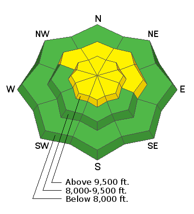
Today the avalanche danger at upper elevations will be MODERATE where winds have deposited snow. Look for and avoid these freshly formed slabs of wind drifted snow which will be small but easy to trigger.

The danger is also MODERATE at all upper elevation slopes and at mid elevations on NW, N, NE, & E facing slopes where you can trigger an avalanche in the new snow on non wind loaded slopes. The new snow should produce loose snow avalanches and possibly some soft slab avalanches where the new snow rests on old, weak, faceted snow.
The avalanche danger is LOW at low elevations and at mid elevations on west and south facing slopes.

HEADS UP: There is a significant danger of hitting rocks, stumps, and other obstacles. These hazards will be hard to see, but they will be easy to hit because they are covered by yesterday's low density snow. Go slow and be careful. There are many reasons to avoid getting hurt and further stressing emergency services and the health care system
Low
Moderate
Considerable
High
Extreme
Learn how to read the forecast here
Weather and Snow
Yesterday: The upper Cottonwood Canyons received 12-15 inches of very low density snow (~5%). Lower parts of the canyons and the Park City Ridgeline received 5-8 inches of snow. Snowfall ended at about 5 p.m. Winds increased last night at upper elevation ridgelines and blew 10-20 mph from the north with gusts up to 35 mph.
This morning: Temperatures dropped into the single digits F in most places while some trailhead locations have temperatures a few degrees below zero F. Winds became more westerly and eased to 5-10 mph.
Today: Temperatures will warm into the low to mid 20s F in most places. Skies will be partly cloudy this morning with more clouds arriving later today as the next storm approaches. Winds should increase around midday and blow about 20 mph from the west and southwest.
Snowfall should return around midnight and continue through most of Monday. Because it will remain cold and should snow most of day on Monday, snow amounts could end up being about of foot of low density snow. Tuesday and Wednesday should be mostly dry followed by more snow on Thursday.
Recent Avalanches
Yesterday, ski areas were able to trigger some shallow soft slabs of new snow. In the backcountry there was some cracking observed and some easy sluffing of the new snow. Read all the observations HERE.
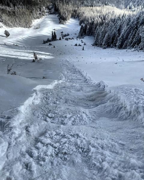
The photo below shows a long-running sluff along the Park City ridgeline that involved the new snow sliding on weak faceted snow underneath. (photo - M. White)

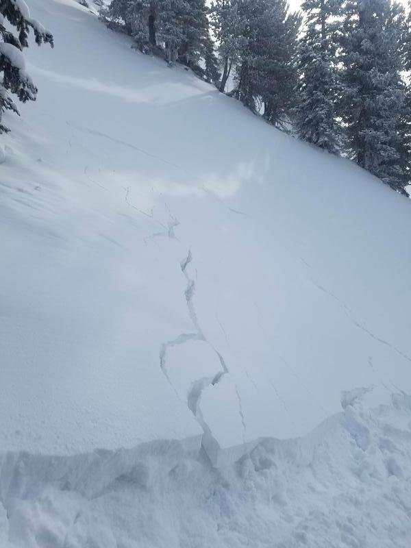
Despite being so low density, the new snow did produce some cracking as one person found in Silver Fork (photo - C. Jensen).
Ad
Avalanche Problem #1
Wind Drifted Snow
Type
Location
Likelihood
Size
Description
Yesterday Greg said it best "the snow was so light that you could sneeze and easily move it". Last night, north winds increased and readily transported the new snow at upper elevations. Over the last 48 hours, winds have blown from the north, west, and southwest. Later today they will increase from the southwest again.
What this all means is that soft slabs of wind drifted snow can be found under ridgelines and along cross-loaded gullies on many different aspects. These wind slabs are most likely resting on weak, faceted, old snow that will make them easy to trigger today.
The good news is that winds have mainly been confined to upper elevation ridgelines, and you can find many slopes without wind drifted snow.
Avalanche Problem #2
New Snow
Type
Location
Likelihood
Size
Description
Our dilemma is that we want to ride slopes that had plenty of snow on them prior to yesterday's storm, but these slopes are exactly the ones where the old snow became weak and faceted and the new snow hasn't bonded to it.
For this reason, the new snow should easily sluff and produce small loose snow avalanches as in the video below. What I'm uncertain about is whether or not the new snow has bonded to itself and will act as a cohesive slab. With such cold temperatures, I doubt this has happened overnight but it may happen today as temps warm into the 20s F today. The new snow should talk to you and show obvious signs of instability like collapsing, whumpfing, and shooting cracks. If you see these signs, the new snow has become cohesive and will produce a slab avalanche.
Video of loose snow avalanche yesterday on the Park City ridgeline (M. White)
Additional Information
Weeks of dry weather and clear, cold skies have weakened and faceted the snowpack on nearly all slopes at mid and upper elevations. The only exceptions are slopes facing due south that received direct sunshine. Even the slightest aspect change away from due south means that the snowpack is very faceted. South facing slopes with the slightest bit of shade from trees or other terrain features will have faceted snow as well.
What does this mean? Slab avalanches require 4 ingredients - slab, weak layer, steep slope, and a trigger. The old snow is the weak layer. Snow falling in coming weeks will become the slab. We are the trigger. There is no doubt that avalanches will start happening as more snow comes. The main strategy to avoid avalanches will be to avoid riding on slopes steeper than 30 degrees.
Watch the video below to learn more.
General Announcements
Please visit this website with information about Responsible Winter Recreation by the Utah Office of Outdoor Recreation.

This information does not apply to developed ski areas or highways where avalanche control is normally done. This forecast is from the U.S.D.A. Forest Service, which is solely responsible for its content. This forecast describes general avalanche conditions and local variations always occur.