Observation Date
12/12/2020
Observer Name
Greg Gagne
Region
Salt Lake » Park City Ridgeline
Location Name or Route
Park City Ridgeline via Guardsman
Comments
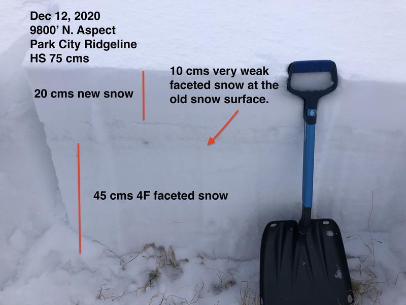
Even though we only had < 0.5" of water weight from the Friday/Saturday storms, the weak snow at the old snow surface was very reactive to stability tests with very easy shears. The new snow is not yet acting as a cohesive slab, so it is currently only sluffing on steeper slopes. But once the slab begins to sinter (become cohesive) or we add some wind-blown snow or additional storm snow, widespread avalanching on this layer will become more pronounced.
The existing snow prior to the Friday/Saturday storms was quite weak, but there was a fair amount of variability in the structure. In some thinner snowpack areas it was weak and unsupportable, but in some areas where the snowpack was deeper (and probably wind-drifted from strong wind events in mid-November) it is supportable with 4F hardness. Despite the variability, what I am finding in common is that the old snow surface was very weak and this will likely be the initial weak layer as we add more of a load to the snowpack this coming week.
Photo below highlights an area with a generally stronger snowpack (45 cms of 4F+ denser snow at the base), but the darker stripe just above this is the weak, faceted snow surface that was buried underneath Friday/Saturday storm snow.
Low danger at low and mid elevations, Moderate at upper elevations where there are pockets of fresh drifts or greater snow amounts (pushing 30 cms) where the sluffs can entrain more snow.

Today's Observed Danger Rating
Moderate
Tomorrows Estimated Danger Rating
Moderate
Coordinates


