

Observation Date
12/10/2020
Observer Name
Derek DeBruin
Region
Ogden » Ogden Mountains
Location Name or Route
Ogden Mountains
Comments
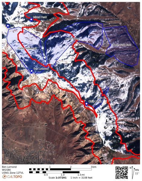
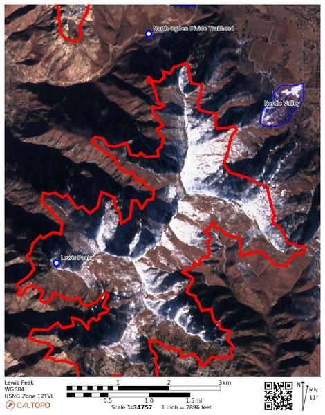
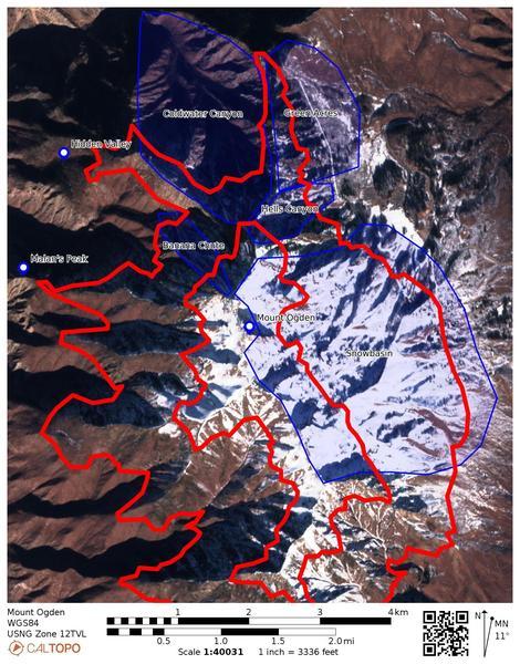
Trying a new visualization for current snow on the ground (hopefully!) in advance of the coming new snow. My few wanderings have revealed similar findings to those of others, a mix of crusts and facets; in other words, NOT a good thing for subsequent snow to be resting on. Consequently, any snow presently on the ground is suspect for future avalanches. Each of these pics is satellite imagery from a couple days ago (2020/12/08). Based on what I can see from my house, this isn't significantly different than what's still on the ground today. The red lines are approximate contour lines for 8500ft and 7000ft, which differentiate Ogden's upper, mid, and low elevation bands. The outside edge of each image is the low elevation band, the inner part of each image is the upper elevations, with mid between the red lines. Indicated in blue are some well known landmarks, zones, etc. to help identify the features in the satellite imagery. I'll emphasize again that contour lines and map locations are approximate. The entire Ogden skyline is posted here from north to south: Ben Lomond, Lewis Peak, and Mount Ogden (images include names of the massif in the lower left corner).
Ben Lomond: Things on the west side of the skyline crest have a solid chance at new snow falling on bare ground in the mid and lower elevations. The upper elevations are holding snow at all aspects with the exception of due south. However, threading the needle of due south while avoiding southwest and southeast would be a very challenging proposition indeed, given how much snow still remains on those aspects at the upper elevations. The east side of the crest is holding plenty of snow, with slopes still harboring the frozen stuff even at low elevations. I'll be treating all of Cutler Ridge with respect and keeping my slope angles low (<30 degrees).
Lewis Peak: Lewis Peak doesn't actually reach into the upper elevation band, so the contour line in the image is at 7000ft (the demarcation between low and mid). However, the long north-south ridge on Lewis Peak catches plenty of wind, so for wind problems, the ridgeline can behave like the upper elevation band. In the low elevation band there really isn't much for snow, save for just a bit in the north facing terrain near the Divide and Nordic Valley. The middle elevation band (where the skiing is!) is pretty dry on southwest, south, and southeast aspects, and mostly dry on west aspects. I'll be wary of anything northwest to north to east.
Mount Ogden: It's a similar story on the Mount Ogden massif, though there are some cold and shady recesses leaving snow on the ground even into the low elevation band in places. The high elevation is pretty well coated with the exception of due south and perhaps southwest. In the mid elevations, there's still plenty of snow on the north half of the compass, including east aspects and even a bit of west here and there. In the low elevations, Coldwater still has a bit of snow, and there's a surprising amount in the Green Acres zone, too. Taylor's Canyon also has snow in most of the skiable terrain. This would be a good time to avoid the Banana Chute and Hell's Canyon, probably for months.
Today's Observed Danger Rating
None
Tomorrows Estimated Danger Rating
None