Join us at our 2nd Annual Blizzard Ball

Forecast for the Salt Lake Area Mountains

Trent Meisenheimer
Issued by Trent Meisenheimer on
Thursday morning, December 10, 2020
Today, the overall avalanche danger is LOW on all aspects and elevations. This means that human-triggered avalanches are unlikely, but small avalanches in isolated areas are possible.
Low
Moderate
Considerable
High
Extreme
Learn how to read the forecast here
Special Announcements
This week is the 2nd Annual Avalanche Awareness Week. We will be hosting avalanche awareness and education events across the state of Utah. Get a full schedule of events here.

The holiday season is right around the corner!! Looking for that special something for your partner? or yourself?
Well, we've got an easy shopping solution for you...Buy your gifts at our Pray for Snow online auction.
Weather and Snow
Under mostly cloudy skies, the mountain temperatures are about ten degrees cooler than they were 24hrs hours ago, with all-mountain weather stations below freezing. Winds are currently from the west blowing 15-20 mph at the upper elevations while the mid and lower elevation anemometers are spinning 5-10 mph. For today, we can expect increasing cloud cover as a weak storm moves into Northern Utah this evening. This storm is weak and may bring a few snow showers overnight without much accumulation expected.
The best chance for snow will be late Friday into Saturday as a much better storm moves into Utah with the chance of 4-8" of new snow. This storm lingers into Sunday, with another storm on Monday into Tuesday. Next week looks to be active with accumulating snow. FINALLY!
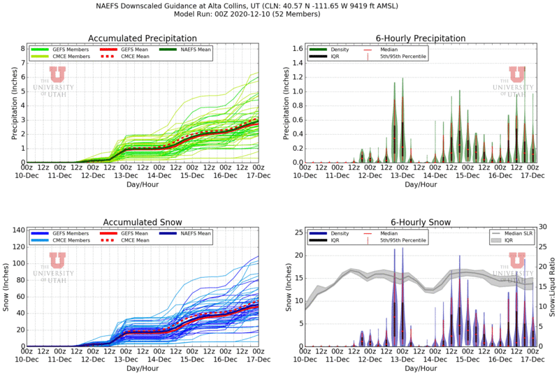
Jim Steenburgh is an Atmospheric Sciences Professor at the University of Utah and has a great weather page found HERE. One of the more popular products is the Plumes for snow and water amounts at Alta Collins, as seen below.
Recent Avalanches
No new avalanches were reported from the backcountry.
Please keep the excellent observations coming - they help us map the locations of the weak faceted snow. This will be critical ahead of the next winter storms. You can find all observations HERE
Ad
Avalanche Problem #1
Normal Caution
Type
Location
Likelihood
Size
Description
With strong winds and heavy snowfall in the forecast, backcountry avalanche conditions will change drastically. If you plan to head into the backcountry this weekend, keep a few things in mind:
  • Carry an avalanche transceiver, probe, shovel, and have a partner.
  • Remember, we have weak (faceted) snow on many aspects and elevations. This weak snow will produce avalanches (on slopes greater than 30°) once we load it with new snow.
  • Persistent weak layer avalanches are responsible for nearly 70% of all avalanche fatalities.
  • Stick to low angle terrain (riding slopes less than 30° in steepness), and avoid being on, under, or adjacent to steep slopes.
  • Be patient and let the snowpack adjust to the new load, it's a long season, and this new snow will be great for our mountain snowpack in the long run.
  • It's likely our snowpack will remain dangerous through Christmas.
Additional Information
On Tuesday, I spent my field day mapping faceted snow (weak layers) on many different aspects and elevations. Basically, to sum it all up; WE HAVE WEAK FACETED SNOW on all aspects at the mid and upper elevations. Now, due south-facing slopes are lacking faceted snow for the most part. However, if you turn just slightly east or west, the snowpack becomes faceted. If you find a shade line or a shaded pocket on a south-facing slope, it's faceted and weak.
This means; once we bury the current snow surface, it will be tough to tell what southerly terrain had bare dirt vs. slopes with a patchy snowpack. Usually, southerly facing terrain is not an issue with this type of weak layer. However, this setup is tricky because the only aspect that doesn't have a weak layer is very narrow, and the slightest mistake in aspect would likely lead to an avalanche.
My strategy will be riding slopes less than 30° in steepness once we get a storm on top of this weak snow... There is no doubt we will have an avalanche cycle once we load this weak faceted snow with stronger heavy snow on top.
General Announcements
Please visit this website with information about Responsible Winter Recreation by the Utah Office of Outdoor Recreation.

This information does not apply to developed ski areas or highways where avalanche control is normally done. This forecast is from the U.S.D.A. Forest Service, which is solely responsible for its content. This forecast describes general avalanche conditions and local variations always occur.