March Kicks Off Our Spring Campaign- Donate Now to Support Forecasting

Forecast for the Uintas Area Mountains

Craig Gordon
Issued by Craig Gordon on
Wednesday morning, December 2, 2020
The avalanche danger is generally LOW. The biggest threat is slamming into a season ending obstacle like a tree stump, barely hidden under the surface of our early season snowpack.
Low
Moderate
Considerable
High
Extreme
Learn how to read the forecast here
Special Announcements
Just 'cause you can see it from the car doesn't mean it's safe or you're good to go. Our front-line health care workers are maxed out. So, let's collectively think about our decisions and the consequences that may have on others, especially if we need outside assistance or a rescue.
The holiday season is right around the corner!! Looking for that special something for your partner? or yourself?
Well, we've got an easy shopping solution for you. Buy your gifts at our Pray for Snow online auction.
If you missed the 13th Annual Utah Snow and Avalanche Workshop, the recordings are available for purchase from the UAC Store. Click here for more details.
Looking for ways to navigate through an unusual winter? Please visit this website with information about Responsible Winter Recreation by the Utah Office of Outdoor Recreation
Weather and Snow
Nowcast-
Under clear skies, temperatures are in the single digits and northeast winds blow 15-25 mph along the high ridges. Throw in a bit of windchill and temperatures register right around -15 degrees.... ouch. If you blinked, you probably missed Monday nights little storm that added a mighty inch or two to our vertically challenged snowpack.
Forecast-
Look for sunny skies with high temperatures climbing into the teens and mid 20's. The bigger news are the winds. A dry storm system brings elevated northeasterly winds to our zone today as it moves southwest across the state. Winds blast the ridges, blowing steadily in the 30's and 40's, especially midday, but should decrease by late afternoon.
Futurecast-
Today clocks in for the last cold day and night. Warmer temperatures and light winds prevail through the remainder of the workweek into the weekend.
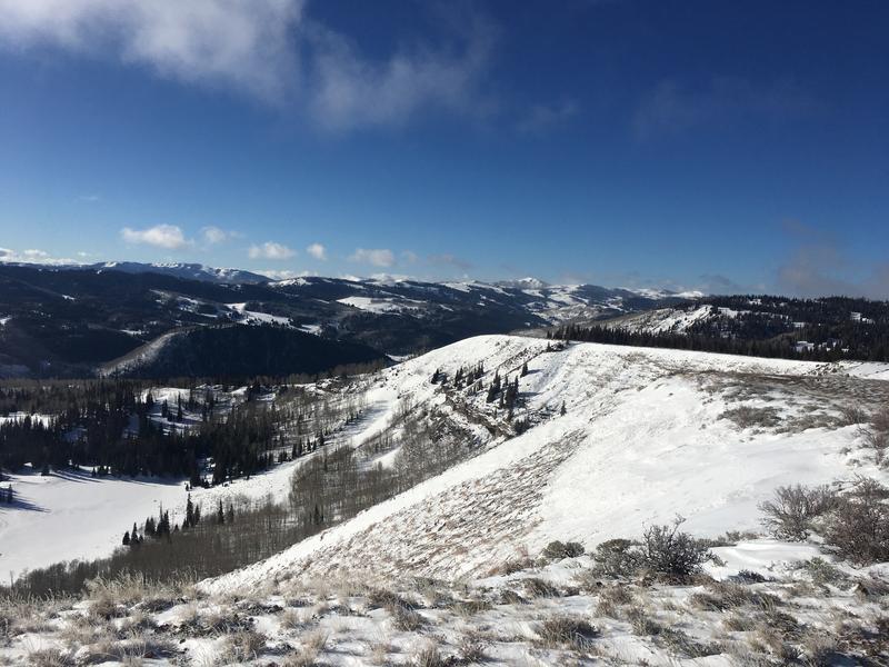
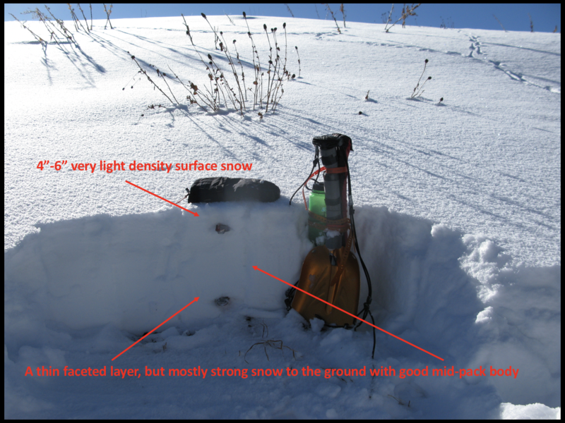
Mark was near Wolf creek yesterday and found a snowpack that is thin and travel limited to grassy slopes and road rides. Mark's observation is found here
Looking for real-time temps, snow, or wind?
Click here and then on the "western Uinta" tab for western Uinta specific, weather station network.
Recent Avalanches
No new avalanche activity to report.
To view trip reports and recent avalanche activity, simply click here.
Ad
Avalanche Problem #1
Normal Caution
Type
Location
Likelihood
Size
Description
Snowpack structure from Wolf Creek Pass in the image above suggests a relatively homogenous pack... and that's good news considering the overall shallow nature of current snow depths through the range.
While the avalanche hazard is generally LOW, there's enough light density snow to blow around and there may be a shallow, fresh wind drift that reacts to our additional weight. Sure... you'd really have to go out of your way to find an avalanche today, but if you do trigger a slide the danger of slamming into a season ending obstacle is very real. So... look for and avoid any fat, rounded piece of snow, tone it down, take it slow and remember- it's a long season and you definitely don't want to instantly end it before things get going.
Additional Information
We are in the process of establishing a snow study site near Camp Steiner. The automated weather station delivers real-time snow fall, total snow depth, and current temperatures. This data fills in a big black hole of snow information near Mirror Lake. Last week, we visited the site to establish comms with Lofty Lake Peak and all is go to start hauling the gear into place this week. I'd like to give a big shout out to Sean and Jesse from the NWS along with Ted Scroggin, our main man in the Uinta's... the entire crew is pictured above.
I'll update this forecast by 7:00 AM tomorrow, Thursday December 3rd.
Your observations are import, so please let me know what you're seeing... click HERE and contribute to this amazing community based program
Information on outdoor recreation - The State of Utah created this webpage with information about recreating on both state and federal public lands during the current health crisis.

Skiing and riding at closed ski resorts - Some resorts allow access now, and some do not. Please check HERE for the latest info on ski area access.

New to the backcountry (including riding at closed resorts) - Watch the award-winning, 15 minute Know Before You Go video, or take the 5-part, free online-learning series.
General Announcements
If you see or trigger an avalanche or just wanna let me know what you're seeing you can reach me directly at 801-231-2170 or [email protected]
The information in this forecast is from the US Forest Service which is solely responsible for its content.