Join us at our 2nd Annual Blizzard Ball

Forecast for the Salt Lake Area Mountains

Trent Meisenheimer
Issued by Trent Meisenheimer on
Wednesday morning, November 18, 2020
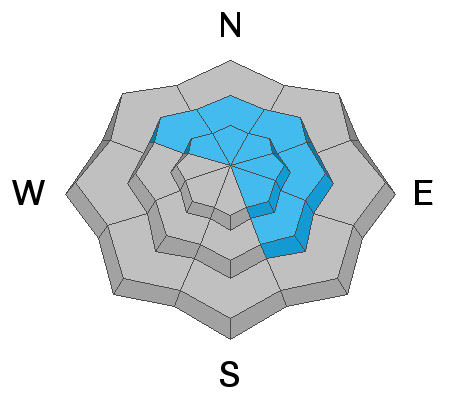
The avalanche danger is MODERATE today on slopes loaded by the wind, where it is possible to trigger a small wind drifted snow avalanche that could be hard or soft. The avalanche danger is LOW on slopes that aren't being loaded or affected by the wind.
Low
Moderate
Considerable
High
Extreme
Learn how to read the forecast here
Special Announcements
Please do everything possible to avoid getting hurt for yourself and the greater good. As you decide where and how to travel in the backcountry, consider adding just a little extra margin of safety.
Announcement: Please visit this website with information about Responsible Winter Recreation by the Utah Office of Outdoor Recreation.
Weather and Snow
The trough over the Pacific Northwest will swing a cold front into Utah later this afternoon. Ahead of this trough, we will continue with strong winds from the southwest into the afternoon before the winds veer to the west and decrease in speed. We can expect the temperatures to drop and some scattered snow showers to develop by early evening, continuing into the overnight hours. This storm will likely drop a trace to 3" of new snow and return the mountain temperatures to normal.
The south & west winds currently spin the mid and upper elevation anemometers at speeds of 35-40 mph, gusting into the 50's & 60's. Mountain temperatures continue to be warm, with all stations staying above freezing overnight. Mountain temperatures will climb into the mid 40's °F at 9,000' before cooling off later in the afternoon.
It's getting harder and harder to find soft settled powder; however, it does exist in mid and upper elevation wind and sun-protected terrain. Other aspects are a mixed bag of sun and wind crusts.
Recent Avalanches
No new avalanches were reported from the backcountry yesterday. All backcountry observations can be found HERE.
Ad
Avalanche Problem #1
Wind Drifted Snow
Type
Location
Likelihood
Size
Description
Yesterday morning the southerly winds picked up and continue to blow across the mid and upper elevation terrain at speeds of 30-40 mph. Even mid-elevation stations like Reynold Peak in Big Cottonwood are reading speeds of 35-40 mph, gusting to 56. With such strong winds, the drifted snow will likely be scattered throughout the range, and drifts might be found in unusual locations, like mid-slope break-overs.
These new drifts of windblown snow will be shallow and could be hard or soft. These drifts will not be much of a problem unless you find yourself in very exposed terrain where even a small avalanche can knock you off your feet. The consequences of avalanches drastically change, depending on the terrain you are in.
General Announcements
This information does not apply to developed ski areas or highways where avalanche control is normally done. This forecast is from the U.S.D.A. Forest Service, which is solely responsible for its content. This forecast describes general avalanche conditions and local variations always occur.