Join us at our 2nd Annual Blizzard Ball

Forecast for the Salt Lake Area Mountains

Nikki Champion
Issued by Nikki Champion on
Thursday morning, April 9, 2020
The avalanche danger is LOW and normal caution is advised. The three things to watch for today are (1) wet avalanches on all aspects as the snow surface warms throughout the day (2) unpredictable large glide avalanches in very specific places and (3) large cornices breaking back farther than expected along the ridgelines.
Pay attention to changing springtime conditions, if the skies clear and the snow surface becomes rapidly damp the avalanche danger could increase to MODERATE on steep solar slopes.
Low
Moderate
Considerable
High
Extreme
Learn how to read the forecast here
Special Announcements
The Avalanche Research Program at Simon Fraser University is conducting an online survey to examine how people use avalanche safety information. They want to hear from all backcountry users to understand how they process information provided in public avalanche forecasts. Anyone who completes the survey before May 15th will be entered to win cash prizes.
Uncertainty, Risk, & Decision Making: before, during, and after COVID-19 - Read this thought-provoking blog post about how we take risks by guest author Tom Diegel.
Weather and Snow
This morning under mostly clear skies the mountain temperatures range from the low to upper 30s F. Winds are south-easterly and lightly blowing 5-15 mph with gusts up to 20 mph.
Today will bring increased cloud cover and eventually scattered showers this afternoon. Temperatures should climb into the 40s and low 50s F. Winds will become easterly and continue to be light, gusting up to 30 mph at the highest elevations. This increased moisture could bring 1-3 inches of snow to the Central Wasatch before more dry weather tomorrow.
Another night of clear skies, near-freezing temperatures, and low relative humidity will have allowed for a generally good overnight refreeze at mid and upper elevations, leaving a firm supportable riding surface at these elevations this morning.
Recent Avalanches
Wet snow - Multiple signs of wet snow reported in the backcountry, including roller balls, pinwheels and easily triggered small wet-loose avalanches.
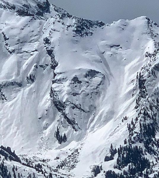
Glide Avalanches - Yesterday evidence of multiple Glide Avalanches were reported in the backcountry. One of these glide avalanches was reported in Stairs Gulch. The other two glide avalanches were reported in Broads Fork on Bonkers and Blue Ice.
Photo of glide avalanche release on Bonkers (M. White)
This occurs when a previously open glide crack releases and the entire snowpack slides as a unit to the ground. While these tend to be unpredictable, multiple occurring within a small time frame indicates conditions are currently suitable for these to release.
Find the full observation page HERE.
Ad
Avalanche Problem #1
Normal Caution
Type
Location
Likelihood
Size
Description
Today, the overall avalanche danger is LOW. This means that human-triggered avalanches are unlikely, but small avalanches in isolated areas are possible.
Today I would watch for:
1. Wet snow - Last night's overnight refreeze and today's increasing cloud cover should keep the snow surface cooler but as the day heats up and the snow gets wet, you should be able to trigger small loose wet avalanches. These usually start at your feet and fan out below you. However, watch out for these slides happening naturally especially if you are in a gully or any confined terrain where a small one could pile up deeply. Look for signs of wet snow like rollerballs.
Continue to maintain safe travel habits; this means exposing one person at a time to avalanche terrain and having someone watch them from a safe location.
2. Glide Avalanches - A separate but related avalanche problem, is glide avalanches. When they happen is mostly unpredictable. Several occurred within the last few days during the warm temperatures. Where they happen is generally predictable because there is often a huge crack in the snowpack. Common places to find glide avalanches are places with rock slabs or a smooth ground surface like Broads Fork, Stairs Gulch, and Mill B South, and upper Raymond Slabs in upper Porter Fork. Simply avoid being under these places or any slope with a visible glide crack.
3. Cornices - Cornices in some places are massive. These monsters are unpredictable especially during warm weather when they start bending downhill. Simply avoid being under or near the tops of large cornices as they break farther back than expected.
Additional Information
Information on outdoor recreation - The State of Utah created this webpage with information about recreating on both state and federal public lands during the current health crisis.

Skiing and riding at closed ski resorts - Some resorts allow access now, and some do not. Please check HERE for the latest info on ski area access.

New to the backcountry (including riding at closed resorts) - Watch the award-winning, 15 minute Know Before You Go video, or take the 5-part, free online-learning series.
General Announcements
This information does not apply to developed ski areas or highways where avalanche control is normally done. This forecast is from the U.S.D.A. Forest Service, which is solely responsible for its content. This forecast describes general avalanche conditions and local variations always occur.