March Kicks Off Our Spring Campaign- Donate Now to Support Forecasting

Forecast for the Uintas Area Mountains

Craig Gordon
Issued by Craig Gordon on
Wednesday morning, March 18, 2020
The avalanche danger changed overnight-
In the wind zone, at and above treeline, a MODERATE avalanche danger exists on steep, wind drifted slopes, especially those facing the north half of the compass. Human triggered slides are POSSIBLE on the leeward side of upper elevation ridges and around terrain features like chutes and gullies.
This is an easy avalanche problem to avoid... simply lose some elevation, lose the wind, and steer towards wind sheltered, mid and lower elevation slopes where you encounter LOW avalanche danger..
Low
Moderate
Considerable
High
Extreme
Learn how to read the forecast here
Special Announcements
We know there is a lot of uncertainty regarding the Coronavirus, but the Utah Avalanche Center is planning to continue issuing regular avalanche forecasts into April.
Uphill Travel at Ski Areas -
Some resorts will be offering limited uphill access but not all do. Up to date info about uphill access from Ski Utah is posted HERE.
Weather and Snow
Currently-
Snow developed over the region a few hours ago and a nice little storm is starting to take shape. With just an inch or two so far, nothing to get too excited about just yet, but a reset is on the way. Currently, skies are cloudy, light snow falls, and temperatures are in the mid 20's. Southerly winds are busy at work, blowing 30-50 mph along the ridges. Riding and turning conditions are gonna be hit or miss for a minute or two, so strategy and timing are key. Get some morning chores done around the house and not only are you rewarded as a garage organizing hero... you'll get the green light to get out and score some soft snow late in the day. Done and done :)
Uinta weather network info is found here. Simply click on the Western Uinta tab.
For today-
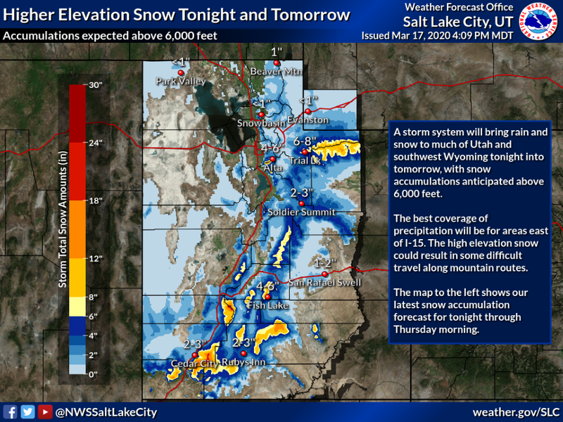
The image above says it all. Look for snow throughout the day with 6"-8" stacking up by about dinnertime. Temperatures climb into the 30's. Southerly winds continue blowing in the mid to upper 30's, with a few gusts nearing 50 mph along the high ridges.
Futurecast-
Cool and unsettled with occasional snow showers through late Thursday.
Recent Avalanches
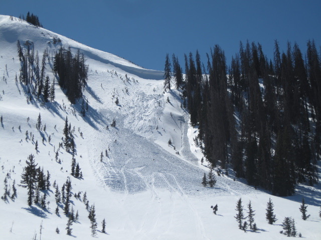
Ted stomped around Moffit Basin yesterday and found a few older wind slabs triggered over the weekend. Isolated to steep, leeward slopes, this is the type of terrain and the kind of avalanche problem you're most likely to encounter today. More on Ted's travels found here.
To view additional trip reports and recent avalanche activity, simply click here.
Ad
Avalanche Problem #1
Wind Drifted Snow
Type
Location
Likelihood
Size
Description
A couple inches of snow, coupled with strong wind, whips up shallow, yet predictably sensitive drifts that'll react to our additional weight. While isolated to steep, leeward terrain in the wind zone, this straight-forward avalanche problem is easy to detect and easy to avoid. Simple look for and avoid fat, rounded pieces of snow, especially if they feel or sound hollow like a drum. As snow stacks up and winds continue blowing, wind drifts become more connected and may break deeper and wider than might expect. By days end, fresh drifts may be large enough to knock you off your ride and let you know who's boss.
General Announcements
The information in this forecast expires in 24 hours, but will be updated by 7:00 AM Thursday Mar. 19th.
This forecast is updated daily by 7:00 AM.
In the mean-time, if you see or trigger an avalanche or just wanna let me know what you're seeing you can reach me directly at 801-231-2170
The information in this forecast is from the US Forest Service which is solely responsible for its content.