

Observation Date
2/15/2020
Observer Name
Greg Gagne
Region
Salt Lake » Big Cottonwood Canyon » Silver/Days
Location Name or Route
Days/Silver Forks
Comments
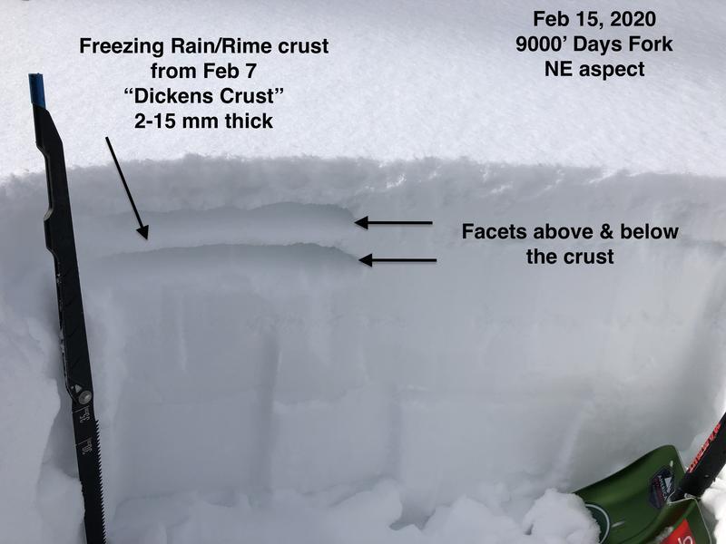
Went out today to look at the top 15-30 cms of the snowpack ahead of hopefully a good refresher beginning on Sunday. Key points:
- A freezing rain/rime crust that formed on Feb 7 is buried underneath 5-15 cms of snow. This crust varies in thickness from one drainage to the next, with the strongest crust I have seen in Millcreek and Little Cottonwood. I'm seeing the most variability in Big Cottonwood Canyon. There is faceted snow above and below the crust.
- Snow surface looked quite weak on Thursday, but recent warmth & cloud cover have helped heal weaknesses and overall the snow at the surface does not look especially weak. Ski cuts on very steep northerly aspects at 10,000' could only produce minor sluffing at best.
- Below about 8500' on all aspects warmth has really helped heal snow surface, and with the onset of the storm being warm, I would expect the new snow to bond well to the existing snow surface.
- Above 9,000' you can begin to find weaker snow on northerly aspects (in particular, NW thru NE), but overall it is no longer as weak as it looked on Thursday. I only got as high as 10,200' and there may be weaker snow at higher elevations.
-Most slopes facing west through south and east have a sun and temperature crust and the new snow should bond well to this surface.
- Strong winds and heavy dense snow may quickly overload some slopes, and the Feb 7 crust may act as an excellent bed surface for avalanches to run fast and far.
- The weakest snow I am finding is faceted snow underneath the Feb 7 crust.
Overall I am feeling much better about conditions now than I did on Thursday as the weak snow at the surface has seemed to gain strength due to recent warm temperatures.
Today's Observed Danger Rating
Low
Tomorrows Estimated Danger Rating
Moderate