Forecast for the Moab Area Mountains

Eric Trenbeath
Issued by Eric Trenbeath on
Friday morning, January 17, 2020
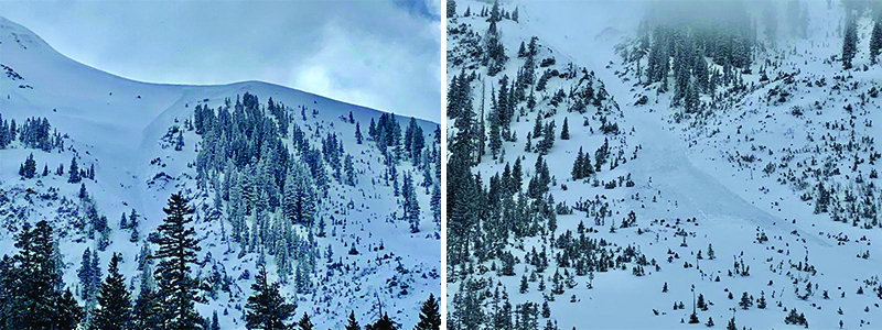
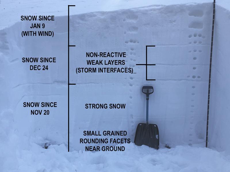
Strong southerly winds over the past several days have continued to blow and drift snow and the avalanche danger remains MODERATE at mid and upper elevations. Look for fresh drifts to form today on slopes facing NW-N-SE. Recent wind drifts will be recognizable by their smooth rounded appearance, and cracking is a sign of instability.
Low
Moderate
Considerable
High
Extreme
Learn how to read the forecast here
Special Announcements
You can listen to my radio interview with Lisa Hathaway on KZMU by clicking here then selecting Mon, Jan 13, then scroll down and play "Thought for Food/Public Affairs."
Our Backcountry 101 avalanche course has been scheduled for February 15, 16. The cost is $150. The course starts with a 4-hour classroom session the night of the 15th followed by a day in the field. It's a great way to increase your avalanche awareness and backcountry travel skills. Click here to register. A huge thanks to Moab Gear Trader for sponsoring this course. Please visit them for all your winter backcountry needs
Road Conditions: The road is plowed but snowpacked. Be aware of blown and drifted snow.
Grooming update: Matt groomed all the trails on Wednesday.
Weather and Snow
24 Hour Snow T" Weekly Snow 3" Base Depth in Gold Basin 40" Wind S 33 G49 Temp 21F
Stop me if you've heard this before - strong southerly winds have been cranking for the last 24 hours and continue to do so. Trace amounts of snow have fallen as of 7:00 a.m. A fast-moving storm system is blasting through the area this morning bringing with it a chance for a few inches of snow before it exits the area this afternoon. SW winds will blow in the 20-30 mph range with gusts in the 40's before swinging around to the NW as the storm exits the region. High-pressure will build through the weekend with dry conditions remaining into mid-week. A return to a more active pattern is being advertised for later next week.
Wind, temperature, humidity on Pre Laurel Peak (11,700')
Storm totals at Gold Basin Study Plot (10,000').
Snotel site near Geyser Pass Trailhead (9600').
NWS weather forecast
Recent Avalanches
Dave Garcia observed this avalanche on Monday off the shoulder of the NE face of Tukno. If you read that day's forecast, I noted the potential for this particular path, a classic runner with only a few inches of snow and strong SW winds. Though not a large avalanche, it's remarkable how much snow was entrained, and how far it ran.
Ad
Avalanche Problem #1
Wind Drifted Snow
Type
Location
Likelihood
Size
Description
Strong southerly winds continue to keep the threat of wind slabs alive. Drifts formed earlier in the week have grown stubborn and more difficult to trigger, but fresh wind slabs continue to form. Today's fresh drifts should be quite shallow but triggered avalanches ranging from a few inches up to 18" deep are possible. Be very suspicious of smooth, rounded pillows, and harder surfaces that feel and sound hollow like a drum. The slabby conditions are difficult to ski, and their stubborn nature may lure you further on to them before they release. For safety and snow quality, stick to sheltered, non-wind loaded terrain.
Additional Information
Wind slab danger notwithstanding, the state of our overall snowpack is looking good. On Tuesday, pro observers Dave Garcia, Nate Ament and I dug a full depth pit on a north aspect at around 10,800'. The season snowfall history can be clearly detailed. The only weak layers we observed are at storm interfaces that have occurred since Christmas Eve. These have been non-reactive for some time and are showing a general trend towards strengthening. Since we didn't get early season snow, we are blessed to not have a layer of weak, sugary facets, or depth hoar at the base of the snowpack. The facets that do exist at the base of the pack are small-grained and are rounding which signals a trend toward strengthening.
I've included both a Photoshop profile and Dave Garcia's Snowpilot profile so you can compare the two and see how they correlate. The hand hardness tests you see in the photo are noted along the bottom of the Snowpilot profile as fist (F), four finger (4F), one finger (1F), pencil (P), and knife (K). In this way you can see how the snowpack generally gains strength as it goes down. Also note the weak interfaces at 67, 80, and 102 cms.
General Announcements
Check out the avalanche beacon training park at the Geyser Pass Trailhead and practice your rescue skills!
This forecast is from the U.S. Forest Service, which is solely responsible for its content. This forecast describes general avalanche conditions and local variations always occur.