Observation: Uintas

Observation Date
1/10/2020
Observer Name
jg
Region
Uintas
Location Name or Route
Smith and Morehouse Environs
Weather
Sky
Few
Wind Direction
Northwest
Wind Speed
Calm
Weather Comments
Beautiful day weather-wise. Pleasant at the trailhead and temps in the single digits at 10K. Hardly a breath of wind. Mostly clear skies until later in the day when clouds started filtering in from the SW.
Snow Characteristics
New Snow Depth
12"
New Snow Density
Low
Snow Surface Conditions
Powder
Snow Characteristics Comments
Beautiful, cold, right side up powder.
Red Flags
Red Flags
Poor Snowpack Structure
Avalanche Problem #1
Problem
Persistent Weak Layer
Trend
Increasing Danger
Problem #1 Comments
Multiple persistent weak layers in the area we traveled. A layer 45 cms down (18") produced Q1 shears on CT's but didn't propagate across the extended column in ECT's. Another layer 79 cms down (31") produced clean shears in CTs but didn't propagate across the extended column in ECT's. Basal facets were rounding and I could not get any failure on this layer. Increasing danger with more new snow forecasted.
Avalanche Problem #2
Problem
New Snow
Trend
Decreasing Danger
Snow Profile
Aspect
Northwest
Elevation
10,300'
Slope Angle
30°
Comments
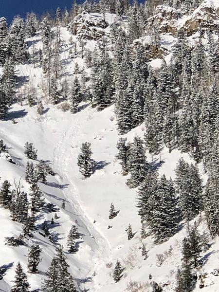
Snow pit tests didn't produce alarming results but it did identify multiple persistent weaknesses in the snowpack in the area I traveled.
We'll have to see what this storm brings snow and water-wise but its forecasted to bring us a foot plus of snow in the next couple of days, will it be enough to overburden the persistent weak layers? No question, increasing danger over the next couple of days, so it's heads up traveling in the backcountry if you're going to get out this weekend. Considerable danger tomorrow if forecast verifies.
Storm snow avalanche on a steep SE facing slope.
Today's Observed Danger Rating
Moderate
Tomorrows Estimated Danger Rating
Considerable