As Craig stated in his forecast this morning it is a tale of 2 different snowpacks, both equally as dangerous but one of them is unfamiliar and not something we deal with a lot.
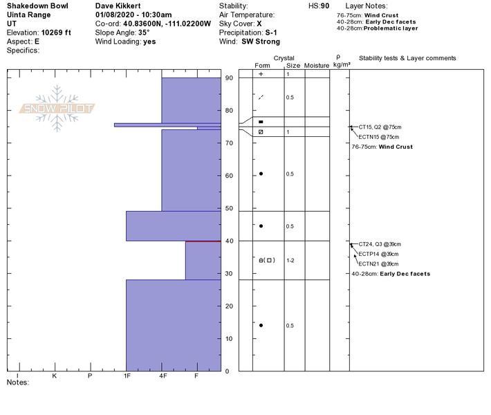
1.) The persistent weak layer issue involving old faceted snow near the ground is still present and showing signs of strengthening but it is not there yet. My snowpit on an east facing slope at 10,200 ft showed a height of snow of 90 cm's with the weakest snow down at 40 cm. I was able to get full propagation on this layer with an ECTP 24. I did another and it yielded ECTN 15 on the same layer. The poor structure is evident (strong over weak) and that's all I need to know. My take is that this layer has adjusted to the slab on top for now, but with more wind and water (snow) this layer has the potential to come back to life producing large connected avalanches. We have multiple waves of moisture forecasted over the next week, and little by little this layer will get stressed. There is much uncertainty about how much it will take to make this layer reactive again.
2.) WE NOW HAVE A PERSISTENT WEAK LAYER ON SOUTH ASPECTS!!! This is a very unusual set up for us and has already caught many off guard with folks taking rides but luckily everyone walking away to ride another day. DON'T LET THIS BE YOU!!! Here is my take on how this setup happened. Beautiful low-density snow over Christmas was kissed gently by the sun on the day of the 26th. That created a thin temperature crust on our solar aspects including the west. Remember weak snow forms above and below crusts... It remained cold the following two days and the snow underneath the crust began to get weak and faceted. Our New Years' storm now sits on top of this crust preserving the weak snow. This layer has adjusted to the new snow on top but it is VERY SUSPECT with any new snow and wind on top which is forecasted to happen over the next week. From my little experience in this wild field of snow and avalanches, anytime you have a facet crust combo with a slab on top these avalanches can break much further than you might expect. Today it felt like the beginning of a rubber band that will slowly start to get stretched. Little shots of snow here and there may not be enough to make these avalanches fail naturally. If we do get the wind and water over the next week these avalanches will be very reactive to the weight of a skier, rider, or snowmobile. Heads up. Beginning now it is best to avoid all steep slopes at the mid and upper elevations. Have patience and let this beautiful winter unfold and blanket our mountains with more snow. The good news is there is plenty of good riding on low angle protected slopes.
Explosive work produced a 20-30 ft wide D1 avalanche on facets below the crust on a Southwest facing slope at 10,500 ft. This avalanche picked up some steam moving down the slope and put a nice debris pile in the gully below.