Observation Date
12/18/2019
Observer Name
Zimmerman-Wall/Bremer/Latosuo AIARE PRO 1
Region
Salt Lake » Little Cottonwood Canyon » Snowbird periphery » Mary Ellen
Location Name or Route
Mary Ellen Gulch/Mineral Basin
Red Flags
Red Flags
Poor Snowpack Structure
Avalanche Problem #1
Problem
Persistent Weak Layer
Trend
Same
Problem #1 Comments
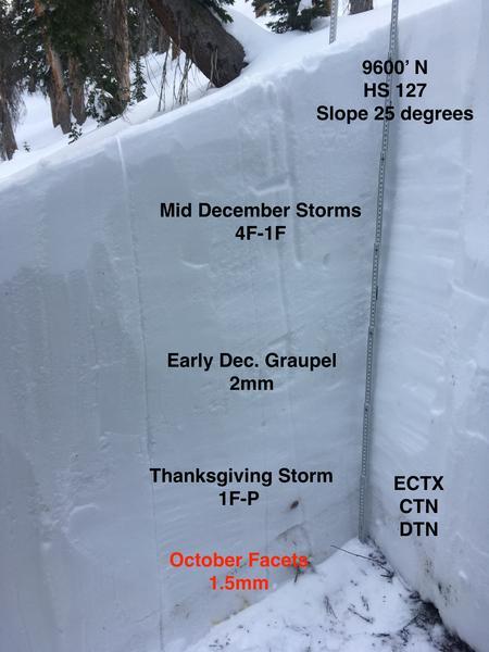
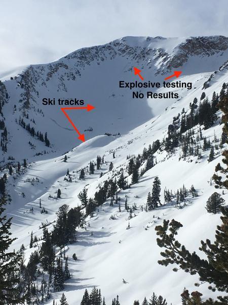
Still there. The October basal facets, while dry, have a tendency to stick together well when squeezed and they don't come pouring out of the pit wall. They are 1.5mm in size and 4F in hardness. Test results in the forested mid-elevation terrain visited did not produce consistent sudden fractures nor did they show a propensity to propagate in our large column tests. Evidence from previous days explosives testing in high elevation Northerly facing terrain also did not yield any avalanches. This somewhat surprising, but not out of the ordinary with a persistent weak layer such as this. As one colleague pointed out, it may take another significant widespread loading event such as a 2-3" H2O storm to really test this layer across the range. In the core of the Cottonwoods and upper most AF canyon where the snowpack is deeper, we may be turning the corner towards increasing strength and improved stability, but the periphery is still suspect. Unsupported slopes and terrain features with underlying rocky convexities also have a high index of suspicion.
Avalanche Problem #2
Problem
Wind Drifted Snow
Trend
Increasing Danger
Problem #2 Comments
Noted winds at the highest ridge line (Timp, Silver Creek, Hidden Peak) were enough to transport snow. The variety of wind directions over the last 24 hours from N to S lead us to be considerate of the upper elevation starting zones and to be aware of the effects of terrain influence on loading patterns.
Comments
The weather trended from sunny to overcast, winds steadily increased into the moderate category, and the temps began falling around 2pm. The next weather event doesn't look to do much to the overall hazard and may only deteriorate riding conditions in all but sheltered northerly terrain. Expect the melt freeze crusts on steeper southerlies to be stout by tomorrow. Settled powder in the mid elevation band seems like the ticket for now.
Today's Observed Danger Rating
Considerable
Tomorrows Estimated Danger Rating
Moderate
Coordinates


